Snodland to Sole Street Walk
The North Downs, hilly with views after lunch, and tranquil Luddesdown for tea.

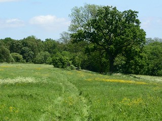
walk_17_pc_Oxe eye_daisies_in_late_May
May-05 • Peter Conway on Flickr
swcwalks book2 walk17 37325098105


walk_17_pc_Pushing_up_the_daisies_in_Luddesdown_churchyard
May-05 • Peter Conway on Flickr
swcwalks book2 walk17 36487218184

The North Downs & Kent's Weald Way
| Length |
13.1km (8.1 miles), 4 hours. For the whole outing, including trains, sights and meals, allow at least 7 hours |
|---|---|
| Maps |
OS LandRanger Map No. 178 OS Explorer Map No. 148. Snodland, map reference TQ 706618 is in Kent, 7.5km north west of Maidstone. |
| Toughness |
5 out of 10 |
| Features |
Don't be put off by the rather industrial nature of the train ride to the start of this walk. As soon as you leave Snodland it becomes rural and peaceful with good views and a surprisingly away-from-it-all feel. The majority of the walk is over the North Downs, mostly through wooded areas and across open fields and is hilly at times. Some paths may be overgrown with nettles in summer, so shorts aren't recommended. Soon after lunch at Harvel, the views open out before you descend into tranquil Luddesdown, with its historic church and what may be the oldest continually inhabited house in the country. In summer, you're likely to encounter Kent's favourite sport - cricket - both on the green behind the lunchtime pub stop - which comes half-way round the walk - and in Luddesdown behind the Victorian school. Real-ale lovers will enjoy the tea stop - the Cock Inn at Luddesdown. |
| Walk Options |
At the lunch stop, you could ring for a taxi to Meopham Station (about five miles away). Sole Street Circular Walk: 13.5 km (8.4 miles). The route starts from Sole Street, which has a direct train service from London Victoria. It heads east to Lower Luddesdown before continuing south to pick up the Weald Way to then link up with the Snodland to Sole Street walk directions 1km from Harvel. This option is now included in the 2011 edition. An alternative start to this walk from Cuxton and an afternoon extension is available in the pdf for the Cuxton to Sole Street walk (SWC walk 35) on this website. The alternative start takes you along a wooded ridge, with fine bluebells in late April and early May, and one good wood anemone wood in late March and early April, to the lunchtime pub for this walk in Harvel. This makes a morning of 10.3km (6.4 miles) or 8km (4.9 miles) depending on which route you take from Cuxton. This makes a total walk of 16.6km (10.3 miles) or 14.3km (8.9 miles). The extension takes you in a loop from the Cock Inn in Henley Street up to Cobham, adding 5.6km (3.5 miles) to the walk, thus making a total walk from Snodland of 18.7km (11.6 miles). |
| History |
Snodland was the largest village in England until it took on town status in 1988.Until the 19th century, the town - the name probably derives from a person 'Snod', one of the Saxons buried on the Hill - was a small agricultural village, the population in 1801 just 312. But paper and cement manufacture changed all that and the current population is around 9,000. The town's most famous landmark is the Snodland Clock Tower, built in 1877 by the Hook sisters in memory of their brother Charles. The Hook family were the owners of the Townsend Hook Papermill that borders the Medway. The 15th-century Hall House, opposite the Red Lion pub, once a smallholding growing hops for beer. The village of Harvel actually means Hart land - open land frequented by harts and stags - recorded as Hertfelde in the late 13th century and amended by local dialect. Luddesdown is a remote, peaceful village surrounded by organic farmland, nestling in a picturesque valley. How different things would have been if the Ministry of Defence had got its way in 1983 and been allowed to take over 500 acres of prime farmland for year-round training for Army minelaying and tactical exercises. A tank was brought into the valley to demonstrate its low noise levels but this - literally - backfired and, after fierce opposition from local people, the plan was scrapped in 1984. Luddesdown Court (not open to the public), beside St Peter and Paul church with its Norman tower, dates from 1100 and has features from Saxon, Norman, Tudor and Jacobean times. It [is considered to] may be England's oldest continually occupied house. |
| Saturday Walkers Club |
Take the train nearest to 9.30am (before or after) from Charing Cross Station to Snodland. You will have to change at Strood (on the Gillingham line). Journey time: 1 hour 11 minutes. Trains back from Sole Street to Victoria run twice an hour. Journey time 57 minutes. Buy a day return to Snodland. (Note. Snodland and Sole Street are on different lines. Generally ticket inspectors are pretty reasonable about accepting a return ticket from another line if you explain that you have been walking. However you can play safe by purchasing a travelcard for zones 1- 6 and then just buy a return from zone 6 to Snodland. Then if your return ticket is not accepted, at least you will only have to pay for a single to the zone 6 boundary: St. Mary Cray, 5 stops up the line) |
| By car |
It is recommended that you leave your car at Strood station and catch the train to Snodland. For the return train from Sole Street to Strood change at Rochester. |
| Lunch |
Picnic Virtually anywhere along the route would be a good picnic spot. |
| Tea |
The suggested tea place is the Cock Inn (tel 01474 814208) in Henley Street. Known for its real ales and featured in the Good Beer Guide, it also serves tea and coffee and has a seafood bar at weekends, serving until 8pm. (Please note: allow 15 minutes to walk to Sole Street station from the pub.) The Railway Inn, beside Sole Street Station, is open for lunch and then from 6.30pm when it also serves food. Sole Street Post Office, which is 50 metres from the Railway Inn and sells drinks and snacks, is open until 6.30pm Monday to Friday, 7.30pm on Saturday and 1pm on Sunday. |
| Current Issues |
The Amazon and Tiger is closed. Licensee retired 2021. A local group the Harvel Collective, are attempting to save the pub. They can be reached via email. Past times. |
| Book |
This walk was originally published in Time Out Country Walks near London volume 2. We now recommend using this online version as the book is dated. |
|---|---|
| Profile | |
| Help Us! |
After the walk, please leave a comment, it really helps. Thanks! You can also upload photos to the SWC Group on Flickr (upload your photos) and videos to Youtube. This walk's tags are: |
| By Train |
Out (not a train station) Back (not a train station) |
| By Car |
Start Map Directions Return to the start: Finish Map Directions Travel to the start: |
| Amazon | |
| Help |
National Rail: 03457 48 49 50 • Traveline (bus times): 0871 200 22 33 (12p/min) • TFL (London) : 0343 222 1234 |
| Version |
Feb-17 DAC |
| Copyright | © Saturday Walkers Club. All Rights Reserved. No commercial use. No copying. No derivatives. Free with attribution for one time non-commercial use only. www.walkingclub.org.uk/site/license.shtml |


Walk Directions
Full directions for this walk are in a PDF file (link above) which you can print, or download on to a Kindle, tablet, or smartphone.
This is just the introduction. This walk's detailed directions are in a PDF available from wwww.walkingclub.org.uk