Hassocks to Upper Beeding walk
3 steep hills with fine views before lunch at Devil's Dyke. A gentle ridge walk in the afternoon to Upper Beeding (short bus ride to Shoreham station)
Start of the Valley Ending
Hassocks to Upper Beeding walk
Aug-16 • Saturdaywalker on Flickr
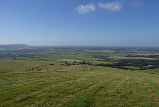
swcwalks book2 walk23 walkicon banner 28522191563

Downs view towards the end
Hassocks to Upper Beeding walk
Aug-16 • Saturdaywalker on Flickr
swcwalks book2 walk23 walkicon 28522191863
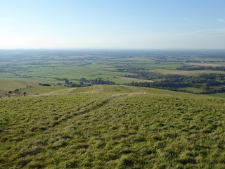
Valley Ending view
Hassocks to Upper Beeding walk
Sep-18 • Saturdaywalker on Flickr
swcwalks book2 walk23 walkicon 44549127884


walk 23 Truleigh Hill from Wolstonbury Hill
Jun-05 • Peter Conway on Flickr
swcwalks book2 walk23 37151997052

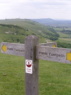
Devil's Dyke and the South Downs escarpment
| Length | Main walk: 16.3 km (10.1 miles) Via Valley Ending: 18.7km (11.6 miles) Ending in Shoreham: 21km (13 miles) |
|---|---|
| Maps | OS Landranger Map No 198. OS Explorer Map OL11 (formerly 122) |
| Toughness | 7 out of 10 |
| Features | It is a matter of opinion which is the finest view in South East England, but the amazing panorama from Devil's Dyke on the South Downs escarpment must surely be a strong contender. Such beauty comes at a price, however, and the area immediately around the viewpoint can be exceedingly busy on a fine weekend. However, the South Downs also afford numerous other less frequented viewpoints, and this walk introduces you to several of them, including tranquil Wolstonbury Hill and Edburton Hill. The morning in particular is a delightful series of climbs and descents on slopes covered by rare chalk grassland. In the afternoon - which is somewhat easier on the leg muscles, though still with a couple of short uphill sections - you follow the South Downs Way for a while across Fulking Escarpment, before descending into the riverside village of Upper Beeding for tea. |
| Walk Options | The valley ending - a slightly longer ending to the walk (an additional 2.4km/1.5 miles, making a total walk of 18.7km/11.6 miles) - avoids civilisation all the way into Upper Beeding. It takes you on a dramatic route down the front of the Downs, with magnificent views, and then across tranquil water meadows and pasture to Upper Beeding. Note, however, that this way can be waterlogged in winter and so is not recommended from October to March. There are two possible routes for ending in Shoreham. The recommended route, for which detailed walk directions are provided, takes a high route along a quiet road, with fine views of the Adur valley, and then detours via a farm and the Mill Hill Nature Reserve (a great place to see Adonis Blue butterflies in May, late August and early September, and also Wall butterflies in May and late July or early August), to join the Adur river path near to Shoreham. This version is 21km (13 miles). An alternative is to follow the South Downs Way down into the valley, and then turn left onto the path along the River Adur all the way into Shoreham: but on this route, which is 21.5km (13.3 miles), you are near a main road for much of the walk along the Adur. A GPX file is provided for this route, and very brief walk directions. There is also a GPX-only ending at Fishersgate railway station. This crosses the heart of the downs on an attractive path, but its last mile passes through a rather industrial part of the Brighton conurbation and has no tea options at its finish. On Saturdays, Sundays and public holidays (daily in July and August) you can do either the morning or afternoon of the walk as a separate outing using bus no.77 from Brighton. The morning of the walk is 8.9km (5.5 miles) and the afternoon 7.4km (4.6 miles) via the main walk route or 9.7km (6 miles) using the valley ending. |
| Transport | Two Thameslink trains an hour go from St Pancras, Blackfriars and London Bridge to Hassocks daily (journey time 57 minutes from London Bridge) and there are also two hourly trains from Victoria on weekdays and one an hour at weekends, taking 54 minutes. Take the train nearest to 9.20am from Victoria or London Bridge to get to lunch in time. The best ticket depends on which bus you take to return from Upper Beeding: see below. To return from Upper Beeding, there are two options: - On Mondays to Saturdays only you can get bus number 100 from Upper Beeding to Burgess Hill station, which is one stop up the line (London-bound) from Hassocks. This goes hourly at 18 minutes past the hour until 5.18pm and then 6.22pm and takes 40 minutes. There is no Sunday service. The fare for this was £5.90 in September 2018 and at one point you get a fine valley view of Wolstonbury Hill, which you walked over earlier in the day. If taking this option your train ticket only needs to be a day return to Hassocks. - At other times - until up to 11pm Mondays to Saturdays and until 6.40pm on Sundays - you can take bus number 2, which runs to Shoreham-by-Sea station hourly, taking about 15 minutes. To check times see www.buses.co.uk. From Shoreham there there are two direct trains an hour to London Victoria from Monday to Saturday and one an hour on Sunday (journey time 1 hour 15 minutes); change at East Croydon to get back to London Bridge. If doing this option your train ticket needs to be a day return to Shoreham-by-Sea (NOT Shoreham, Kent). |
| Lunch | Wildflour Cafe 7km (4.4 miles) into the walk, this farmyard refreshment kiosk with tables pleasantly arranged around a courtyard, serves cakes, cream teas and hot food such as dahls and chillis, all vegetarian or vegan. It is open 10am to 4pm (at least in summer) Tuesdays to Sunday. Near the entrance to the cafe is a drinking water tap, and it also has toilets.
Devil’s Dyke pub (01273 857256, www.vintageinn.co.uk/thedevilsdykebrighton). 8.9km (5.5 miles) into the walk on the lip of the South Downs escarpment, this large pub is always busy but very efficient. It serves food all afternoon daily, so on a fine summer weekend it can be a positive advantage to turn up after the lunchtime rush.. This walk also affords many excellent places for a picnic, including Wolstonbury Hill, the rim of the Devil's Dyke itself, the area in front of the Devil's Dyke pub, and Edburton Hill. |
| Tea | The Youth Hostel on Truleigh Hill has a serving hatch offering hot and alcoholic drinks, plus some cakes and snacks, to 9pm daily (at least in the summer months). It also has a drinking water tap just to the left of its main entrance. The Kings Head in Upper Beeding (01903 812196) is conveniently sited at the end of the walk, and has quite a large garden (though it is well hidden!). The Old Tollgate Restaurant & Hotel and the Castle Inn Hotel in Bramber are two possible other tea options: for details see the walk directions pdf. Shoreham has a range of cafes and pubs, the former particularly in its pedestrianised area near the church. |
| Swimming | Shoreham beach - a short detour off the Shoreham ending - is an excellent place for sea swimming, with gently shelving shingle, leading down to a flat sand/mud bottom at very low tide. To reach it, cross the footbridge across Shoreham harbour in the town centre and walk 300 metres down the road beyond. |
| History | Hard though it is to believe it now, in their natural state the South Downs would have been thickly forested like the rest of England. The first clearance was in the Neolithic period (the Stone Age), when the Downs were favoured by settlers for their easily cultivated soil and defensive advantage. Later the Downs were more used for animal pasture, creating unique chalk grasslands. Grazing kept the grass short, enabling a wide range of wild flowers to grow. During the Second World War and with the advent of modern farming, large areas of the Downs were ploughed up to grow cereals, The remaining pastures were often neglected, allowing the spread of bushes and reducing wild flower populations. Conservation efforts today tend to focus on reintroducing grazing to the remaining grasslands: the sheep or cows you see on this walk are thus very much workers in the environmental cause. The South Downs Way, created in 1972, was the Britain's first long distance bridleway. Many of the paths it uses, as well as the broad paths that climb slantways up the front of the Downs escarpment to join it, were originally drove roads for moving livestock herds. It used to be assumed that Wolstonbury Hill was an Iron Age (600-100 BC) fort, but recent research by the University of Bournemouth has cast doubt on that. The fact that its earth rampart is outside of the ditch not the other way round suggests that it may in fact have been a stock pen for keeping cattle or other livestock in. However, it the researchers also concluded it was probably a bit older than originally thought - late Bronze Age, perhaps Devil's Dyke is a steep sided valley, characteristic of the South Downs, and caused by water erosion. One legend has it that the valley was an attempt by the Devil to dig a channel to the sea in order to flood southern England and prevent the spread of Christianity. (If so, he was digging in the wrong direction). A local farm woman supposedly scared the Devil away by lighting a candle and setting her cockerels crowing. Bramber Castle (slightly off the route: see directions in the text) is a ruined Norman castle that once dominated a huge estate in the South of England and was originally on an inlet of the sea. Built shortly after the Norman Conquest in 1066, it was one of five key castles that guarded strategic valleys leading down to the south coast, and thus protecting William the Conqueror's supply lines to Normandy. Occupied by the de Braose family, it fell into disrepair after the family died out in 1394. It is now open to the public (free entry: no fixed hours). There is not a whole lot to see, but the surprisingly large site has a certain romantic air and fine views in winter (obscured by foliage in the summer). The Church of St Nicholas is one part of the castle that survives intact. St Mary's House in Bramber is also worth a visit. A fifteenth century house, it is open to the public from 2pm to 6pm on Thursdays, Sundays and bank holiday Mondays from Easter to September |
| Book |
This walk was originally published in Time Out Country Walks near London volume 2. We now recommend using this online version as the book is dated. |
|---|---|
| South Downs Way |
This walk is one of 9 stages of the South Downs Way - a 109 mile national long distance path - that traverses the South Downs National Park in South East England. |
| Profile | |
| Help Us! |
After the walk, please leave a comment, it really helps. Thanks! You can also upload photos to the SWC Group on Flickr (upload your photos) and videos to Youtube. This walk's tags are: |
| By Train |
Out (not a train station) |
| By Car |
Start BN6 8JD Map Directions Finish Upper Beeding, West Sussex Map Directions |
| Amazon | |
| Help |
National Rail: 03457 48 49 50 • Traveline (bus times): 0871 200 22 33 (12p/min) • TFL (London) : 0343 222 1234 |
| Version |
Aug-21 Peter |
| Copyright | © Saturday Walkers Club. All Rights Reserved. No commercial use. No copying. No derivatives. Free with attribution for one time non-commercial use only. www.walkingclub.org.uk/site/license.shtml |


Walk Directions
Full directions for this walk are in a PDF file (link above) which you can print, or download on to a Kindle, tablet, or smartphone.
This is just the introduction. This walk's detailed directions are in a PDF available from wwww.walkingclub.org.uk