Arundel to Midhurst via Midhurst Way Walk
Long walk though a remote and less visited part of the South Downs National Park

Walkers in Burton Park
SWC Walk 217 Midhurst Way: Arundel to Midhurst
Jul-15 • thomasgrabow on Flickr
swcwalks swcwalk217 walkicon banner 19251819550

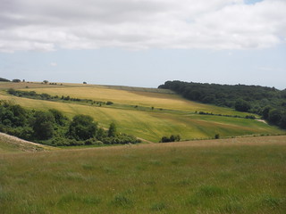
View from Westburton Hill
SWC Walk 217 Midhurst Way: Arundel to Midhurst
Jul-15 • thomasgrabow on Flickr
walkicon swcwalks swcwalk217 19443292861

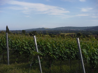
Upperton Vineyard with South Downs
SWC Walk 217 Midhurst Way: Arundel to Midhurst
Jul-15 • thomasgrabow on Flickr
walkicon swcwalks swcwalk217 19443883301

1000 year old Queen Elizabeth Oak
SWC Walk 217 Midhurst Way: Arundel to Midhurst
Jul-15 • thomasgrabow on Flickr
walkicon swcwalks swcwalk217 19252122778

Cowdray Castle
SWC Walk 217 Midhurst Way: Arundel to Midhurst
Jul-15 • thomasgrabow on Flickr
walkicon swcwalks swcwalk217 19251390028
| Length | 31.8 km (19.8 mi), with 640/623m ascent/descent. For a shorter walk see below Walk Options. |
|---|---|
| Toughness | 8 out of 10, 7 ¾ hours walking time. For the whole outing, including trains, sights and meals, allow at least 12 ½ hours. |
| Walk Notes |
The route leads through Arundel’s picturesque centre into a series of woods and heathlands to the highest point of the walk in Houghton Forest before crossing the South Downs Way near Westburton Hill. Surrounded by wooded downs you continue through the sleepy villages of West Burton and Bignor to lunch in Sutton and on to Barlavington, from where you descend into the Rother Valley through Burton Park with its pretty church and imposing mansion.
This walk is the southerly section of the unmarked Midhurst Way, which has been created by John Trueman, local to the area and a passionate advocate of outdoor pursuits. It runs between Arundel and Haslemere. The northerly section Midhurst to Haslemere is available as a separate SWC Walk.
|
| Walk Options |
Bus 99 Chichester - Petworth (6 buses per day, Mon-Sat) runs through Sutton, the lunch destination, and along the A285, enabling a finish at Duncton Heath End. This is a semi-flexible service, pre-booking is required: online via the Ride Pingo App or by calling 01243 858 854, 06.30-19.30 Mon-Sat! In Petworth you must connect to below Bus 1.
|
| Maps | OS Explorer: OL3 (Arundel & Pulborough) and OL33 (Haslemere & Petersfield)
|
| Travel |
Arundel Station, map reference TQ 024 264, is 79 km south west of Charing Cross and 4m above sea level. Midhurst, map reference SU 887 218, is 11 km south of Haslemere and 25m above sea level. Both are in West Sussex. Arundel station is on the Victoria to Southampton West Coastway Line. Journey times are from 84 minutes Mon-Sat (two trains an hour), and from 85 minutes on Sunday (hourly). Buses from Midhurst connect to Haslemere, Petersfield, Pulborough and Chichester. Bus 1 to Pulborough (on the same line as Arundel) runs hourly Mon-Sat and every two hours on Sundays. Saturday Walkers’ Club: Take a train no later than 9.00 hours. |
| Lunch and Tea |
The White Horse Inn The Street, Sutton, West Sussex RH20 1PS (01798 869 221). The White Horse is located 13.8 km (8.6 mi) into the walk.
|
| Midhurst |
Travel from Midhurst Updated Apr-25Catch a bus to/from a station, preferably on the same rail line you arrived from. If not possible, buy a more expensive ticket to Chichester, which is valid on both rail lines. Bus times change frequently. Check before you travel. Especially the time of the last bus! [2025] Bus fares are £3 (previous fares are shown in case the flat fare scheme ends)
There are 4 bus routes to choose from. Portsmouth Line from Waterloo to Haslemere or Petersfield
Arun Valley line from Victoria to Pulborough or Chichester
Both lines (a more expensive ticket to Chichester is needed, valid for all the above stations)
Taxi from Midhurst BJ's Private Hire (01730 716 327 or 07732 590 806). Uber is about £20 for Midhurst to Haslemere. |
|---|---|
| Profile | |
| Help Us! |
After the walk, please leave a comment, it really helps. Thanks! You can also upload photos to the SWC Group on Flickr (upload your photos) and videos to Youtube. This walk's tags are: |
| By Train |
Out (not a train station) Back (not a train station) |
| By Car |
Start Map Directions Finish Map Directions |
| Amazon | |
| Help |
National Rail: 03457 48 49 50 • Traveline (bus times): 0871 200 22 33 (12p/min) • TFL (London) : 0343 222 1234 |
| Version |
Oct-23 John Trueman Thomas G |
| Copyright | © Saturday Walkers Club. All Rights Reserved. No commercial use. No copying. No derivatives. Free with attribution for one time non-commercial use only. www.walkingclub.org.uk/site/license.shtml |
Walk Directions
Full directions for this walk are in a PDF file (link above) which you can print, or download on to a Kindle, tablet, or smartphone.
This is just the introduction. This walk's detailed directions are in a PDF available from wwww.walkingclub.org.uk
- Cross the A27 and head for the two single storey cottages on the north-west side of the roundabout between the A27 and the A284 London Rd and enter the restricted byway between the two cottages, signposted Chalk Springs Trout Farm.
- Walk through the mini industrial estate half a mile down - a media company and others - and continue up the track to a gate. From here take the footpath up the slope to the right for half a mile until you hit a rough stone track going north-west to south east.
- Turn left onto this flint track - see picture below entitled Rough - which runs along the contour, drops down into a valley and up a stiff slope the other side to a footpath sign indicating half left into the forest - the metalled track goes on. Shortly, the path becomes narrow and in places obstructed with broken yew tree branches. Keep going through the yew trees, most of which are on your left or westward side - the path is difficult to see here - and follow it down hill to where you hit a track with a single post right of way sign.
- It now becomes a stiff uphill walk until you hit a track with a signpost showing the path to be ahead (not down the track). Shortly after this you hit the crest. Go straight ahead and follow the path down the scarp to the earth and plank stairway.
- Cross the main A29 road and follow the track to The Denture.
- Turn off right at Barhale Wood and follow path to West Burton Hill.
- Thence through the wood and, finally, downhill to West Burton .
- Turn left at the junction of the track and the lane where there are several cottages and a stream.
- You may need to walk round standing corn as the path has not been left by the farmer. There is a way round the last field on its southern edge.
- Continue left on the lane at Bignor – the Roman Villa with its vineyard is in front of you across the lane.
- Bear right down the lane past Jay’s Farm and after a few hundred yards where you see a footpath sign to the left just in front of a cottage take the path down this valley past Bignor Mills and across the fields to Sutton.
- When you hit the lane at Sutton the White Horse pub is immediately ahead. Turn left through the pub car park and follow the footpath through the gardens of private houses, across the fields, and down the slope to a small wooded stream.
- Bear right up the meadow, across a style in a large hedge, turn sharp left along the track to Barlavington Farm.
- Turn left just before the farmyard and follow the path through the churchyard to the farm drive, continue down this a short way and follow the right of way sign west past an old yew tree, down the hill to the stream, across the lane, up the next hill – a field – to where it joins the lane again with views to Burton Park to the right (north-east).
- Continue around the big field with wood on your left, downhill past the pond and through the park to Burton Park Farm and thence to the next lane.
- Cross the road and go through the wood to Heath End.
- Turn right on to the busy main road – Petworth to Chichester – and follow the pavement (sidewalk) until you hit the old railway bridge. You get a good view eastwards to the Old Railway Station B&B with its Pullman carriages.
- Turn left immediately after the old bridge and follow the lane - a bridleway - to Rotherbridge, and cross the River Rother by the new bridleway bridge. Thence via a sunken track, Hunger Lane, through the sandstone bluff to the intersection with the next lane. Turn left to Sokenholes, Coxland Cottages and Tillington.
- Cross the main road – Midhurst to Petworth – into Tillington and turn sharp left after 50 yards up a rise into the village, following the lane to a churchyard entrance on the left after about 100 yards.
- Follow the path though the churchyard, turning sharp right at the avenue of trees, pass through the gate - see picture - cross the lane, and go up steps into a field.
- Continue across this field into the vineyard, across a deep, hidden old lane to Upperton Farm and thence up into more vineyards owned by Nyetimber.
- Cross New Road and follow the lane opposite – going north-west - to River via Dene Dip.
- Take the footpath left after the right hand bend down a tunnel of shrubs and trees to Eel Bridge over the River Lod. Cross Lodsworth Common (not marked) to St Peter’s Well, taking Vicarage Lane – to the right of the big house - up into the village.
- Turn right into The Street, after 100 yards turn left past the Hollist Arms in the direction of the Village Hall. Adjoining The Hollist Arms is the Lodsworth Larder, the village shop, crafted from local forest timber and stocked with local produce and run by volunteers.
- Continue down the lane to a sharp left hand bend at Heath End Farm, take the footpath ahead down the edge of the wood – Heathend Copse – round the field edge, across a broken style and into Cowdray Park, with views in every direction, through the Jubilee Avenue of 60 recently planted lime-trees celebrating the Queen's Diamond Jubilee thence downhill to Steward’s Pond.
- The 1000 year old Queen Elizabeth Oak is to the right of the pond, surrounded by other ancient trees covering the hillside.
- Continue past Steward's Pond on its southern edge, to the fence 50 yards ahead, pass through the swing gate, into a broad grassy way, bearing right, continue through the trees up the slope to where it breaks out on the fairway of Cowdray Golf Course.
- Cross over the golf course and down into another sunken pathway, finally crossing fields to The Race, an avenue of ancient chestnut trees.
- Turn left before The Race and follow the field margin to the main road at Easebourne – Midhurst to Petworth Road ; or follow The Race itself which is rougher going.
- Cross the main road and continue on a broad track, at first metalled, through Cowdray Park – the Cowdray Farm Shop & Café (Food Emporium) is on your right – to Cowdray Castle. Turn right through the gates over the River Rother and follow the Causeway to North Street Car Park, your finishing point.
- The South Downs National Park Authority new HQ, Capron House, is across the road (North Street) opposite the Bus Station


