Isle of Wight Coast Path : Lake to Ryde walk
The north east section of the coastal path: cliffs, Victorian promenades, and a quiet harbour.
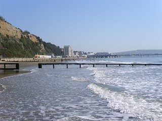
Sandown
aka Lake beach looking north
May-08 • Saturdaywalker on Flickr
swcwalks swcwalk71 banner 16517427122

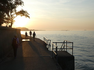

The original 1814 Ryde Pier, seen from the new walkway
Jul-23 • Saturdaywalker on Flickr
swcwalks swcwalk71 53141283933

The new walkway on Ryde Pier
Built on the former tram tracks
Jul-23 • Saturdaywalker on Flickr
swcwalks swcwalk71 53140215657
| Length |
Main Walk: 21 km (13 miles) if starting from Lake. Four hours 55 minutes walking time. For the whole excursion including trains, ferries, sights and meals, allow at least 12 hours. |
|---|---|
| OS Map |
Explorer OL29. Lake, map reference SZ590833, is on the Isle of Wight, 10 km SE of Newport. |
| Toughness |
4 out of 10. |
| Features |
This walk follows the Isle of Wight Coastal Path around the north-eastern corner of the island. The suggested starting point is Lake, the small station on the Island Line between Sandown and Shanklin which is conveniently close to the path, but you could also start from one of those stations. Between their busy Victorian promenades and Ryde the route varies from the cliffs of Culver Down to the quiet harbour at Bembridge and small seaside villages. There are good opportunities for swimming on this walk, eg. at Sandown Bay near the start. |
| Warning |
This is not an original walk and is not being regularly checked. Other walking guides to the IoW Coastal Path (eg. Sandown-Ryde) may have more up-to-date information. Conditions on coastal walks are particularly liable to change and you might need to divert off the route described here. |
| Walk Options |
Starting the walk from Sandown, the station before Lake, saves about 750m but it involves more road walking and you would miss the cliff-top views of Sandown Bay as you set off. At the end of the walk, you can save a similar distance by finishing the walk at Ryde Esplanade and taking the train out along the pier. More generally, you could make use of the frequent Southern Vectis buses to cut out one or more stages of the walk. |
| Transport |
The stations on the Island Line (Ryde Pier Head to Shanklin) are reached by Wightlink FastCat from Portsmouth Harbour, which is served by trains from Waterloo. A through ticket to any station on the line includes the ferry crossing. The complete outward journey takes about 2 hours 30 minutes. From Ryde Pier Head, the return journey is just over 2 hours; it gets longer in the late evening but this fairly long walk is still feasible as a day trip from London in the summer. |
| Suggested Train |
Take the train nearest to 09:00 from Waterloo to Portsmouth Harbour, then the ferry to Ryde Pier Head and the Island Line to Lake (IoW). |
| Train & Ferry Times |
|
| Timetables |
|
| Lunch |
The suggested place for a pub lunch or picnic (5¼ km from Lake) is on Culver Down, where there are panoramic views from the top of the cliffs and the Culver Haven Inn (01983-406107; closed Mon & Tue) serves food until 2.15pm. 3 km further on at Bembridge, the up-market Crab and Lobster Inn (01983-872244) has a fine coastal location overlooking Bembridge Ledge. |
| Tea |
At Bembridge Pier there is a nice café, the Lifeboat View (01983-875568), although this is less than halfway through the full walk. There are several more seafront cafés in the second half of the walk, and many pubs and eateries in Ryde at the end. |
| Profile | |
|---|---|
| Help Us! |
After the walk, please leave a comment, it really helps. Thanks! You can also upload photos to the SWC Group on Flickr (upload your photos) and videos to Youtube. This walk's tags are: |
| By Train |
Out (not a train station) Back (not a train station) |
| By Car |
Start PO36 8PJ Map Directions Return to the start: Finish PO33 2HF Map Directions Travel to the start: |
| Amazon | |
| Help |
National Rail: 03457 48 49 50 • Traveline (bus times): 0871 200 22 33 (12p/min) • TFL (London) : 0343 222 1234 |
| Version |
Feb-23 Sean |
| Copyright | © Saturday Walkers Club. All Rights Reserved. No commercial use. No copying. No derivatives. Free with attribution for one time non-commercial use only. www.walkingclub.org.uk/site/license.shtml |

Walk Directions
Click the heading below to show/hide the walk route.


 Walk Map
©
Walk Directions
Click on any section heading to switch between detailed directions and an outline, or the heading above to switch all sections.
- The Island Line to Sandown Bay (¾ • 1½ • 3½ km)
-

 Make your way from any of the three stations at the end of the Island Line onto the Coastal Path. Follow it northwards to Sandown Bay.
-
Starting from Sandown Station (¾ km)
-
There are many routes from the station down to the sea. A straightforward route (which comes out 300m past the pier) is to start by heading E along Station Avenue. In 250m go straight across the A3055.
-
In a further 400m turn right at the T-junction with Albert Road. Follow this round to the left, go across the High Street and turn left onto the Esplanade.
-
Starting from Lake Station (1½ km)
- Go down the ramp from the platform and turn right. Take the signposted footpath on the left, which in 100m comes to the Coastal Path at the top of the cliffs. Turn left and follow it for 800m into Sandown.
-
At Ferncliff Gardens go down a flight of steps and turn right at the bottom to go down a steep path. Turn left onto the Esplanade and continue along it for 500m, passing the pier.
-
Starting from Shanklin Station (3½ km)
-
Take the left-hand of the two roads leading away from the railway station (Atherley Road), heading E. In 350m go straight across the A3055 into Hope Road.
- In 250m, before this road curves down to the beach, turn left into Delphi Road and go uphill to the Coastal Path. Follow the undulating cliff-top path for 2¼ km into Sandown.
- …
- Sandown Bay to Culver Down (3¾ km)
- Continue along the Esplanade. At Yaverland, the Coastal Path leaves the sea front to ascend Culver Down. Aim for the prominent monument at the top of the Down.
- Continue along the Esplanade for a further 1¼ km, heading NE. After passing the Zoo go through the car park at Yaverland beach onto a footpath, signposted to Culver Down.
- Follow the path uphill for 2 km, aiming for the large obelisk at the top of Bembridge Down. As you approach it, bear left to go diagonally up a field to reach the Yarborough Monument?. Go past it onto a lane to reach the Culver Haven Inn, the suggested lunch stop.
- Culver Down to Bembridge Pier (4 km)
- Go down a path behind the Culver Haven Inn and continue on a cliff-top path above Whitecliff Bay and Black Rock to Foreland Fields. You may be able to continue along the shoreline around Foreland to Bembridge Pier, but the official path turns inland here.
- Make your way onto a path behind the pub which heads NE from the monument diagonally across a field. In the far corner of the field, continue down a steep chalky path which leads to a wooded area above Whitecliff Bay.
- Follow the Coastal Path signs along the cliff top for 2½ km, ignoring paths leading steeply down to the beach. You pass holiday chalets and school playing fields and continue along the right-hand side of Foreland Fields.
-
Go through a small car park and continue on the narrow coastal path between two houses and the sea. Turn left through its car park to come to the Crab and Lobster Inn (the alternative lunch stop).
The official Coastal Path now turns inland for 1 km (as described below), although the OS map shows a public footpath along the shoreline around Foreland. If you are tempted to follow this route, check the tide and consult local notices.
- For the official route, turn right past the Coastguard Lookout and then left into Beachfield Road. In 250m, at the end of this road, turn right into Howgate Road and take the second turning on the left, Forelands Farm Lane.
- In 75m turn right onto a footpath. At the end of the path, continue past a hotel and turn left onto Fishermans Walk, rejoining the shoreline route. This goes past Bembridge Pier? (with the Lifeboat Station at the end) and then the Lifeboat View café, a possible early tea place.
- Bembridge Pier to The Duver (4¼ km)
- Go along the sea wall and continue along the shoreline to Bembridge Point (or detour inland at high tide). Follow the B3395 around Bembridge Harbour. On the other side of the River Yar, turn right and go along a causeway to The Duver.
- From the pier continue along the sea wall or shoreline for 500m, where there is a footpath off to the left.
-
Shoreline route via Bembridge Point
- If it is safe to do so, continue along the shoreline for about 750m. Unless you want to try to go all the way round Bembridge Point, take a path inland to Ducie Avenue. Turn right onto a footpath leading to Pump Lane and then the B3395.
-
Inland detour to Bembridge Harbour
- Take the footpath inland. In 250m turn right onto a path which leads into Love Lane. Where this road turns sharply left, keep ahead on a footpath which crosses Ducie Avenue and comes out on a bend of the B3395.
-
Turn right onto the B3395 (Embankment Road?). Unless an enterprising person is offering ferry trips across the mouth of the River Yar to The Duver, you will have to follow this road for 1½ km as it sweeps around Bembridge Harbour and its boatyards.
If you want to finish the walk here, buses to Ryde go along this road.
- Just after crossing the bridge over the River Yar, turn sharp right into Latimer Road. Where this road turns left in 150m, turn right and follow a minor road round to the converted St Helens Mill. Go past this onto a footpath along a causeway?.
- At the end of the causeway, continue in the same direction across an open area, The Duver?. Bear left onto a lane towards the ruins of St Helen's Old Church?.
- The Duver to Seaview (3 km)
- For the next 2 km the official Coastal Path goes inland to Seagrove Bay, but except at high tide it is possible to stay close to the shoreline if you are prepared to scramble over large rocks at Horestone Point. From Seagrove Bay continue along Pier Road to Seaview.
-
Inland route on Coastal Path
- Stay on the lane as it passes to the left of Old Church Lodge. Cross a stile onto a footpath with a hedge on your right.
- In 300m, bear right across some scrub and a field to reach a driveway. Turn right onto it and head N towards the Priory Bay Hotel?.
- In 250m, having ignored a turning on the right to a holiday centre, bear left onto a tree-lined bridleway in front of the hotel grounds. In 300m this ends at a track, where you turn right.
- In 400m the track bends left and leads into Fernclose Road. Follow this road down towards Seagrove Bay, where it bends right and meets the Esplanade. Turn left here onto a public footpath.
-
Shoreline route via Horestone Point
- Bear right off the lane to pass the Old Church. Continue along the shoreline for a short distance, then take a path on the left which runs along the edge of a wood, close to the shore.
- In 500m, the path bends left at Node's Point and continues to wind through the wood for another 500m, now with Priory Bay (a private beach) below on your right.
- The path eventually drops down to a public beach. Turn left towards Horestone Point, where you will have to scramble over large rocks to get to the Esplanade on Seagrove Bay.
- Follow this road for 200m, where it bends left and meets Fernclose Road. Turn right here onto a public footpath.
- The footpath soon leads into Pier Road and you follow this for 750m into Seaview. At a junction turn right onto the High Street. Follow it round to the left at Nettlestone Point and onto the sea wall.
- Seaview to Ryde Pier Head (4½ km)
-
 Continue along the sea wall and coast roads to Ryde Pier. You can either walk out to the ferry terminal or take the train along the pier.
-
For the final section, simply continue along the sea wall and coast roads where necessary. After going around Puckpool Point you pass Appley Tower? and continue into Ryde.
- At Ryde Pavilion move inland onto the Esplanade and continue up to the bus station in front of Ryde Pier.
-
Make your way onto the passenger walkway leading to the ferry terminal at the far end of the pier.
-
Alternatively, take the train from Ryde Esplanade station to cut out the final 750m along the pier.
-
Alternatively, take the train from Ryde Esplanade station to cut out the final 750m along the pier.
- The Yarborough Monument was erected by the Royal Yacht Squadron in 1849 to commemorate their first Commodore.
- Bembridge Pier was built by the RNLI in 1922 so that the boathouse could be repositioned from the shore, enabling the lifeboat to be launched over the rocky ledges at any tide.
- As its name suggests, Embankment Road around Bembridge Harbour is a causeway, constructed in 1878 to link the villages of Bembridge and St Helens. The original port on the River Yar was at Brading, 4 km inland.
- This causeway was the old Mill Dam Wall, separating the mill ponds from the harbour.
- The sandy common called The Duver was the site of the Isle of Wight's first golf course. It is now maintained by the National Trust.
- St Helen's Old Church dates from 1080 but had been abandoned as unsafe before it was destroyed by a great wave in 1720. The seaward side of the tower is painted as a seamark – reputedly Nelson's last view of England before sailing for Cadiz and the Battle of Trafalgar. The sandstone blocks from the ruined church may have been the original ‘holystones’ used by seamen for scrubbing the decks.
- The Priory Bay Hotel is on the site of a Cluniac priory, established by Benedictine monks soon after the Norman Conquest.
- Appley Tower is a typical Victorian landmark, built at the end of the 19thC.
You can start the walk from any of the three stations at the end of the Island Line. The middle of the three (Lake) is the closest to the Coastal Path.
The official Coastal Path in [?] continues along the shoreline, but if it is high tide you will have to follow the inland detour in [?].
For the next 2 km the official Coastal Path in [?] goes inland, but except at high tide it is possible to take the shoreline route in [?] if you are prepared to scramble over large rocks at Horestone Point.
Walk Notes
» Last updated: September 21, 2020
Return to Top | Walk Map | Walk Directions.