Yarmouth Circular walk
The Isle of Wight coastal path, Tennyson Down, a nature reserve, and a disused railway.

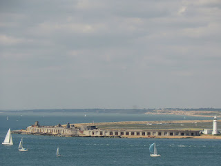
CIMG8212
Hurst Castle across the Solent
Jul-13 • Sean O'Neill
swcwalk72, swcwalks 5903126913615347890 P

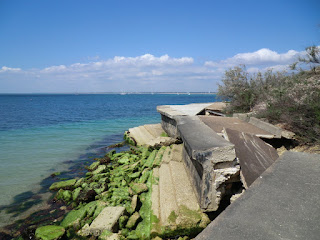
CIMG8217
A tricky section of the Coastal Path
Jul-13 • Sean O'Neill
swcwalk72, swcwalks 5903127034687509218 P


| Length |
Main Walk: 19¼ km (12 miles). Four hours 40 minutes walking time. For the whole excursion including trains, ferries, sights and meals, allow at least 13 hours. |
|---|---|
| OS Map |
Explorer OL29. Yarmouth, map reference SZ354898, is on the Isle of Wight, 15 km W of Newport. |
| Toughness |
5 out of 10. |
| Features |
This walk follows the Isle of Wight Coastal Path from Yarmouth to Alum Bay, then along Tennyson Down to Freshwater Bay. Leaving the Coastal Path, the route turns north through Afton Marsh Nature Reserve and returns to Yarmouth via a disused railway line along the Yar estuary. Swimming may be possible at Colwell Bay and Totland Bay, in the first part of the walk. |
| Warning |
This is not an original walk and is not being regularly checked. Other walking guides to the IoW Coastal Path (eg. Yarmouth-Brighstone) and the inland section may have more up-to-date information. Conditions on coastal walks are particularly liable to change and you might need to divert off the route described here. |
| Walk Options |
The walk notes include a short cut of 1½ km at the westernmost end of the island, although that misses out some fine views. More generally, you could make use of the frequent Southern Vectis buses to cut out the start or finish of the walk, eg. by taking the #7 from Yarmouth to start at Colwell Bay, or diverting into Freshwater to take it from there back to Yarmouth. |
| Transport |
Yarmouth is reached by Wightlink ferry from Lymington Pier, which is served by trains from Waterloo (changing at Brockenhurst). A through ticket to Yarmouth (IoW) includes the ferry crossing. The complete journey takes about 3 hours, so this is at the limit of what is feasible for a day trip from London. |
| Suggested Train |
Take the train nearest to 09:00 from Waterloo to Lymington Pier, changing at Brockenhurst, then the ferry to Yarmouth (IoW). |
| Train & Ferry Times |
|
| Timetables |
|
| Lunch |
The suggested place to stop for lunch is Totland Bay, after 5½ km. The Waterfront Bar & Restaurant (01983-756969) serves bar food throughout the day, and there are other bars and cafés along the seafront (the Captain's Cabin, The Hut). You could also eat in one of the tourist places at Alum Bay an hour further on. |
| Tea |
Almost anywhere along the Coastal Path you might find an enterprising owner offering cream teas. The crowded tourist places at Alum Bay might not appeal, but the short cut omitting the Needles goes past Warren Farm's Tea Garden (01983-753200; open to 4.30pm Thu-Sun & BH Mon, summer only). Conversely, if you take the detour to Needles Old Battery there is a 1940s-themed National Trust tearoom (01983-754772; open to 5pm daily summer, 3pm weekends only in winter) at the site. At Freshwater Bay the options by the beach are uninspiring but a short detour will take you to a good tearoom in the Dimbola Museum (01983-756814; open daily to 4pm). At the end of the walk in Yarmouth there are several pubs near the ferry terminal. The George Hotel (01983-760331) in Quay Street has a waterfront terrace and the Bugle Coaching Inn (01983-760272) in The Square has a nice courtyard. Refreshments are also available on the ferry. |
| Profile | |
|---|---|
| Help Us! |
After the walk, please leave a comment, it really helps. Thanks! You can also upload photos to the SWC Group on Flickr (upload your photos) and videos to Youtube. This walk's tags are: |
| By Car |
Start Yarmouth Ferry Terminal, Isle of White Map Directions |
| Amazon | |
| Help |
National Rail: 03457 48 49 50 • Traveline (bus times): 0871 200 22 33 (12p/min) • TFL (London) : 0343 222 1234 |
| Version |
Feb-23 Sean |
| Copyright | © Saturday Walkers Club. All Rights Reserved. No commercial use. No copying. No derivatives. Free with attribution for one time non-commercial use only. www.walkingclub.org.uk/site/license.shtml |


Walk Directions
Click the heading below to show/hide the walk route.


 Walk Map
©
Walk Directions
Click on any section heading to switch between detailed directions and an outline, or the heading above to switch all sections.
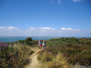
- Yarmouth to Totland Bay (5½ km)
- Take the Coastal Path heading west out of Yarmouth, through Fort Victoria Country Park to Colwell Bay and Totland Bay. Except at high tide, you should be able to walk along the beach at Colwell Bay and so avoid a detour inland.
- From the ferry terminal, with Yarmouth Castle? on the left, go straight on alongside the harbour. At the end turn right onto the main road (the A3054) to cross the River Yar. 400m from Yar Bridge, where the A3054 turns left, turn right onto a path going down to the sea.
- Turn left to go along the sea wall for 400m, then turn left onto a short path going up through the trees to a lane. Turn right along this for 100m, then bear left onto a track? through the woods. Continue SW through Fort Victoria Country Park for 1¼ km to Cliff End Battery, with a fine view across the Solent to Hurst Castle?.
- After leaving the woods continue on an enclosed path which comes out onto Monks Lane. Turn left, then in 500m turn right at a junction and keep ahead into a holiday camp. Go through this and take the signposted Coastal Path on the left, passing chalets and later going between hedges to come out onto a lane.
-
Suggested route
-
Turn right onto the lane to go down to Colwell Bay (the monstrous building on the coastline to the right is Fort Albert?). If conditions permit, turn left and go along the path by the beach for 500m to rejoin the official Coastal Path.
- This route might not be feasible at high tide, or after cliff falls. If you are not completely sure about it, return up the lane and take the inland route in [?].
-
Inland route on Coastal Path (+¾ km)
- Go up the lane, as signposted for the Coastal Path. Go past Brambles Farm and turn right onto the A3054. After 450m along the main road turn right into Colwell Chine Road. Follow it down to the sea wall and turn left.
- Follow the Coastal Path around Warden Point to reach the pier in Totland Bay. There are several refreshment places on the seafront, including the prominent Waterfront Bar & Restaurant.
- Totland Bay to Alum Bay (3¼ km)
- Continue on the Coastal Path, which leaves the sea front to climb over Headon Warren. On the other side, descend into Alum Bay and go through The Needles Park onto West High Down.
- Continue S on the Coastal Path. 500m from the Waterfront Bar, just after passing the old lifeboat house, turn left up steps. Go through Widdick Chine to Cliff Road and turn right.
- Follow the road uphill as it curves round to the right. 200m along the road, where it bends left, turn right onto a signposted footpath. After winding through trees for 400m, the path emerges onto Headon Hill.
-
Go uphill on a wide grassy path, taking the right fork to pass beneath the summit.
- There are several alternative paths through the gorse and heather on Headon Warren. For example, you could go along the ridge at the top where there are bronze age tumuli. You would be able to see Alum Bay ahead and should be able to pick up the main route.
- The official route continues W below the summit on a roughly level path. After a path comes down from the summit, bear left to go steeply downhill. At the bottom of the slope the path turns left and zig-zags down to a driveway, where you turn left to reach the B3322.
- Turn right onto the road and in 150m turn left into The Needles Park at Alum Bay. Make your way through the scrum as best you can and keep ahead on a tarmac lane onto West High Down.
- Alum Bay to Freshwater Bay (5½ km)
- Follow the lane up to the top of the down by Coastguard Cottages, with an optional extension to the Old Battery and The Needles viewpoint. Turn round and head east to reach Tennyson Down, passing Tennyson's Monument and descending to Freshwater Bay.
-
Follow the tarmac lane round to the right as it climbs up the downs, with views back to Alum Bay?.
- Alternatively, you could take the footpath off to the left at this bend. This goes along the side of the down for 1 km (passing a gate on the left leading down to Warren Farm's Tea Garden), then bears right uphill towards the Tennyson Monument. If you take this short cut (saving about 1½ km), resume the directions at [?].
-
In 600m there is a stile and path on the left leading up to Coastguard Cottages. Unless you want to extend the walk to visit the Needles Old Battery or its tearoom, bear left onto this path towards the cottages.
- The Needles Old Battery? is a further 600m along the lane. On the way back, you can take a path on the right leading up to the New Battery and Coastguard Cottages to rejoin the main route.
- The Coastal Path veers sharply left in front of the cluster of buildings on the headland, but it is worth crossing a stile and detouring a short distance ahead to the Marconi Monument?, the Needles New Battery? and The Needles? viewpoint.
- The main route now simply heads E along the ridge towards the prominent Tennyson Monument. In 2 km you come to a major path crossing in a dip (where the short cut route merges from the left) and turn half-right.
- Go up Tennyson Down to reach the Tennyson Monument? in 600m. Go past it and continue gently downhill in the same direction for 1½ km.
-
Leave Tennyson Down over a stile and bear left across a field. At the bottom of the field turn left onto a track and go up to a road (Gate Lane). Unless you want to visit the Dimbola Museum or its tearoom, turn right onto this road.
- The Dimbola Museum? is 250m along the road to the left.
- Go along Gate Lane towards the seafront, 100m away. Unless you want to visit the tearoom ahead on the left, or the Albion Hotel opposite, turn left just before these places into Coastguard Lane.
- Freshwater Bay to Yarmouth (5 km)
-
 From the western end of Freshwater Bay, head north on the Freshwater Way through Afton Marsh Nature Reserve. At a road, turn right to leave this route, then turn left onto a permissive path through the northern part of the reserve. At Afton Road go onto a disused railway line and follow this all the way back to Yarmouth, eventually bearing left past an old tide mill into the town centre.
- Leave Freshwater Bay on Coastguard Lane, heading N on the Freshwater Way? (FW). At the end of the lane, keep ahead on a footpath through Afton Marsh Nature Reserve. Shortly after going through a gate, fork right and follow the path out to a road.
- Turn right onto the road for a short distance, leaving the FW. Just before a bridge, turn left onto a path into the northern part of the reserve, with a stream on your right. The path soon crosses it on a footbridge and you continue along its other side for a further 500m to the A3055.
-
Turn left onto the road and in 50m turn right onto a bridleway. This soon turns right onto the track of a disused railway line?, initially heading E and later curving gradually to the left.
- In 400m cross a minor road to continue on a cycleway, now with the River Yar on your left. In 2¼ km you come to a path crossing on the outskirts of Yarmouth.
- Turn half-left to head N towards a three-storey brick building, Yarmouth Mill?. After passing it, bear left onto Mill Road. In 200m cross the A3054 to continue on St James' Street.
-
The town centre is 150m further on. At the end of this street the Bugle Coaching Inn is on the right and the George Hotel is on Quay Street to the left, which leads to the ferry terminal.
- Yarmouth Castle was one of a chain of castles built by Henry Ⅷ to guard against a French invasion.
- The track is an old military road built to serve two 19thC forts guarding the Solent: Fort Victoria (behind the trees on the right) and Fort Albert (visible from Colwell Bay).
- Hurst Castle (on the mainland) was another of Henry Ⅷ's protective forts.
- Fort Albert was used at one time for torpedo testing, though sadly not as the target.
- The famous cliffs of Alum Bay, which come into view as you climb West High Down, are made of sandstone coloured by a variety of different minerals.
- Needles Old Battery (NT) contains exhibitions about its involvement in both World Wars. It was built in 1862, following the threat of a French invasion.
- Guglielmo Marconi made experimental wireless transmissions from the Royal Needles Hotel at Alum Bay in 1897.
- Needles New Battery (NT) contains an exhibition on Britain's secret rocket testing during the Cold War.
- The chalk pinnacles of The Needles are gradually being eroded by the sea (one collapsed in 1764). The lighthouse was built in 1858.
- The poet Alfred Lord Tennyson lived at Farringford House in Freshwater for 40 years.
- The Dimbola Museum is dedicated to the life and work of the Victorian photographer Julia Margaret Cameron.
- The Freshwater Way runs for 6 km across the western end of the island, from Freshwater Bay to Yarmouth.
- The disused railway line was the only one in the western half of the island, running from Newport through Yarmouth to Freshwater.
- Yarmouth Mill is an old tide mill.
The suggested continuation if conditions permit is to take the beach route in [?] instead of the official route.
Walk Notes
» Last updated: September 21, 2020
Return to Top | Walk Map | Walk Directions.