Pen Y Fan and Corn Du from Storey Arms Walk
A classic, and very popular, short walk climbing up to the two highest peaks in the Brecon Beacons along an engineered path.

Corn Du and Pen y Fan, from Craig Gwaun Taf
SWC Walk 85 - Pen Y Fan and Corn Du from Storey Arms
Jul-22 • thomasgrabow on Flickr
swcwalks swcwalk85 banner 52203593200
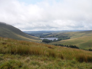
Beacons Reservoir sideview
SWC Walk 85 - Pen Y Fan and Corn Du from Storey Arms
Jul-22 • thomasgrabow on Flickr
swcwalks swcwalk85 walkicon 52203591690
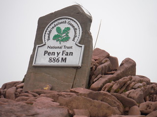
NT sign on top of Pen y Fan
SWC Walk 85 - Pen Y Fan and Corn Du from Storey Arms
Jul-22 • thomasgrabow on Flickr
swcwalks swcwalk85 walkicon 52202088032

View from Pen y Fan to Cribyn and into the Cwm Sere
SWC Walk 85 - Pen Y Fan and Corn Du from Storey Arms
Jul-22 • thomasgrabow on Flickr
swcwalks swcwalk85 walkicon 52202088297

Backview from initial ascent to Fan Fawr
SWC Walk 85 - Pen Y Fan and Corn Du from Storey Arms
Jul-22 • thomasgrabow on Flickr
swcwalks swcwalk85 52202086567
| Length |
7.6 km (4.7 mi) with 540 m of ascent |
|---|---|
| Toughness | 3 out of 10 |
| Features |
This classic short walk is to the summit of Pen y Fan (886m), the highest peak in South Britain and the Breacon Beacons National Park. It is very popular, especially on sunny weekends. It involves a steep climb at the start to reach the ridge, but then continues fairly gentle on good paths for a short but very scenic section along a U-shaped ridge around a steep sided glacial valley, with stunning views over South Wales, and the Bristol Channel. From Pen y Fan you walk back to the second prominent top, Corn Du, with fantastic views down into the Cwm Llwch (valley) with its scenic lake. Form there descend on a different route along a less populated route involving a minor re-ascent to the car park by the Storey Arms Outdoor Centre on the A470 and make your way back along the road. The entire route is over well maintained paths, the drops are steep only on 1 side, so none of it is scary, or needs a head for heights. Route finding (in clear weather) is easy. The summits are very exposed however, so this is a walk for a clear sunny day, with little wind or rain. Pen y Fan is large glacial grassy mound with steep glacial sides, less rocky than the mountains of North Wales. It is the southern most mountain in Great Britain, about 3½ hours drive from London. The Storey Arms (no longer a pub) car parks on the A470 can be reached by car, or regular bus (Cardiff - Merthyr - Storey Arms - Brecon). This is the 'easy' ascent. For a walk along the full Brecon Beacons Horseshoe including all four of the table top peaks, see SWC Walk 278 Brecon Beacons Horsehoe, which starts from the Neuadd Reservoir access road (car only), but has several access options utilising public transport. |
| Walk Options |
|
| Links |
|
| Maps |
OS Explorer: OL12 (Breacon Beacons National Park)
|
| Travel |
By Car: Pont ar Daf National Trust Car Park on the A470, just south of the Storey Arms Outdoor Centre, or car park right by the Storey Arms Outdoor Centre. By Public Transport: Storey Arms Bus Stop is on line T4 (Cardiff - Pontypridd – Merthyr Tydfil – Brecon – Newtown), with 11 buses a day Mon-Sat and 6 on Sundays and Bank Holidays. Merthyr Tydfil is the closest train station. From there, catch the T4 bus. |
| Stay | Accommodation is available in Brecon, Merthyr Tydfil, Crickhowell and Abergavenny, as well as in the Llwyn-y-Celyn Youth Hostel south of Libanus. |
| Lunch and Tea | Kiosks selling hot drinks and snacks in both of the car parks, by the Storey Arms and at Pont ar Daf.
The Tai'r Bull Inn in Libanus (north along the A470), open all day Wed-Sun. |
| Brecon Beacons/Bannau Brycheiniog |
The Brecon Beacons/Bannau Brycheiniog National Park is in south Wales. It consists of bare, grassy, glacial mountains, with north facing escarpments. Its peaks, just shy of 1,000m (3,000ft), are the highest mountains in the southern UK. The national park is also noted for reservoirs, and the Dan yr Ogof caves. Its 4 mountain areas, from west to east are:
|
|---|---|
| Mountain Safety |
This is a challenging but achievable walk in good weather, even for young children, but it is in remote exposed mountain areas. It is possible to twist an ankle on any walk, and it will take hours for mountain rescue to drive to the trailhead, then climb the mountain, to reach you. So:
|
| Welsh Glossary |
aber: estuary, confluence, river mouth; afon: river; affwys: abyss; allt: hillside, cliff; aran: high place; ban/fan/bannau (pl): peak/beacon/crest, hill/mountain; big: peak; blaen: source of river, head of valley; bod: dwelling; bre: hill; bron: hill-breast; bryn: hill; bwlch: gap/col/pass; cadair: chair; cae: field; caer/gaer: stronghold, fort; capel: chapel; carn/garn/carnedd/garnedd: cairn, heap of stones, tumulus; carreg/garreg: stone, rock; castell: castle; cefn: ridge, hillside; celli: grove/copse; cerwyn: pot-hole; cist: chest; clog/clogwyn: cliff; clun: meadow; clwyd: hurdle/gate; clydach: torrent; coch/goch: red; coed: wood; craig/graig: rock; crib/cribyn: crest, ridge, summit; crug: mound; cul: narrow; cwm: hanging valley/corrie/bowl/dale; cyfrwy: ridge between two summits (saddle); ddinas: fort; dibyn: steep slope, precipice; dim: no; din: hill-fortress; disgwylfa: place of observation, look-out point; dôl: meadow; du/ddu: black, dark; dwfr/dŵr: water; dyffryn: valley; -dyn: fortified enclosure; eglwys: church; eira: snow; eisteddfod: meeting-place, assembly; esgair: ridge; fach/bach: small; fawr/mawr: large; fechan: smaller; ffald: sheep-fold, pound, pen, run; ffordd: way, road; ffridd: pasture; ffrwd: stream, torrent; ffynnon: spring/well; gallt: wooded hill; ganol: middle; garth: promontory, hill, enclosure; glan/lan: river-bank, hillock; glas: green (when referring to grass, pasture or leaves), blue (when relating to the sea or air); glyn: deep valley, glen; gors: bog; gorsedd: tumulus, barrow, hillock; gwyddfa: mound, tumulus; gwylfa: look-out point; gwyn/gwen: white; gwynt: wind; hafn: gorge, ravine; hafod: summer dwelling; hen: old; hendre(f): winter dwelling, old home, permanent abode; heol: road; hesgyn: bog; hir: long; is: below, lower; isaf: lower/lowest; llan: church, monastery; llawr: level area, floor of valley; llech: slab, stone, rock; llther: slope; lluest: shieling, cottage, hut; llwch: lake, dust; llwybr: path; llwyd: grey, brown; llwyn: bush, grove; llyn: lake; llynwyn: pool/puddle, moat; maen: stone; maes: open field, plain; mawn: peat; mawnog: peat-bog; melyn: yellow; merthyr: burial place, church; moel/foel: bare, bald/bare hill; mynydd: mountain, moorland; nant: brook/stream, dingle/glen; neuadd: hall; newydd: new; ogof/gogof: cave; pant: hollow; parc: park, field, enclosure; pen: head, top/end, edge; penrhyn: promontory; pentre(f): homestead, village; perfedd: middle; perth: bush, brake, hedge; plas: hall, mansion; pont/bont: bridge; porth: gate/gateway, harbour/bay/landing-place/ferry; pwll: pit, pool; rhiw: hill, slope; rhos: moor, promontory; rhudd: red, crimson; rhyd: ford; sarn: causeway; sgwd/rhaeadr: waterfall; sticill: stile; sych: dry; tafarn: tavern; tâl: end, top; talar: headland (of field); tan/dan: below; tarren/darren: escarpment; tir: land, territory; tor: break, gap; tre/tref: settlement, hamlet, town; twlch: tump, knoll; twll: hole, pit; tŵr: tower; twyn: hill; tŷ: house; uchaf: upper, highest; uwch: above, over; waun/gwaun: moorland, meadow; wen/wyn: white; y, yr, ‘r: the; ynys: island, holm, river-meadow; ysgol: ladder, formation on mountain-side/school; ysgwydd: shoulder (of mountain); ystafell: chamber, hiding-place; ystrad: wide valley, holm, river-meadow. |
| Profile | |
| Help Us! |
After the walk, please leave a comment, it really helps. Thanks! You can also upload photos to the SWC Group on Flickr (upload your photos) and videos to Youtube. This walk's tags are: |
| By Car |
Start Map Directions |
| Amazon | |
| Help |
National Rail: 03457 48 49 50 • Traveline (bus times): 0871 200 22 33 (12p/min) • TFL (London) : 0343 222 1234 |
| Version | |
| Copyright | © Saturday Walkers Club. All Rights Reserved. No commercial use. No copying. No derivatives. Free with attribution for one time non-commercial use only. www.walkingclub.org.uk/site/license.shtml |


Walk Directions
Starting from the Pont ar Daf National Trust Car Park just south of the Storey Arms Outdoor Centre
- From the southerly end of the car park go through a wooden gate to the right of a wooden field gate and ford or cross on a two-railed footbridge the Blaen Taf Fawr (stream) to ascend up a broad engineered path.
- Continue all the way to the Bwlch Duwynt (‘Windy Pass’ in English) at the top of the rise, at 815m above sea, in 2.2 km.
- You are on a steep, horse-shoe shaped, escarpment, at a T-junction with a path running along it from Craig Gwaun Taf on the right.
- On the left and in front are the four renowned table-top peaks of the Central Brecon Beacons (l-t-r): Corn Du, Pen y Fan, Cribyn and Fan y Big.
- Further right is the large upland bog of Waun Rydd and in the valley inbetween the two (disused) Neuadd Reservoirs, with the Taf Fechan Forest further along to the right and the Pentwyn Reservoir beyond it.
- To the left the path forks. Follow the right fork in the direction of Pen y Fan 900m away. In 600m, in a saddle, a path joins from the left from Corn Du, as you begin the final ascent to Pen y Fan.
- You reach the cairned summit of Pen y Fan (‘Head of the Place’ in English, at 886m above sea the highest top in the Brecon Beacons and South Britain) in 300m. The cairn on the summit was a Bronze Age burial chamber (when it was excavated in 1991 a bronze brooch and spearhead were found inside the chamber).
- Brecon can be seen to the north and on a good day Cadair Idris is just about visible. To the east you can make out the Black Mountains and the distinctively shaped ‘Sugarloaf/Pen y Fâl’ hill between Crickhowell and Abergavenny, and to the south-west the Bristol Channel.
- Retrace your steps to the saddle between Pen y Fan and Corn Du and fork right there to ascend Corn Du (‘Black Horn’ in English), whose cairned top (at 873m above sea) you reach in 300m. The cairn on the summit was a Bronze Age burial chamber. From here you have stunning views into the Cwm Llwch with its scenic lake.
- For the shortest return route: bear left to descend back to the Bwlch Duwynt (saddle) and retrace your steps back to the start along the engineered path.
- Else bear right to find the - initially - rocky descent from Corn Du along the rim of the escarpment (the Craig Cwm LLwch) and in 300m [!] turn left along a clear engineered path away from the rim (265°).
- In 1.2 km you ford a stream (the Blaen Taf Fawr) at the bottom of a broad saddle and re-ascend up to Y Gyrn, staying to the left of its rounded top in 500m.
- A steep descent from its plateau then leads you in 600m to the corner of a wood above the A470 and you continue in the same direction to the right of the wood to reach the road to the right of the Storey Arms Outdoor Centre in another 280m.
- Cross the A470 into the car park opposite, where there is usually a kiosk selling hot drinks and snacks. Turn left, either along the grassy road verge in a south easterly direction and in 400m you can cross the road to enter the Pont ar Daf car park, or turn left through a wooden gate to follow a more sheltered path at the bottom of the wood on the left, parallel to the road.
Starting from the car park right by the Storey Arms Outdoor Centre
- With the A-road in your back, walk through a wooden kissing gate to the left of a wooden field gate and up an engineered path to the left of the Storey Arms Outdoor Centre (30°), signposted ‘Pen Y Fan’, initially with a wooded area on the right, to continue in the same direction in 280m at the corner of that wood, still uphill.
- You get some views of Brecon Reservoir behind on the right in the valley below, and in 600m the terrain levels out for a short while on a broad ridge at 595m above sea (the rounded top Y Gyrn is off to the left), before dropping down to a saddle in front of the imposing prow of Corn Du.
- In 200m walk through a wooden kissing gate and in 300m ford the Blaen Taf Fawr (stream) at the bottom of the drop at 542m above sea and re-ascend up towards the top of Corn Du.
- In 1.2 km you reach an escarpment (the Craig Cwm LLwch) and turn up right along it. In 300m you get to the cairned top of Corn Du at 873m above sea. The cairn on the summit was a Bronze Age burial chamber.
- In front of you and on the right are the other three renowned table-top peaks of the Central Brecon Beacons (l-t-r): Pen y Fan, Cribyn and Fan y Big.
- Further right is the large upland bog of Waun Rydd and in the valley are the two (disused) Neuadd Reservoirs, with the Taf Fechan Forest further along to the right and the Pentwyn Reservoir beyond it.
- Bear left to continue in an initially easterly direction towards the obvious top 600m away. You descend to a saddle between the two tops and re-ascend immediately, to reach the cairned summit of Pen y Fan (‘Head of the Place’ in English, at 886m above sea the highest top in the Brecon Beacons and South Wales) in 300m.�
- The cairn on the summit was a Bronze Age burial chamber (when it was excavated in 1991 a bronze brooch and spearhead were found inside the chamber). Brecon can be seen to the north and on a good day Cadair Idris is just about visible.
- To the east you can make out the Black Mountains and the distinctively shaped ‘Sugarloaf/Pen y Fâl’ hill between Crickhowell and Abergavenny, and to the south-west the Bristol Channel.
- Retrace your steps to the saddle between Pen y Fan and Corn Du and fork left to the Bwlch Duwynt (‘Windy Pass’ in English) 600m away.
- Turn right down a prominent engineered path (the route of the Beacons Way Long Distance Path) to reach the Pont ar Daf National Trust car park in 2.2 km. Route finding is straightforward, at the bottom you can either ford the Blaen Taf Fawr [stream], or use a two-railed footbridge to the right, then go through a wooden gate to the left of a wooden field gate.
- Turn right through the car park and either follow the grassy verge of the A470 back to the car park by the Storey Arms or turn right through a wooden gate after a short while to follow a more sheltered path at the bottom of the wood on the right, parallel to the road.