Hadrian's Wall Path Core Section (Lanercost to Halton Chesters) walk
The most scenic and feature-heavy central section of Hadrian's Wall described as day walks from train stations or bus stops
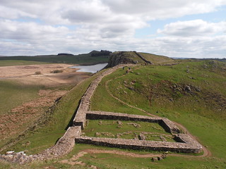
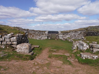
Milecastle 39 (Castle Nick)
SWC Walk 413 - Hadrian's Wall Path Core Section (Lanercost to Halton Chesters)
Apr-23 • thomasgrabow on Flickr
swcwalks swcwalk413 banner 53043066772
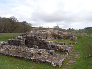
Willowford Bridge Abutment
SWC Walk 413 - Hadrian's Wall Path Core Section (Lanercost to Halton Chesters)
Apr-23 • thomasgrabow on Flickr
swcwalks swcwalk413 walkicon 53044036655
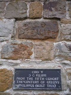
Centurial Stone at Willowford Farm (with plaque with English translation)
SWC Walk 413 - Hadrian's Wall Path Core Section (Lanercost to Halton Chesters)
Apr-23 • thomasgrabow on Flickr
swcwalks swcwalk413 walkicon 53043651506
Turret 41A (Caw Gap)
SWC Walk 413 - Hadrian's Wall Path Core Section (Lanercost to Halton Chesters)
Apr-23 • thomasgrabow on Flickr
swcwalks swcwalk413 walkicon 53043066057
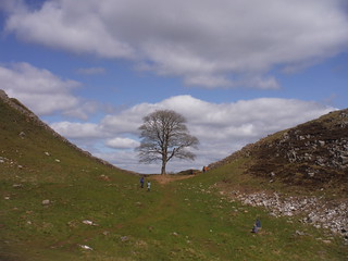
Sycamore Gap
SWC Walk 413 - Hadrian's Wall Path Core Section (Lanercost to Halton Chesters)
Apr-23 • thomasgrabow on Flickr
swcwalks swcwalk413 walkicon 53043829909
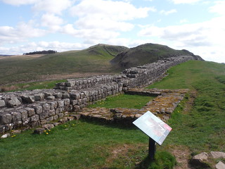
Milecastle 37 (the one with part of the northern arch still in place) on Housestead Crags
SWC Walk 413 - Hadrian's Wall Path Core Section (Lanercost to Halton Chesters)
Apr-23 • thomasgrabow on Flickr
swcwalks swcwalk413 walkicon 53043830129
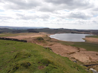
Sweeping Backview from Sewingshields Crags with Broomlee Lough
SWC Walk 413 - Hadrian's Wall Path Core Section (Lanercost to Halton Chesters)
Apr-23 • thomasgrabow on Flickr
swcwalks swcwalk413 walkicon 53044141773
| Length |
54.0 km (33.6 mi), with 961/865m ascent/descent. For using link routes from train or bus stations to create day walks, see below Walk Options and Example Daywalks. |
|---|---|
| Toughness | 10 out of 10, with 13 hours walking time. |
| Walk Notes |
The 135 km (84 miles) long Hadrian’s Wall Path (HWP) is usually walked either in stages, often with luggage transport and accommodation pre-booked, or on short walks from car parks nearby. But as long stretches of the HWP lead through flat country or large towns without notable amounts of Roman era remains, this can feel an unnecessarily long endeavour, as well as a bit samey after a while. This route thus covers just the core section of the HWP that contains most of the extant pieces of the wall and its assorted support structures (forts, milecastles, turrets, signal towers, vallum, military road), while also leading through a scenic landscape attractive to walkers with rolling hills and pastureland, imposing north facing crags, deep cut valleys and some upland moorland. The area covered stretches from Brampton, not far east of Carlisle, via the busy market towns of Haltwhistle and Hexham to another fine historic town: Corbridge, with the latter three all being in commuting distance from the Newcastle/Gateshead Conurbation. Link Routes from train or bus stations enable public transport based day walks, combining stages of the HWP with attractive routes to or from towns and villages with accommodation and/or cafés, pubs and restaurants. The HWP is very well marked and signed (and all sights have copious info panels), so that only the main characteristics of the individual HWP stretches are described. For detailed directions try these books: ‘Trekking the Hadrian’s Wall Path’ (Knife Edge) or ‘Walking Hadrian’s Wall Path’ (Cicerone). The Link Routes though are described in detail in both directions to enable total flexibility. |
| Maps |
OS Landranger: 86 (Haltwhistle & Brampton) & 87 (Hexham & Haltwhistle)
|
| Travel |
Haytongate/Lanercost Turnoff, map reference NY 553 645, is 422 km northwest of Charing Cross, 18 km northeast of Carlisle, 93m above sea level and in Cumbria. Down Hill, by Halton Chesters, map reference NZ 004 684, is 409 km north northwest of Charing Cross, 25 km west northwest of Newcastle-upon-Tyne, 189m above sea level and in Northumberland. For using link routes from train or bus stations to create day walks, see below Walk Options. Neither start nor finish of this linear route have nearby public transport options, but 8 link routes are described from 6 locations, either stations on the Tyne Valley Line (Newcastle – Carlisle), with frequent trains at all those stations, or from corresponding bus stops on the frequent Line 685 (Carlisle – Newcastle). Saturday Walkers’ Club: Daywalks from bases in the area are possible when using the link routes. |
| HWP Stages |
Haytongate/Lanercost Turnoff (for Brampton) to Tipalt Burn (for Greenhead Bypass): 12.2 km/7.6 mi, 170/132m ascent/descentPastures with some woods, mildly undulating apart from the crossings of Banks Burn and River Irthing. The section west of the River Irthing was originally constructed as a Turf Wall, 6m wide at its base, and between Milecastles 49 and 51 the Stone Wall later followed a line north of the Turf Wall. Sights: fine stretches of Vallum and Turf Wall, some signal towers and turret bases, the highest surviving piece of Wall (only short and partly rebuilt though); Birdoswald/Banna Fort (ticketed), Willowford Bridge = the stranded bridge (the river has changed course), some fine bits of Wall, in places with Broad Wall base topped with Narrow Wall; Milecastle 48 at Gilsland, the best-preserved of all. Tipalt Burn (for Greenhead Bypass) to Cawfield Quarry (for Haltwhistle): 6.6 km/4.1 mi, 157/112m ascent/descentSteady ascent out of Walltown Quarry onto the Walltown Crags, then gentle descent into the cut created by the Haltwhistle Burn. Sights: Thirlwall Castle ruins (12th century, mainly using stones from the Wall), Carvoran/Magnis Fort, Roman Army Museum, Great Chesters/Aesica Fort; long stretches of Wall, the Vallum is mostly well away from the Wall though. Cawfield Quarry (for Haltwhistle) to Housesteads (for Bardon Mill): 8.6 km/5.4 mi, 243/154mSteady ascent to the highest point on the HWP, at Winshield Crags, followed by undulating route along a steady line of crags, with dramatic views north across commons and moors, as well as to the south across pastures. Sights: the famous ‘Sycamore Gap’ with the ‘Robin Hood Tree’, Crag Lough, Housesteads/ Borcovicium Fort (interior ticketed but can be walked around); high presence of Roman structures due to the remoteness of the area and its inaccessibility for the ‘recycling’ of rocks in farms, roads, ecclesiastical and private buildings. Housesteads (for Bardon Mill) to B6318 near Walwick (for Hexham): 13.8 km/8.6 mi, 132/302m ascent/descentInitial ascent onto the very scenic Sewingshields Crags, followed by long and gentle descent into the North Tyne Valley. Sights: high presence of old structures initially (although the long section of ‘Clayton Wall’ between Housesteads and Steel Rigg has been rebuilt in the 1830s), then becoming rarer as HWP runs close to Vallum and Military Road along a broad ridge, but with the late highlight of Carrowburgh/Brocolitia Fort, Mithraeum and Well. Later still: Black Carts Turret and long stretch of Wall. B6318 near Walwick (for Hexham) to Planetrees (for Hexham): 4.5 km/2.8 mi, 129/62m ascent/descentMostly road pavement with some fast traffic including crossing the North Tyne on a road bridge. Sights: Chesters/Cilurnum Fort & Museum (ticketed); abutment of Chesters Roman Bridge over North Tyne (750m off route); two good, long pieces of Wall and Wall footings in fields, showing the change from Broad Wall to Narrow Wall, one also including Turret 26B (the Brunton Turret), the best-preserved one with a freestanding altar. Planetrees (for Hexham) to Down Hill, by Halton Chesters (for Corbridge): 8.3 km/5.2 mi, 125/99m ascent/descentHWP runs along or close to the (modern) Military Road along a broad ridge with views to the South into the Tyne Valley and to the North along the North Tyne Valley to the forests of the Borderlands and to the Cheviots. Sights: very good and long piece of Wall, showing evidence of the change from the 3.0 metre-wide Broad Wall to the 2.4 metre-wide Narrow Wall (to save time); at Port Gate, Dere Street, the main Roman Road to Scotland crossed HW (now the A68); route passes wooden cross and St. Oswald’s Church at Heavenfield, site of a 7th century battle (Christian Northumbria vs Pagan Welsh); good evidence of the Vallum, but Wall mostly buried under the B6318; some Wall platforms at Milecastle 24; Halton Chesters/Hunnum Fort is just grassy mounds. |
| Link Routes |
Brampton to Haytongate/Lanercost Turnoff7.7 km with 113/148m ascent/descent from Brampton Station or 1.5 km and 54m descent less from Brampton, Shoulder of Mutton or Sands Bus Stops. Quiet route up to Brampton Ridge (with a view of the ridge holding Hadrian's Wall) and down through the wooded Quarrybeck Gorge to Lanercost Old Bridge across the River Irthing and past Lanercost Priory up to Haytongate.Greenhead to Tipalt Burn1.0 km with negligible ascent/descent from Greenhead Bypass Bus Stop (Lines 685 and AD122). Flat along the Tipalt Burn to the meeting with the Paw Charney Burn tributary.Haltwhistle to Cawfield Quarry4.0 km with 83/21m ascent/descent from Haltwhistle Station or slightly less from Haltwhistle Market Place Bus Stop. Up out of the South Tyne Valley through the heart of the historic market town and up the Burn Gorge, full of remnants of a thick industrial past based on mining, brickworks and the power of the fast flowing water. Then across the open upland through the Roman Military Zone, with impressive traces of Stanegate Roman Road, Haltwhistle Burn Roman Fortlet, Roman Marching Camps and Cemeteries.Bardon Mill to Housesteads5.7 km with 261/84m ascent/descent from Bardon Mill Station via Thorngrafton Common or 6.9 km with 242/65m ascent descent via Vindolanda Roman Fort. Or slightly shorter from Bardon Mill Bowes Hotel Bus Stop. Out of Bardon Mill village along country lanes and up Thorngrafton's grassy common onto Barcombe Hill, with stunning views across an upland plateau to the undulating craggy landscape that is the core and most scenic part of Hadrian's Wall Path. An alternative route up the Chainley Burn gorge and past Vindolanda Roman Fort (which preceded Hadrian's Wall) avoids the hill ascent.Hexham to B6318 near Walwick9.1 km with 123/62m ascent/descent from Hexham Station or slightly longer from Hexham Bus Station. From the outskirts of Hexham along the River Tyne to the Watersmeet, the confluence of South and North Tyne, then up along a quiet country lane out of the Tyne Valley to the course of Hadrian's Wall.Hexham to Planetrees6.7 km with 208/80m ascent/descent from Hexham Station or slightly longer from Hexham Bus Station. From the outskirts of Hexham across the River Tyne and up to the lofty church of St. Peter Lee. Down and up to Acomb village and down and up to a quiet country lane with fine views into the North Tyne Valley and through the Crag House Estate to a fascinating stretch of Wall at Planetrees.Corbridge to Down Hill by Halton Chesters6.7 km with 188/33m ascent/descent from Corbridge Station or slightly shorter from Corbridge Angel Inn Bus Stop. Through the very pretty Corbridge with its many historic buildings out of the Tyne Valley and past historic Aydon Castle via a quiet country lane to Halton Church and Castle, both built from Wall Stone, then onto the line of the Wall itself. |
| Walk Options |
The whole route is easily doable as a two or three-day walk, with accommodation options near the wall listed in the books mentioned above.
Buses connecting parts of the route or the link routes with train stations or with Bus Line 685 are (as of 07/23):
|
| Example Daywalks |
Brampton Station to Greenhead, 19.4 km/12.1 mi, 285/285m ascent/descent, 4/10 rating;
|
| Eat and Drink |
On or close to the HWP: (details last updated 07/23)
On the Link Routes: (details last updated 07/23)
|
| Notes |
Hadrian’s Wall/Vallum Aelium, Stanegate, The Vallum
Hadrian’s Wall Path
A Pennine Journey
Whin Sill
It was formed when fresh magma intruded in spaces opened up by tectonic movements of existing crust layers and then – on cooling – crystallised and solidified. The Pennine Way
|
| Profile | |
|---|---|
| Help Us! |
After the walk, please leave a comment, it really helps. Thanks! You can also upload photos to the SWC Group on Flickr (upload your photos) and videos to Youtube. This walk's tags are: |
| By Car |
Start Lanercost, Cumbria, CA8 2HL Map Directions Finish Down Hill, Corbridge, NE45 5QA Map Directions |
| Amazon | |
| Help |
National Rail: 03457 48 49 50 • Traveline (bus times): 0871 200 22 33 (12p/min) • TFL (London) : 0343 222 1234 |
| Version |
Sep-23 Thomas G |
| Copyright | © Saturday Walkers Club. All Rights Reserved. No commercial use. No copying. No derivatives. Free with attribution for one time non-commercial use only. www.walkingclub.org.uk/site/license.shtml |


Walk Directions
Full directions for this walk are in a PDF file (link above) which you can print, or download on to a Kindle, tablet, or smartphone.
This is just the introduction. This walk's detailed directions are in a PDF available from wwww.walkingclub.org.uk