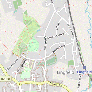
Dormans to Lingfield walk
Historic buildings, a Racecourse and a small Nature Reserve with a Community Orchard in the south-eastern corner of Surrey.
| Length |
Main Walk: 16¾ km (10.4 miles). Three hours 45 minutes walking time. For the whole excursion including trains, sights and meals, allow at least 8½ hours. Short Walk, omitting northern loop: 11¼ km (7.0 miles). Two hours 30 minutes walking time. Short Circular Walk, returning to Dormans: 15¼ km (9.5 miles). Three hours 30 minutes walking time. Extended Walk 1, with Lingfield ‘preamble’: 20 km (12.4 miles). Four hours 35 minutes walking time. Extended Walk 2, returning to Dormans: 20¾ km (12.9 miles). Four hours 45 minutes walking time. Long Walk, with both extensions: 24 km (14.9 miles). Five hours 35 minutes walking time. |
|---|---|
| OS Maps |
Explorer 146 & (for the Dormans extension) 147. Dormans station, map reference TQ397415, is in Surrey, 3 km N of East Grinstead. |
| Toughness |
2 out of 10 (3 with either extension, 4 with both). |
| Features |
This walk in the south-eastern corner of Surrey essentially consists of two near-circular walks linked together. The first loop is around the fringes of a historically interesting housing development to the south of Dormans station, with the outward path showing the cuttings, embankments and viaducts needed to build a railway through this undulating countryside. The second loop goes through a Local Nature Reserve and farmland in the low-lying countryside to the north of Lingfield. The arrival of a new railway line invariably leads to speculative housing development – sometimes by the railway company itself, as related in John Betjeman's celebrated TV documentary Metroland. The Oxted–East Grinstead line opened in 1884 and a few years later the Bellaggio Estate Company bought 218 acres of farmland and woodland to the north of East Grinstead. It planned to develop a “New Bungalow Town and Club” but only completed about twenty sizeable residences before it failed. Many new houses have since been built but the Green Belt has protected the rest of Dormans Park, leaving properties scattered around plots in mature woodland like dachas in a Russian forest. After a circuit of the estate and a brisk gallop up the long straight of Lingfield Park Racecourse, a woodland bridleway brings you into the large village of Lingfield. The suggested lunchtime pub is on the edge of the Old Town conservation area, which contains many well-preserved 16th–18thC buildings clustered around the grand parish church. Parts of the afternoon route overlap both the Lingfield & Crowhurst Age to Age Walk and (in reverse) the end of the Oxted to Lingfield walk (#135). The route out of the village goes through Lingfield Nature Reserve and continues across a flat plain, the venue for the Edenbridge and Oxted Agricultural Show on the August Bank Holiday weekend. It loops back across farmland to the Nature Reserve, this time going through its Community Orchard. There are pubs or a coffee shop for refreshment before an optional short loop through a water meadow to the station. This walk is probably best avoided when the Agricultural Show is on. Although the public footpaths here (and across the racecourse on race days) should remain open, the village and trains will be busier than usual. |
| Walk Options |
The afternoon leg has two crossover points near the start so you can easily shorten the walk by cutting out the 5½ km loop to the north of Lingfield (or even head directly back to the station). By itself this would make for a rather unbalanced Short Walk, but worth considering if you had seen from the train that these low-lying fields were flooded. A more satisfying option would be to switch to the post-walk extension described below (which is on higher ground) for a Short Circular Walk back to Dormans. Directions have been provided for optional extensions at both ends of the walk, making circular walks from both Lingfield and Dormans. Brisk walkers doing the 3¼ km pre-walk extension (or ‘preamble’) from Lingfield will reach Dormans not long after the next train arrives, so should be able to catch up the main group if they set off half an hour earlier. A slightly longer and quite different route is provided for the post-walk extension to Dormans, with further refreshments available at an out-of-the-way village pub on the way to this station. |
| Transport |
Lingfield and Dormans are adjacent stations on the East Grinstead line, with a half-hourly off-peak service from Victoria. The journey time is around 50-55 minutes. Unless you are doing a Circular Walk from Lingfield, buy a return to Dormans. If you want to abandon the walk in mid-morning there is an infrequent bus service along Felcourt Road at the southern tip of Dormans Park (Mon–Sat), but it will usually be quicker to head for one of the stations. If driving, there is limited roadside parking at Dormans station but no car park. It would be simpler to park at Lingfield and take the train to Dormans (or do the preamble). Lingfield station car park costs around £7 Mon–Sat, £2.50 Sun & BH (2023). |
| Suggested Train |
Take the train nearest to 09:50 from Victoria to Dormans, or half an hour earlier (to Lingfield) if doing the pre-walk extension. |
| Train Times |
|
| Timetables |
|
| River Levels |
|
| Lunch |
In Lingfield the walk route goes past The Star (01342-832364) after 8 km. It is just outside the picturesque Old Town, has a large garden and serves good food all day. For an alternative you would have to detour to one of the Tea places listed below. |
| Tea |
The suggested tea place in Lingfield is Costa Coffee (01342-837843; open to 6pm Mon–Sat, 5pm Sun) on East Grinstead Road, near the village pond. A nearby alternative but with earlier closing times is the Red Rum Caffé (01342-459752; open to 4pm Mon–Sat, 3pm Sun & BH), while stronger fare is available at the Greyhound pub (01342-832147). You could also make another visit to The Star, the closest place to the station. Note that the station is at least 1 km from the centre of the village; 2 km if you take the suggested route via the water meadow. The post-walk extension goes past The Old House at Home (01342-836828) in the village of Dormansland, 1 km before Dormans station. A detour would take you to an alternative pub on Dormans High Street, the Royal Oak (01342-836611). |
| Profile | |
|---|---|
| Help Us! |
After the walk, please leave a comment, it really helps. Thanks! You can also upload photos to the SWC Group on Flickr (upload your photos) and videos to Youtube. This walk's tags are: |
| By Train |
Out (not a train station) Back (not a train station) |
| By Car |
Start RH7 6NL Map Directions Return to the start: Finish RH7 6EF Map Directions Travel to the start: |
| Amazon | |
| Help |
National Rail: 03457 48 49 50 • Traveline (bus times): 0871 200 22 33 (12p/min) • TFL (London) : 0343 222 1234 |
| Version |
Aug-23 Sean |
| Copyright | © Saturday Walkers Club. All Rights Reserved. No commercial use. No copying. No derivatives. Free with attribution for one time non-commercial use only. www.walkingclub.org.uk/site/license.shtml |

Walk Directions
Click the heading below to show/hide the walk route for the selected option(s).


 Walk Map
©
Walk Options
Click on any option to show only the sections making up that route, or the heading above to show all sections.
- Main Walk (16¾ km)
Walk Directions
Click on any section heading to switch between detailed directions and an outline, or the heading above to switch all sections.
Unless you are doing the Lingfield ‘preamble’, start at [?] in §A.
- Lingfield Station to Dormans Station (3¼ km)
- Leave the station at the southern end of Platform 2 and take the footpath heading east along the edge of water meadows, crossing two streams. Turn right onto a footpath leading to St Piers Lane and turn right onto this road, passing Lingfield College. Turn right again onto the B2028, going under the railway bridge. Turn left onto a tree-lined bridleway (Mill Lane) heading south for 1¾ km. Shortly after crossing the railway again turn right onto a footpath leading to Dormans station.
-
Arriving from London for the ‘preamble’, do not cross the footbridge to the main station exit but walk down to the East Grinstead end of Platform 2. This looks like a dead end but it leads to a short fenced path alongside the tracks. At the end go through a gate on the left into a water meadow.
The route along Platform 2 is an official footpath diversion, as the right of way across the tracks at the southern end of the station has been the subject of a ‘temporary’ closure order since 2011 when two girls were almost hit by a train.
- Follow a grassy path along the right-hand side of the meadow, heading E. Cross Eden Brook? on a substantial footbridge and keep ahead on a fenced path alongside another part of the meadow.
- At the end cross a second stream on a footbridge, bear right and go through a metal kissing gate onto a broad tree-lined track. Follow this potentially muddy path gently uphill for 150m, passing an inconspicuous stone tablet? on the right-hand side halfway along.
- Shortly after the path bends left, fork right at a Y-junction. Ignore a gate leading into a school playing field and go along the edge of a large field, with a hedge on your right.
- At the end of the hedge bear slightly left across a projecting part of the field. Go through a metal kissing gate in the hedge ahead and turn right onto a minor road (St Piers Lane), soon passing the buildings of Lingfield College? Senior School.
- At the T-junction with the B2028 (Racecourse Road) turn right and go along the main road for 200m, passing Stanhope Cottages and going under the railway bridge. Cross the road carefully at some point. Immediately before the entrance to the Marriott Hotel turn left onto a signposted bridleway, heading S.
-
After passing Mill Lane Cottages the bridleway continues as a broad tree-lined path, with Lingfield Park Golf Course on both sides. Follow it through Mill Wood for 750m, ignoring crossing paths used by golfers. After going alongside a stream in a gully on the right turn left at a four-way path junction to stay on the bridleway, away from a footpath crossing the stream on a brick bridge.
After the loop around Dormans Park the walk route comes back across this bridge and retraces the stretch along the bridleway to the B2028.
- The bridleway soon swings right and climbs steadily. For most of the way there are trees shielding you from the golf course, but you need to take care where the track crosses a fairway (with golfers playing from ahead on the left). In 600m the bridleway crosses the railway on a brick bridge, with Dormans station visible off to the right. Go past a cottage and keep right to stay on the bridleway.
- In 250m turn right at a path crossing by the entrance to “Nobles Green”, with another stone tablet by the bench on the right. Follow the tarmac path down through a copse and then across a semi-open area to reach Dormans Station Road. Turn right to go past the small station building and cross the tracks on the footbridge alongside the road bridge.
- Dormans Station to Felcourt Road (2½ km)
-
- If starting the walk here, turn right onto the footbridge alongside the road bridge.
-
Starting from Dormans Station
- If arriving from London, go up steps at the East Grinstead end of the platform and turn right onto the footbridge alongside the road bridge.
- At the top of the ramp to Platform 1 cross Dormans Station Road carefully and take the signposted footpath opposite, down a flight of steps. For much of this section you will be heading S on a path parallel to the railway tracks (sometimes high above them, sometimes below). In 900m go straight ahead across a lane (The Approach) leading into the Dormans Park estate, with the railway passing under the bridge on your left.
- The footpath now descends steadily for 250m so that when you cross the next lane (Lake View Road), you are well below the level of the railway. Continue on the enclosed path opposite, with a high metal fence on the left rather spoiling the view of Cook's Pond Viaduct?. On the far side go between vehicle barriers and follow the path up to a T-junction with a bridleway.
- Turn right onto the bridleway, heading W and soon ignoring a footpath off to the left. In 400m the bridleway crosses a stream and continues with gardens behind a high green fence on the right. At the end of the fence keep ahead at a major path crossing, staying on the bridleway. In 250m there are houses and gardens on the left and the path comes to a T-junction with an unsurfaced lane in front of a bungalow “The Cottage”.
- Turn left and follow the lane for 250m, curving gently right and passing a few more properties. The next turning is easy to miss. Just before the last house, and about 40m before the lane comes out onto Felcourt Road, turn sharp right onto a narrow footpath.
- Felcourt Road to Lingfield Park Golf Course (2½ km)
- Follow the footpath northwards through woodland and the Dormans Park estate for 1¼ km. At Tanglewood turn left onto a footpath going across a wooded valley and up between fields. Turn right at a path T-junction and follow this footpath out to Blackberry Road. Turn right onto Blackberry Road and fork left onto a short link road. Cross over Blackberry Lane onto Lingfield Park Golf Course.
- Follow the rather gloomy path between garden fences and tall trees, later with glimpses of Charters Village? on the left. The path goes gently downhill and passes some ponds in the wood on the right. Keep ahead across a stream onto a broad track, climbing gently. In 100m you pass Chestnut Cottage and The Clock House? on the left, now on an estate road.
-
Ignore Furzefield? Chase on the right and keep ahead on Swissland? Hill, still climbing gently. In the next 250m ignore two more estate roads on the right and continue for a further 400m. The next turning is easy to miss. Just before the driveway to “Tanglewood” turn left onto a signposted footpath between hedges.
The right of way used to leave the road on the other side of the driveway but has been rerouted to this more sensible location.
- After passing the house there is a slightly awkward descent over tangled tree roots. At the bottom the footpath crosses a stream on a substantial footbridge with handrails and continues along an unusual corduroy road?, then on an attractive tree-lined path climbing gently between fields. At the top turn right onto a broad grassy path between fences.
-
At the end go through a side gate to continue along a tarmac driveway. In 200m it swerves left and right towards a house, with a choice of paths ahead. The waymarkers currently direct you through a metal kissing gate and along the top of a grassy bank in full view of the house, but a new path going straight ahead at the first bend makes a less intrusive alternative route.
As at Tanglewood the owner might be attempting to reroute the right of way, although at the time of writing there was no notice inviting walkers to take this new path.
- After passing the house the new path turns left to rejoin the right of way, alongside a wooden fence. Go out through a gate in this fence onto Blackberry Road and turn right. The road soon comes to a Y-junction where you fork left onto a short link road leading to Blackberry Lane. Cross this road carefully (it has faster traffic than you might expect) and go through a gap in the trees opposite onto Lingfield Park Golf Course.
- Lingfield Park Golf Course to Mill Lane (1 km)
- Follow the right of way across the golf course, initially to the right close to the road and then zig-zagging left and right alongside a stream to the long straight of Lingfield Park Racecourse. Cross the racetrack at the designated point and turn left to head north alongside it for 175m, then veer right to meet a bridleway (Mill Lane).
- Do not cross the fairway ahead but immediately turn right and take a path into and through the edge of a copse. The path stays close to the road for a while, then swings left and emerges back onto the fairway. The right of way through the golf course now closely follows the course of a stream on your right.
- Go straight across the fairway (with golfers playing down the slope from the left), ignoring a footbridge across the stream. After going through a belt of trees turn right to stay close to the stream, heading E. Make your way across the grass towards a copse, where the right of way continues on a short path bearing left through the trees.
- At the end keep right to go alongside a fairway. Go through a gap in the line of trees ahead and follow a grassy track round to the left, now heading N beside the long straight of Lingfield Park Racecourse?, with the Grandstand 1 km ahead.
- At the ⑤ furlong marker turn right to cross the racetrack at the designated crossing point, then turn left to continue between the racetrack and a golf fairway. The right of way does not extend to the finishing post, so before reaching the ④ furlong marker turn right at a footpath signpost by some trees.
- Follow a slightly raised path alongside the fairway out to a track and turn right onto it, away from some buildings. The track crosses a stream on a brick bridge and comes to a four-way junction.
- Mill Lane to The Star (2 km)
- Turn left onto Mill Lane and follow the bridleway through Mill Wood. At the end turn left onto the B2028 (Racecourse Road). Opposite the racecourse entrance take a tarmac path across an open space to Lingfield station. Go out along its approach road and continue on the footpath heading west to The Star inn on Church Road.
- At the junction turn left onto a bridleway (shown as Mill Lane on the OS map), with the stream down to your left. Follow this broad path as it winds its way northwards through Mill Wood for 750m, ignoring a left fork to the 18th tee after 100m and other crossing paths used by golfers.
- The bridleway comes out by Mill Lane Cottages and continues along a narrow lane to reach the B2028 (Racecourse Road). Turn left and go along the main road for 250m, passing Lingfield College? Prep School on the right. If you have not already done so, cross the road at the pedestrian lights by the visitor entrance to the racecourse and take the broad tarmac path opposite.
- The path curves left past a few houses and then heads N across a large open space, dotted with trees. In the far corner you come to a path junction by a way onto Platform 1 at Lingfield station. Unless you want to abandon the walk, keep ahead on the narrow path alongside the platform, separated from it by high metal railings.
- At the end turn left into the station forecourt and go out along its approach road. Cross Station Road carefully and take the tarmac path opposite, heading W alongside the high wall of New Place?, then between fields.
-
In 400m this tree-lined path comes out onto Church Road with the suggested lunch place on the left, The Star inn.
- For an alternative lunch place you would have to make your way to the High Street: there are a few cafés, restaurants and another pub clustered around the village pond.
- The Star to Beacon Field (½ km)
- Take the short street through the Old Town to Lingfield church. Go through the churchyard and leave at its northern exit. Cross over Vicarage Road and continue on an alleyway leading into a Recreation Ground. Keep ahead across Jenner's Field and along the right-hand edge of Beacon Field to a path crossing.
- From the pub cross Church Road and take the short street of fine old houses on the right, passing an information panel The Church · Old Town about the Lingfield Conservation Area on the right-hand wall. Enter the churchyard and fork left onto the path going around the surprisingly grand parish church of Ss Peter and Paul?, which is well worth visiting; its entrance is through the west door in the tower.
- Take the path leading to an exit on the northern side of the churchyard (ie. turn right if coming out of the church). Go down a short flight of steps onto a path past the attractive Guest House (now a library). Cross Vicarage Road and go up the steps opposite to continue along an alleyway.
- At the end go through a wooden kissing gate into the corner of Jenner's Field, a large recreation ground which is one of the constituents of Lingfield Nature Reserve?. Go diagonally across the field towards the hedge on the far side, aiming for a point halfway between the skateboard ramp and a wide gap in the hedge off to the right.
- At this point cross the perimeter path and go through a narrow gap in the tree boundary. Keep right to emerge into Beacon Field; the fire beacon is off to the left, but initially hidden behind a clump of trees. Continue along the right-hand field edge, soon coming to a path crossing.
- Beacon Field to Moat Farm (2 km)
- Keep ahead through Beacon Field and Coldharbour Copse to leave the reserve at its northernmost point. Follow a driveway out to Lingfield Common Road. Cross the road and take the footpath just off to the left. After skirting around Sugham Farm turn right onto a footpath heading north. Follow it across Ray Brook and through several large fields used for the Edenbridge and Oxted Show. Turn right onto a driveway and follow it round to the left past the wide moat surrounding Moat Farm.
- Go straight ahead at the path crossing. In the field corner keep ahead on a path through Coldharbour Copse, joining the route of Walk #135 (in reverse). Continue across a patch of grassland, passing an old house “Coldharbour” behind the hedge on the left.
- Leave the Nature Reserve through a new wooden kissing gate and go out onto a driveway. Follow it round a bend to the left and keep right where another drive merges from the left. This long straight tree-lined driveway ends at a T-junction with Lingfield Common Road.
- Turn left briefly onto the road, then in 25m turn right onto a signposted footpath. Go past a rusty metal fieldgate onto a long straight green lane. At the far end go through a metal kissing gate and follow the lane round to the left. With a pond ahead, bear right to follow the right of way as it skirts around Sugham Farm, mostly on narrow paths but with a short interlude on a farm track.
- The final stretch is a narrow enclosed path alongside high metal railings. The path swings round to the left and comes to a three-way footpath junction where you turn right, heading N. At the end of this short fenced path cross Ray Brook? on a concrete bridge and squeeze past an old metal gate into a field.
- Keep ahead on a faint grassy path towards the far corner (not a more obvious exit away to the left). Before reaching the corner veer right and left through a wide gap in the hedge to maintain direction along the left-hand edge of the next field. In 100m, after the hedge has curved slightly to the right, go over a stile in the hedge into another large field.
- Follow a faint grassy path across it, heading NW and aiming for the far end of the long hedge away to your left. In this corner bear left (going over a stile if necessary) to continue along a broad grassy strip. In 200m, where it turns slightly left, go over a stile in the hedge on the right and turn right onto a driveway. Follow it round to the left and across a stream on a brick bridge, with the aptly-named Moat Farm? across the water on the left.
- Moat Farm to Beacon Field (3½ km)
- After passing the moat take the long straight footpath heading east to Crowhurst Road. Cross the road and continue on Bowerland Lane, just off to the right. Go all the way along this lane and turn right onto the B2028 (Haxted Road). After crossing Ray Brook take the footpath on the left past Rushford Farm. Cross the railway at Rushford Crossing and go straight across Station Road onto Saxbys Lane. In 200m turn right onto a short footpath leading back into Lingfield Nature Reserve. Turn left onto its perimeter path, passing the Millennium Ponds. Where the path swings left keep ahead into Beacon Field.
- At the end of the moat ignore the entrances to several properties ahead and turn right onto a long straight green lane heading E, signposted as a footpath. In 300m ignore a stile on the left (leaving the Walk #135 route). The path later goes through a small wooded area and eventually comes out onto Crowhurst Road.
- Cross this road carefully onto a small green with an interesting village sign? and turn right. At the end of the green turn left into Bowerland Lane and go all the way along this quiet lane, passing under the Oxted–East Grinstead line after 750m. At the end it swings right and comes to a T-junction with the B2028 (Haxted Road).
- Turn right onto this fairly busy road. You need to take great care for the next 150m as there is only a narrow grass verge and traffic is quite fast. On the bridge over Ray Brook cross the road carefully and then turn left into the driveway to Rushford Farm House, signposted as a footpath.
- In 60m go over a stile on the left and continue in much the same direction across a field, aiming to skirt the garden of the house ahead. Join a broad grassy path heading SW along the right-hand edge of several fields, passing the house's garden, a bungalow and farm sheds. Along the way you go through a pair of metal fieldgates and gradually approach the railway line on a low embankment.
- In the last field corner go through a gap with a metal fieldgate and bear left to continue alongside the embankment. In 100m go up a small slope and turn right to cross the tracks carefully, coming out by some new houses on the outskirts of Lingfield. Follow the short street ahead (slightly to the left) out to a T-junction with the main road, where Crowhurst Road on the right becomes Station Road.
- Cross Station Road carefully to continue on the residential street opposite (Saxbys Lane). In 200m you reach Lingfield's small Fire Station and turn right into its driveway (which is also a public footpath, though not signposted when last checked), going past the left-hand side of the building. You pass a scout hut off to the left and go through a wooden kissing gate to re-enter Lingfield Nature Reserve.
- Turn left onto its perimeter path, soon passing an information panel about the wildlife in the Millennium Ponds (you could detour over a stile to explore this small area of ponds and wetland, but there is no other way out). Continue along the perimeter path for a further 100m. Where it swings left bear right onto a grassy path and go through a gap in the hedge ahead into Beacon Field, crossing over your outward route.
- Beacon Field to Lingfield Church (1¼ km)
-
 Keep ahead across Beacon Field and continue through the Wildflower Meadow and Community Orchard. Follow the path round to the left to leave the reserve at its southernmost point. Turn right and go along Vicarage Road to the pond in the centre of the village. Turn left to go past it into the High Street, with a choice of refreshment places. Go back to the churchyard via Old School Place.
-
Follow the grassy path across Beacon Field, passing to the right of a clump of trees in the middle and then to the left of the fire beacon. Keep ahead through a wide gap in the tree boundary onto a path through a small Wildflower Meadow.
-
The path leads into a Community Orchard?, where the simplest continuation is to stay on the main path along its left-hand side.
- You might like to wander around the orchard before continuing the walk. On the right of the main path, by some large chestnut trees, there is a small information panel identifying the different fruit trees.
- The perimeter path passes some small gardens off to the left and leads into a track. Follow this out of the reserve to a residential street at a bend. Turn right and go along Vicarage Road for 300m to its T-junction with the B2028 (Plaistow Street).
- Unless you want to visit the Greyhound pub (just off to the right) turn left to come to the 400-year old Lingfield Oak and the Old Cage? beside the village pond.
- The suggested tea place is a Costa coffee shop on the left-hand side of East Grinstead Road (heading S from the roundabout beside the pond). The route continues around the pond to head E along the High Street, where the Red Rum Caffé is on the right.
- At the end of the parade of shops and restaurants turn left off the High Street into Old School Place. Where this turns left after 50m, keep ahead on an alleyway which leads into the churchyard, giving you a second chance to visit the church of Ss Peter and Paul?.
- Lingfield Church to Lingfield Station (1½ • ½ km)
-
Leave the main churchyard on its eastern side and take the path through the lower churchyard to Bakers Lane. Turn right and go along it to Station Road. Cross over and take a footpath just off to the left across the railway. Go along a farm track
and turn right in front of Eden Brook onto a permissive path through a water meadow. Leave the meadow in the far right-hand corner, coming out directly onto Platform 2 of Lingfield station; cross the footbridge for trains to London.
- Alternatively, leave the churchyard through the Old Town and take the footpath from Church Road directly to the station.
-
Main route (1½ km)
- If you have been visiting the church turn sharp left out of the west door onto the path along its south side, heading E. Follow the path round to the left and then almost immediately turn right onto a short path sloping down to Church Road. Go straight across this road into the much larger lower churchyard. Follow a path all the way through it to the bottom left-hand corner and out onto Bakers Lane.
-
Turn right and go along this residential street for 250m, with the footway on the right-hand side straightening out a slight bend. At the end cross Station Road carefully and continue on a short driveway just off to the left, up to a level crossing over the railway line with a footpath waymarker.
The crossing used to allow vehicle access to Park Farm but is now for pedestrians only.
- Cross the railway and continue on an unsurfaced farm track between hedges, ignoring a metal fieldgate into the water meadow on the right after 100m. A little further on, just before the track crosses Eden Brook?, there is a wooden kissing gate into this meadow with a “Permissive footpath only” sign.
- Turn right through this gate onto a grassy path across the meadow, never far from the meandering brook on your left. Shortly before reaching a footbridge across it (where you can see the station away to the right) veer right onto a grassy path leading to the right-hand corner of the meadow.
-
Go out through a wooden gate onto a short fenced path leading directly onto the end of Platform 2. Unless trains are terminating here because of engineering works further down the line, you will have to walk along the platform and cross the footbridge to Platform 1 for trains to London.
In the past you would have been able to go directly onto Platform 1, but …
-
Direct route (½ km)
- On the south side of the church take the path sloping down to the south-eastern corner of the churchyard. Go back down the short street of historic houses to Church Road, where The Star is the last refreshment place before the station.
- To complete the walk take the public footpath on the north side of the pub, a tree-lined tarmac path between fields and then past the high wall of New Place?. At the end cross Station Road carefully to reach the station. If the ticket office is closed, the entrance to Platform 1 (for trains to London) is at the left-hand end of the building.
- Lingfield Church to Gratwick's Wood (2¼ km)
-
…
which crosses Eden Brook and turn right at a footpath T-junction at Park Farm. At Mulberry Cottage turn left onto a permissive path around two sides of a large field. In the opposite corner turn left onto a public footpath leading to Gratwick's Wood.
- If the bridge over Eden Brook is fenced off, you can detour through the water meadow on the right and turn left onto the same public footpath.
- …
- …
- …
-
Main route
- Continue along the track for 200m, passing Park House on the right. At a T-junction in front of a new building at Park Farm turn right onto a track leading to Mulberry Cottage, which is also a public footpath.
- In 175m, by the entrance to the cottage, turn left off the public footpath. Follow a permissive path up the left-hand edge of a large field, with views across the Eden valley to the Greensand Hills.
- In the top corner follow this chalky path round to the right, ignoring a path ahead towards a wood. Continue along the tree-lined field edge for a further 500m to a path crossing and turn left onto a public footpath.
-
Alternative route
- … At the far end turn left to cross the brook …
- …
- Shortly after the path bends left, veer left and right to continue in the same direction, ignoring footpaths off to both sides. In 100m keep ahead at a path crossing, where the main route joins from the tree-lined path on the left.
- Follow the footpath along the right-hand edge of a large farm field for 300m. Along the way ignore a side path into the tree boundary, but when you reach the far corner veer right into the trees as indicated by a footpath waymarker. Go through a wooden gate into Gratwick's Wood and turn left.
- Gratwick's Wood to Dormansland (2¼ km)
- Follow the footpath through the wood, then across a couple of small fields to St Piers Lane. Turn right and go along the lane for 250m, passing the school buildings of “Young Epilepsy”. Where the lane bends right keep ahead on a footpath heading south past Carewell Wood to the B2028. Turn right briefly onto the main road, then take a footpath on the left between houses to Dormans Road. Continue on West Street opposite to reach The Old House at Home pub in 500m.
- Follow the public footpath all the way through this small wood, heading roughly E; there are occasional “Private Woodland” notices on trees to keep you on the right of way. Along the way the path passes a number of structures used by students at the nearby school. On the far side leave the wood through a gate.
- Go over a stile and follow a grassy path across two small fields, crossing a tree-lined stream between them on a footbridge. Go over another stile to come out onto a narrow country lane (St Piers Lane). Ignore the continuation of the footpath just off to the left and turn right onto the lane, soon going past a cluster of buildings for Young Epilepsy?.
- Where the lane bends right by a large pond, keep ahead on a signposted footpath (not the one to the left). Go across a patch of grass beside a low hedge into a small parking area to find the continuation of the right of way, a narrow path to the left of some bins. Follow this along the edge of a wooded area, passing more school buildings on the right.
- Go over a stile and keep left, staying near a fence on the left. Go over another stile and continue alongside Carewell Wood on the left. At the end go through a metal fieldgate and bear right to go up the right-hand edge of a large field.
- In the top corner go out through a wooden kissing gate onto the B2028 (Racecourse Road). Turn right briefly onto this main road, taking great care as there is no pavement. Cross over carefully and in 40m turn left onto a signposted footpath, a narrow alleyway between garden fences. In 150m it turns half-right and comes out onto another road (Dormans Road).
- Cross this road carefully to continue on a footway alongside West Street opposite. In 100m follow the lane sharply round to the left; you could cross over to another footway behind the trees on its right-hand side but eventually you will have to walk along the lane. In 400m you come to a possible refreshment stop on the left, The Old House at Home? pub.
- Dormansland to Dormans Station (1 • 1½ km)
- Unless you want to detour across the recreation ground to the Royal Oak pub on Dormans High Street, keep ahead along The Platt, View Terrace and then a footpath to Dormans station.
-
Main route
- Continue along West Street and in 100m keep right at a fork, into The Platt. Go past a row of houses (View Terrace) to a T-junction and turn right.
-
Detour via the Royal Oak (+½ km)
- Continue along West Street for 40m and turn left onto a short track leading into the bottom of a large recreation ground. Veer right onto a tarmac path going all the way through it. Near the top fork left to come out onto Dormans High Street. The Royal Oak is 75m off to the left, opposite the Village Stores.
- Return along the High Street and go past the recreation ground. After passing the churchyard turn right into The Platt. In 100m fork left at a Y-junction, then in a further 125m keep ahead where the main route joins from View Terrace on the right.
- The lane bends left and passes a few more houses. Go between the entrance to the last two houses onto an enclosed tarmac path through a dip, ignoring another footpath off to the left at the bottom. Follow the path up a slope and across a more open area, then alongside the grounds of a large house.
- Keep ahead at a path crossing by the entrance to “Nobles Green”, with an inconspicuous stone tablet? … Go down the ramp to Platform 1 for trains to London.
- Eden Brook and Ray Brook are major tributaries of the River Eden. They meet at Waterside and flow into the main river near Haxted.
- Several stone tablets have been placed along the Greenwich Meridian, inscribed 2000 A.D. Erected by Lingfield & Dormansland Parish Council to mark the 0° Meridian Line.
- Lingfield College is a co-educational independent day school, spread across two sites: a Prep School and Senior School. It was was originally a Catholic girls school, founded by the School Sisters of Notre Dame in 1940.
- Cook's Pond Viaduct carries the Oxted–East Grinstead line across Wilderness Lake (which had to be drained while the brick piers supporting the latticed girders were being built).
- Charters Village is a modern development of retirement homes, completed in 2016.
- The Clock House was built in the late-19thC as a stable block, with accommodation for the stablehands on the first floor. The archway into the stable yard was filled in when the premises were converted into the present house.
- Swissland and Furzefield were the names of woods bought by the Dormans Park developers.
- This corduroy road (of logs placed across the direction of travel) was built by volunteers from the East Surrey Ramblers in partnership with Surrey County Council, no doubt improving a particularly muddy footpath.
- Lingfield Park Racecourse was opened in 1890. It stages flat and jumps racing all year round, on turf in summer and an all-weather track in winter.
- New Place was built in 1617 around the core of a medieval hall house. It is said to be the only surviving Jacobean stone mansion in Surrey. Much of the ashlar came from a monastery demolished in the Reformation.
- Ss Peter & Paul, Lingfield mostly dates from the 14thC, although there are traces of a much earlier Saxon church. It contains a fine collection of monuments and brasses to the Cobham family.
- The Lingfield Wildlife Area was established by local volunteers in 1994, transforming some unused fields to the north of the village. It has since been extended into Lingfield Nature Reserve, a varied set of habitats including wildlife ponds, a wildflower meadow, a community orchard and several small gardens.
- The house at Moat Farm was built in about 1800, replacing an earlier building. Many of the large houses in this area were moated and the body of water which remains gives some idea of its size.
- The Crowhurst village sign includes flags for both England and Estonia, the latter in tribute to the late Leo Luksepp, a “dedicated English patriot”. He settled in Crowhurst after World War Ⅱ and started several events to foster community spirit which continue to this day.
- The Community Orchard has been planted with several unusual fruit trees – medlar, quince and mulberry – as well as apples, pears, plums, cherries and various nut trees. It is not managed commercially and visitors are invited to take fruit for personal consumption.
- The Old Cage was built in 1773 to confine local miscreants. The last inmate was a poacher in 1882.
- Under the name Young Epilepsy St Piers School and College provide specialist education to young people with epilepsy, autism and associated conditions.
- There are around 25 pubs in England called The Old House at Home, all probably named after a sentimental 19thC ballad by Thomas Bayly. The song is about yearning for a childhood home, illustrated on the inn sign here by a soldier returning home.
You might come across some notices about “not deviating from the statutory route” across the golf course and racecourse, which would be easier to comply with if the public footpaths were clearly waymarked.
If you are doing either of the Short Walks and want to skip the 1½ km loop through the Nature Reserve and village, you can go to §I to finish at Lingfield or §J for Dormans.
If you are doing either of the Short Walks (omitting the northern loop), turn left at this path crossing and go to §H.
If you are doing the Extended Walk to Dormans, go to §J.
The suggested route to the station includes an attractive loop around the water meadow on the other side of the railway. If you are in a hurry you can take the direct route in [?], retracing your outward route past The Star.
In 2023 the bridge across this brook was fenced off as it was deemed unsafe. If this is still the case, take the alternative route in [?].
If you want to visit the Village Stores or try an alternative pub, follow the directions in [?].
Walk Notes
» Last updated: August 29, 2023
Return to Top | Walk Map | Walk Options | Walk Directions.