Tilbury to East Tilbury via the 2 Forts Way walk
The 2 Forts Way along the Thames Estuary coast path, passing Tilbury and Coalhouse Artillery Forts

The Thames at Tilbury
essex coast thurrock thames coastwalk164 swcwalks swcwalk357 36169955602
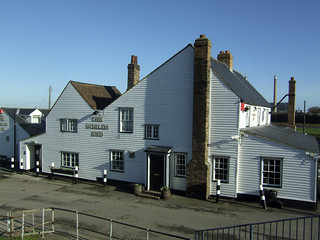
The Worlds End Pub at Tilbury
essex coast thurrock thames coastwalk164 swcwalks swcwalk357 35529979983

The Thames at Tilbury
essex coast thurrock thames coastwalk164 swcwalks swcwalk357 36338571225
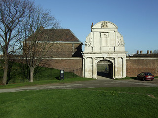
Tilbury Fort
essex coast thurrock thames coastwalk164 swcwalks swcwalk357 35502801944

Tilbury Fort
essex coast thurrock thames coastwalk164 swcwalks swcwalk357 35502800924

Tilbury Fort
essex coast thurrock thames coastwalk164 swcwalks swcwalk357 35502799204

Tilbury Fort
essex coast thurrock thames coastwalk164 swcwalks swcwalk357 35502798624
| Length | 8.1 miles (13 km), no ascent. |
|---|---|
| Toughness | 2/10 The path is unpaved in places, and there's broken glass (from the river) in places - you'll need walking shoes. |
| Map | OS Explorer 163 - Gravesend and Rochester |
| Walk Notes |
This walk is along the north bank of the Thames Estuary along a pretty section of coast (after the start) passes Tilbury Fort (English Heritage) and Coalhouse Fort (currently closed), and heads towards the site of a new coastal park on a former landfill site, before it heads inland to East Tilbury. This section of the England Coast Path is promoted as the Two Forts Way, as is passes 2 historic forts. The start of the walk, about 1.5km, from Tilbury Town station south to the "Thames Cruise Terminal" on the river along a walk/cycle path is currently a bit grim. There is no alternative (see below), although it will be improved when a new port opens as traffic will be diverted. Don't worry, the rest of the walk more than makes up for it. The main part of the walk follows the peaceful and pretty riverside path passing 2 former coast defence artillery forts, each with its own pub. The second, Coalhouse Fort, has a cafe and public toilets. Just inland is a pretty church The walk then continues along a peaceful part of the estuary before the coast path ahead is blocked by the Mucking Marshes, a former landfill site. Here, the walk detours inland to East Tilbury station, which has a station pub to await your train. Notes:
|
| Walk Option |
Travel via Gravesend on the south bank : From the Cruise terminal, there are regular ferries (Mon-Sat, every 30 mins, 6am to 7pm, £4 return, senior bus pass free) to Gravesend. If you live in Kent, you could start the walk from Gravesend, and catch the ferry. |
| Tilbury 2 |
A large new port area, "Tilbury 2", is being developed on the site of the old coastal coal power stations adjacent to Tilbury Fort. It won't affect the coast path - there's a pedestrian bridge over the road to it's river pier. However, a footpath (Thurrock FP144) crossing the rail line south of Tilbury (from Hume Avenue to Fort Road) has recently been closed. It seems permanent. This would have been a much nicer route from Tilbury station to the coast. Hopefully, the current 'grim' route to the coast will become more pleasant as HGV's will be diverted away from the current route to a new link road, making it less grim. In theory :) Another option is a new footpath (not yet constructed) along the south side of the rail line / link road to join up with the closed rail crossing path. [Existing public footpaths] Updated: Aug-20 (New station to river route not open) |
| Mucking Marshes |
It is hoped the walk will be extended further along the Thames Estuary, past the former Mucking Marshes landfill site to Thurrock Thameside Nature Park (TTNP) and Standford Warren Nature Reserve, and then inland to Stanford-le-Hope station. The coast path is currently blocked by the river pier of the (now closed) landfill site, which is being transformed / reclaimed into the TTNP. As of 2020, the working pier blocks the onward route. It is being used to bring in material to transform the site. Hopefully, as the TTNP expands in to the former landfill site, a new stretch of coast path will eventually be be created. The England Coast Path plan (status: route proposed) is an inland diversion around the site until it is finished. See England Coast Path Proposal. Once the TTNP is fully open, the path route may be reconsidered. Updated: Jul-21 (coast path not yet open) |
| TTNP |
Thurrock Thameside Nature Park (TTNP) is still under construction, but is now partly open. Its being created on the site of the former Mucking Marches landfill site. It has a designer cafe / visitor centre (in an architectural sense, it has a spiral wheelchair ramp that wraps around the outside of the circular building to the roof terrace/viewpoint. The coast wall has been breached to create mudflats, so its for the benefit of birds as much as people. Its not (yet) reachable from the main walk without an inland detour around the under-construction area. Free parking. SS17 0RN. Updated: Feb-20. |
| Gravesend |
Gravesend is a regular ferry trip across the river from the London Cruise Terminal. The town has long maritime history, and some historic buildings, but is not really a visitor attraction.. The ferry arrives on the town pier (bar, free access). The other pier has no public access (it used by the Port of London Authority). St George's Church has a statue to Pocahontas, a native American Princess who dies young, and is buried there. About 800m inland, Windmill Hill, a city park, has nice views. Your best best is walking east (seaward) along the sea wall to a riverside pub. The station is about 400m inland from the pier. (Windmill Hill is 400m further). There are regular trains back to London, but on a different line, so your return ticket wouldn't be valid. |
| Breakfast | Tilbury has several cafes by the station |
| Lunch |
|
| Tea |
|
| Tilbury Fort |
Tilbury Fort is an artillery fort (not a castle), originally built by Henry VIII to defend against the Spanish Armada, and later against the Dutch. It was rebuilt in the 17thC with distinctive angular shaped walls, and is very well preserved. Now run by English Heritage. The coast path runs in front of it. Entrance £6.90, Open Wed-Sun (summer), Sat-Sun (winter). [2020] |
| Coalhouse Fort |
Coalhouse Fort is an 1860's artillery fort (not a castle) built on the site of former fortifications to defend against the French. Fell into disuse after WW2. Neglected by the local council who purchased it. Saved by a local charity who restored it with grants, and a filming fee from a Batman film. Its future is once again in doubt as, in Jan-20, the council have split with the charity which ran it. Because of this, its no longer open to the public. It is set in a very pretty and popular riverside park, with river views, salt marsh (not accessible) views, and very pretty wild flower meadows / grasslands. On the coast towards Tilbury is a rusty radar tower on the river (East Tilbury Radar Tower). Inland is St Catherine, a 13thC church and a pub. The official coast path runs inland behind it, but the riverside path along the medieval river wall is still open and the preferred route. Do take a detour through the grasslands / meadows north of the fort. Free parking. Cafe. Toilets. [Wikipedia] |
| Profile | |
|---|---|
| Help Us! |
After the walk, please leave a comment, it really helps. Thanks! You can also upload photos to the SWC Group on Flickr (upload your photos) and videos to Youtube. This walk's tags are: |
| By Train |
Out (not a train station) Back (not a train station) |
| By Car |
Start RM18 7BJ Map Directions Return to the start: Finish RM18 8SB Map Directions Travel to the start: |
| Amazon | |
| Help |
National Rail: 03457 48 49 50 • Traveline (bus times): 0871 200 22 33 (12p/min) • TFL (London) : 0343 222 1234 |
| Version |
Jul-21 Andrew |
| Copyright | © Saturday Walkers Club. All Rights Reserved. No commercial use. No copying. No derivatives. Free with attribution for one time non-commercial use only. www.walkingclub.org.uk/site/license.shtml |


