Hassocks to Lewes walk
A South Downs ridge walk ... maximum view for minimum effort, with historic Lewes to finish.


The South Downs Way via Plumpton
| Length | 18km (11.2 miles), 5 hours 30 minutes. For the whole outing, including trains, sights and meals, allow at least 9 hours 30 minutes. |
|---|---|
| Toughness | 5 out of 10. |
| OS Maps | Explorer OL11 (was 122) or Landranger 198. Hassocks, map reference TQ 304 156, is in West Sussex, 9km north of Brighton. Lewes is in East Sussex. |
| Features |
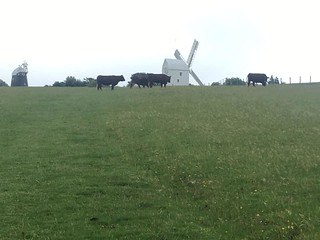
This is an exhilarating walk along the South Downs Way, a ridge of South Downs chalk grassland with panoramic views inland and out to the sea by Brighton. On the way up to the ridge, the route passes Butcher's Wood and visits a church in Clayton and a still-working Clayton Windmill. The friends of Jack and Jill windmill sometimes serve tea on weekends. On the South Downs Way you pass medieval dew ponds and an Iron Age fort at Ditchling Beacon. After lunch, down below in Plumpton, you climb back up onto the downs, before a final walk into Lewes along the River Ouse, then up to the Norman castle and through its gateway into the ancient High Street. This is an easier walk, with far fewer ups and downs, than Walk 25 from Winchelsea to Hastings. It's a great picnic walk, as the pub is at the bottom of the ridge, and it would save you descending from the ridge to the pub, then climbing back up again afterwards |
| Walk Options |
There are summer buses from Brighton to Ditchling Beacon. Or, from the lunch pub in Plumpton, you could catch a bus to Lewes, but the buses do not run on Sundays. See Traveline Southeast. Plumpton railway station is about 3 kilometres from the lunch pub. You could stay on the ridge, and miss out the lunch pub, a little shorter, and much easier Chattri MemorialJust after the windmills, if you have a map, you can can make an out-and-back diversion, south for about 1km to the Chattri [Wikipedia] - a moving memorial to Indian soldiers who died of their injuries while at the Brighton Pavilion hospital during the 1st World War. According to their faith, soldiers were cremated here, or buried at Woking Mosque. Old Hamsey ChurchA short out-and-back detour towards the end of the walk leads to Old Hamsey Church on hillock on an island in the Rover Ouse which predates the Norman Conquest. Once a port town, King Athelstan held a meeting here in 925. In the early 1,000's, maybe as result of the river silting up, or a plague, the town was moved to Offham, a mile or so to the north, and the church was only used as a chapel for the village cemetery. The current medieval structure dates to the 12th and 14th centuries, untouched by Victorian "restoration". Friends - history |
| History |
The Saxon Church of St John the Baptist in Clayton has eleventh or twelfth-century wall paintings and an entrance path whose rippled effect comes from stone quarried from the fossilised bed of a sea or a river. One of the Clayton Windmills ('Jill'), a post mill, with its 1852 'Sussex Tailpole' on wheels for changing direction, is normally open to visitors from 2pm to 5pm on most Sundays from May to September and also at certain other times; check on www.jillwindmill.org.uk. Ditchling Beacon, once an Iron Age fort, with traces of ramparts still visible, was a site for one of the beacons that gave warning of the Spanish Armada. Anne of Cleves House is a 15th century timber framed Wealden Hall. It formed part of Queen Anne's annulment settlement from King Henry VIII in 1541, although she never stayed in the House or visited it. The House is open to the public, Tuesday to Sunday, from 10am to 5pm. Admission 2023 is £ 6.60. A combined ticket with admission to Lewes Castle is available - see below. Lewes Castle (tel 01273 486 290), and the Barbican House Museum nearby, are open to visitors, daily, 10am to 4pm, November to February, and 10am to 5pm, March to October, with last admissions 30 mins before closing. Admission (2023)is £10. A combined ticket with Anne of Cleves House is available - check at the Castle Admission for cost. The castle was built by William de Warenne, who fought alongside William the Conqueror at the Battle of Hastings. Its towers were added about the time of the Battle of Lewes. In this battle in 1264, the rebel earl, Simon de Montfort, with an army of Londoners and 5,000 barons, defeated Henry III, who had two horses killed under him and was forced to seek refuge in Lewes Priory. The Mise of Lewes was signed next day and led to England's first parliamentary meeting at Westminster in 1265. The church at Lewes Priory was larger than Chichester Cathedral but was demolished during Henry VIII's dissolution of the monasteries. Only ruins of the priory remain. The churchyard of St John Sub Castro ('Under the Castle') has an obelisk commissioned by Tsar Alexander II to commemorate the 28 prisoners of war who were captured during the Crimean War and who died in Lewes Gaol in the 1850s. Tom Paine (1737-1809), author of The Rights of Man, lived in Lewes, and his political debating society, the Headstrong Club, often met at the White Hart Hotel. He subsequently participated in both the American and French Revolutions. |
| Travel |
Take the train nearest to 9.30am from Victoria to Hassocks (there are also direct trains from London Bridge). Journey time about 50 minutes. Trains back from Lewes to Victoria run twice an hour (hourly on Sundays) and take 1 hour 7 minutes. Buy a day return to Lewes. Car drivers: Park at Hassocks Station (not free), or a little along the route (free). You'll need to change trains at Wivesfield to return to your car. |
| Lunch |
The suggested lunchtime pub is the Half Moon (tel 01273 890 253) in Plumpton, some 9.3 km into the walk, which welcomes walkers and serves food from midday to 2.30 pm Monday to Friday, from midday to 3 pm on Saturday, and midday to 6 pm on Sunday; groups of 4 or more people should phone to book and booking for all at weekends is recommended. The pub has pleasant internal and outside dining areas. The menu consists of starter plates, main plates, daily specials, ploughmans, sandwiches, plus a good selection of puddings. The pub usually provides the discerning drinker with a good range of draught beers. If you feel like something before lunch, you may be able to buy ice cream from the van which is normally parked at Ditchling Beacon. |
| Tea | There are a number of possible places to have tea in Lewes but a comfortable one, serving tea and pastries, is The White Hart Hotel (tel 01273 476 694), 55 High Street. You also have Ask restaurant (tel 01273 479 330), open till late, and in the pedestrianised part of the High Street there is a branch of Bills and more pubs and cafes. The Harvey's local brewery has a number of pubs and outlets in town. On the London bound platform of Lewes Railway station is a very good cafe, the Runaway. |
| Updates |
No major changes. Minor tweaks and minor updates. Directions, opening times and prices to attractions, last updated April 2023. |
| Book |
This walk was originally published in Time Out Country Walks near London volume 1. We now recommend using this online version as the book is dated. The book contained 53 walks, 1 for every week of the year and 1 to spare. Here is our suggested schedule |
|---|---|
| South Downs Way |
This walk is one of 9 stages of the South Downs Way - a 109 mile national long distance path - that traverses the South Downs National Park in South East England. |
| Profile | |
| Help Us! |
After the walk, please leave a comment, it really helps. Thanks! You can also upload photos to the SWC Group on Flickr (upload your photos) and videos to Youtube. This walk's tags are: |
| By Train |
Out (not a train station) Back (not a train station) |
| By Car |
Start BN6 8JD Map Directions Return to the start: Finish BN7 2UP Map Directions Travel to the start: |
| Amazon | |
| Help |
National Rail: 03457 48 49 50 • Traveline (bus times): 0871 200 22 33 (12p/min) • TFL (London) : 0343 222 1234 |
| Version |
Apr-23 Marcus |
| Copyright | © Saturday Walkers Club. All Rights Reserved. No commercial use. No copying. No derivatives. Free with attribution for one time non-commercial use only. www.walkingclub.org.uk/site/license.shtml |


Walk Directions
- [1] Coming off platform 2 at Hassocks Railway Station, go down the station approach road. In 35 metres you pass The Hassocks pub on your left and take the tarmac path to your right , signposted South Downs, with a brick wall on your left.
- In 25 metres you come to the B2116 road and go right along its pavement towards the railway bridge but before you reach it, in 40 metres, cross over the road and by a bus stop go left on a footpath signed South Downs.
- An alternative, somewhat more straightforward route is to go past this footpath and after 10 metres turn left through brick pillars on an unmarked path that continues with the railway on your right for 250 metres till you rejoin the main route at [*].
- For the main route, go ahead on the first path, your direction 190°. Ignore ways off and in 150 metres you cross a tarmac road to go on, slightly to the right, following a footpath sign, your direction due south.
- In 100 metres you come to a T-junction with a three-armed footpath sign where you go left, your direction 205° with the railway embankment wall on your right. [*]
- In 10 metres ignore the tarmac path on your left and keep ahead, initially with garden fences on your left and the embankment wall on your right. 200 metres a pleasant detour (unless muddy underfoot) is to go through a gate to your left into the Woodland Trust’s Butcher’s Wood (marked in the OS map) and then to keep on, in the same direction as your previous route. In 250 metres go through a kissing gate to rejoin the previous path. 25 metres after rejoining the route, ignore a squeeze stile and footpath to the left.
- In 175 metres go over a cross paths and ignore the path on the right which goes over the railway line.
- [2] After 225 metres you leave the wood and can see the Downs ahead with the Clayton Windmills to the left. In a further 400 metres you come to the A273 road where you go left. (There is an interesting turreted house to your right on the far side of the main road.) In 35 metres cross the B2112 road to Ditchling and go through the wooden kissing gate opposite, heading due south over a sports field towards the Church of St John the Baptist, Clayton (worth a visit). Turn left at the hedge and walk past the back of a building on your left for 5 metres to go through a gap in the hedge on your right on to a road, opposite the church.
- Go left on the tarmac road (or if you visit the church come out of the lychgate and turn right).
- In 120 metres, as the road swings left,turn right on a signposted bridleway through the entrance to Clayton Court Stables, your direction 185° on a wide track, steadily uphill towards the windmills, with a tree line on both sides.
- The path becomes steeper and in 150 metres go though a wooden swing gate to come out into the open. Here turn half-right and continue on the uphill path, due south. You pass through a metal swing gate as you continue ahead until you reach the top of the ridge, then keep going until you reach the nearest, white Jill Windmill Clayton. Its car park is on your right.
- Go past the wooden kissing gate giving access to the car park and then go through a wooden swing gate onto a signposted fenced-in footpath along the left-hand side of the windmill gardens, your direction 130°. Veer right with the path beyond the top, black Jack Windmill and cross over a farm track to an earth road T-junction by a two-armed sign post. Turn left, your direction 115° onto a wide bridleway, The South Downs Way .
- [3] In 120 metres take the left fork, your direction still 115°. In 15 metres go through a metal fieldgate and head steadily uphill, now on a chalky track.
- In 650 metres ignore a bridleway to the right, pass metal fieldgates on either side and stay on the South Downs Way, gently uphill. You now have extensive views both to the left and towards the sea over on your right. In 350 metres ignore another bridleway to your right
- This bridleway leads about 1.5km south on a out-and-back detour to the Chattri Memorial
- Keep ahead as the South Downs Way levels out. In 40 metres ignore the wooden swing gate to your left and in 20 metres you pass a four-armed sign in a field on the left, pointing onwards to Eastbourne; this is the Keymer Post which also points left to Keymer Village. In 15 metres go through a wooden swing gate and continue straight on, as the ridge now starts to go downhill, on a broad grassy way.
- In 250 metres go through another wooden swing gate to the left of a metal fieldgate and pass a dew pond on your left (Burnt House Pond). You now have gorse bushes over to your left.
- In 250 metres you pass another dew pond, this time on your right. [4].
- In 325 metres go through a wooden swing gate to enter Ditchling Beacon Nature Reserve to keep ahead, now with a fenceline on your right as the ridge narrows. In a further 300 metres you pass a tall direction post on your right by a wooden swing gate and you continue straight on. In a further 150 metres you pass a triangulation point over to your right (marked on the OS map).
- In 125 metres you reach Ditchling Beacon, the site of an early Iron Age fort. There is a car park with a notice about the site and usually an ice cream van. Walk through the car park to the road which you cross. Pass through the wooden swing gate on the far side, following the South Downs Way sign, onto a broad grassy ridge way, following a fenceline on your right, and with a dew pond also on your right.
- In 400 metres by a three-armed footpath post on your right ignore a bridleway down to the right and in 30 metres ignore an unmarked path to the left. You now have a good view of the Amex Stadium (home of Brighton and Hove Albion FC) over to your right and in a further 160 metres, at the top of an incline, you may be able to see Brighton and the sea beyond it, also to your right.
- Continue along the ridge for a kilometre. Ignore a wooden swing gate and a path to the left, by a three-armed footpath sign and in 250 metres go through a wooden swing gate, cross a tarmac lane and with a three-armed footpath sign on your right go straight on , to pass through a gap to the left of a wooden fieldgate. Ignore all ways off, now on a earth and chalky path between fences, gently uphill.
- [5] In 330 metres, by a four-armed footpath sign, you reach a fork on the left where you have a choice: you can go down to the pub in Plumpton for lunch or stay on the Downs.
- If you do not want a pub lunch you can continue to walk along the ridge and there are many places where you could stop for a picnic (one good one is just before the fork where you can go through a kissing gate to a grassy bank with great views). If not going to the pub, continue ahead for 1.5 kilometres when you reach a five-way footpath sign at a gate. Go through the gate and continue ahead for about 400 metres to the triangulation point where you are again on the main route marked [**].
- For a pub lunch and the main route, take the left fork and head downhill on an unasphalted road, your direction 75°. [!] warning: this road can be slippery in the wet. In 440 metres ignore a bridleway off to the left and ignore all other ways off.
- In a further 370 metres you come to the B2116 road and turn left. The suggested lunch stop, 40 metres away on the other side of the road, is the Half Moon pub in Plumpton.
- If you do want to reduce the walk at this stage by taking a train from Plumpton, go on the footpath from the top corner of the pub’s garden and it will take you all the way to the station, eventually, but it is 2 miles away, due north of the Half Moon pub.
- For the main route, coming out of the pub after lunch, go left on the B2116 road. In 40 metres ignore the bridleway on which you came down before lunch. In a further 50 metres veer right to pick up the path parallel to the road.
- In 70 metres pass by a redundant stile and come out into an open field. Here [!] turn half-right on a clear path, your direction 140°, heading towards the Downs. In 195 metres go over a step stile and bear half-left over a field and in 65 metres go over another step stile to enter a wood.
- In 15 metres you come to a larger path T-junction where you turn right uphill, your direction 140°.
- After 65 metres take the left fork (almost directly ahead). Soon you are in a shallow woodland cutting. In 150 metres as you go up on the edge of the wood, enjoy the view at the opening to your left and carry on up. After another 150 metres, ignore the footpath marked with a yellow arrow to your left.
- In 170 metres go through a metal fieldgate (off its hinges, May 2017) and on upwards. In 135 metres, having left the woods, you cross a chalk road by a footpost marker to go on up, steeply, your direction still 140°.
- After 80 metres pass through some trees and bushes to reach a bridleway: you are back on the South Downs Way. Turn left, your direction 100° on a broad grassy way, with woodland and gorse bushes to your left.
- [**] In 130 metres you pass a triangulation point (marked on the OS map) on your left.
- Continue on but after 50 metres, [!] fork left on a grassy path, downhill, towards some low trees, your direction east. After 110 metres at the bottom of the slope ignore a path heading downhill to your left and keep ahead as the path begins to go uphill, with woodland to your left and intermittent trees and bushes to your right. In 270 metres at the top of the slope pass a beacon post on your right, and continue ahead, due east, soon going gently downhill.
- In 175 metres go through a wooden swing gate and continue ahead, your direction 130° gently downhill on a broad grassy way. You can now see ahead of you the outskirts of Lewes.
- In 280 metres go under pylons and swing right with your way, downhill. In 70 metres you pass between a few trees on your right and woodland to your left to come out onto a path, with a fenceline on your right, and woodland over to your left.
- Keep ahead along this path, following the fenceline on your right as you head towards some buildings ahead, your direction 155°.
- In 50 metres ignore a faint path to the left into trees and continue on. In 170 metres go through a wooden swing gate and keep ahead, still with the fence on your right and the wood over to your left, your direction 120°.
- In 400 metres you come to a cross paths junction, with a footpost on your left with three blue arrows. Here turn left downhill into the wood, your direction 30°. In 40 metres, you turn right on to the main path, your direction now 80°.
- In 150 metres go through a wooden swing gate and keep ahead. In 50 metres ignore a footpath leading to a stile on your right. 60 metres further on, go through a wooden swing gate on your right and turn left onto a chalky track, downhill, in the same direction as before, 30°. [!] warning: this track can be slippery in the wet.
- Carry on steadily downhill for 450 metres until you reach the A275 road. Here turn left. In 50 metres cross the road and turn right on The Drove road. In 15 metres you pass the entrance to The Parish Church of St Peter at Offham (the church is usually locked).
- In 35 metres, as the road swings to the left, take the signed path ahead, an earth track, muddy in winter, going due south, steadily downhill. In 180 metres go under pylons. In 25 metres ignore a path to the left. In a further 320 metres, at the bottom of a slope, at a cross tracks turn left and in 15 metres pass through a wooden kissing gate, with a wooden fieldgate to its left, crossing a waterway, your direction 95°, and keep ahead over a grassy field.
- In 280 metres go through a wooden swing gate, with a metal fieldgate to its left. In 20 metres go under a main railway line and after 20 metres go through another wooden swing gate.
- Old Hamsey Church : For an out-and-back detour to visit the medieval church, turn left along the river for 1km (the path leaves the main river and continues along a stream), then turn right along a signposted track for 250m to the church.
- In 15 metres turn right to go through a pair of wooden swing gates. Continue on along the bank of the River Ouse which is on your left. You can now see Lewes Castle ahead of you. You are now on an embankment recently constucted by the Environment Agency as a flood defence against the River Ouse bursting its banks. The top of the embankment has a gravel finish which makes for a major improvement for walkers who previously had to negotiate an (at times) very muddy riverside path all the way to the outskirts of Lewes.
- In 150 metres go through a wooden swing gate to the right of a metal fieldgate and continue along the top of the new embankment. After 200 metres you pass Old Malling Farm (marked on the OS map) on the opposite bank.
- In a further 470 metres you glimpse the seventeenth century St Michael’s Church on the other bank. In another 120 metres, go through a wooden kissing gate.
- After 230 metres ignore the footbridge crossing the river to your left. Instead, turn right onto a tarmac path with a wall on your left.
- In 80 metres you begin to pass a body of water on your right. In a further 80 metres you pass the entrance to Pells Open Air Pool and a children’s park on your left. At the end of the park, cross the tarmac road (Pelham Terrace) and continue up the road in front (St John's Hill). In 80 metres turn left past the entrance to St John Sub Castro Church. Now go right on Abinger Place, towards the Elephant and Castle pub visible ahead.
- In 100 metres, with this pub on your right, cross the main road (or cross at the pedestrian crossing 20 metres to your right) and continue straight on up along a tarmac lane (Castle Banks), your direction 220°, with scaffolding pole railings on your left.
- In 80 metres you come to the top of this lane and at the T-junction with The Maltings opposite, turn right, your direction 255°. In 15 metres you pass a notice away on your right about the Battle of Lewes in the year 1264 and then, under a beech tree, a plaque commemorating Tom Paine . Follow the tarmac road going around to the left towards the castle, your direction 195°.
- In 80 metres you pass the entrance to an ancient Bowling Green, formerly the Castle Tilting Ground on your left. In 25 metres you pass through the Barbican Gate and then go past the entrance to Lewes Castle on your right and Barbican House Museum on your left.
- 10 metres beyond these you come to the High Street. (Turning right here leads in 110 metres to the fifteenth century Bull House where Tom Paine lived and beyond it on the right the Casbah café). But on the main route, turn left.
- In 130 metres you come to the White Hart Hotel on the right-hand side of the road. A little further up, on the left side, is Ask restaurant. For an additional choice of pubs and cafes keep ahead at the traffic lights and head towards the pedestrianised High Street.
- Otherwise, at the traffic lights turn right on Station Street. This road leads straight downhill to Lewes Railway Station, visible ahead (platform 2 for trains to London).
- But if you have half an hour to spend before the train goes, you might care to visit Lewes Priory. Coming out of the Garden Room Café, instead of going straight ahead to the station, turn right on Southover Road. Pass Garden Street on the left and immediately go left into Grange Gardens and wander through these (parallel to Southover Road) to emerge again on Southover Road at the far end. Then turn left into Southover High Street. At the T-junction turn right, soon passing St John’s Church on your left. Then turn left on Cockshut Road, go under the railway line and turn left towards the priory ruins. Pass to their right. Leave the site through a gap in the wall on the right and then follow a wall on your left. After passing a mound on your left turn left into a path. Then go left over the railway and right to the railway station.