Greensand Way 9 : Harrietsham or Sutton Valence to Pluckley Walk
Greensand Way Stage 9 - fine views from a gentle ridge, orchards and nice pubs

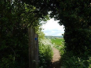
Buttercup stile near Pluckley
Sutton Valence to Pluckley walk
May-15 • Saturdaywalker on Flickr
swcwalks swcwalk151 walkicon banner 17431799413
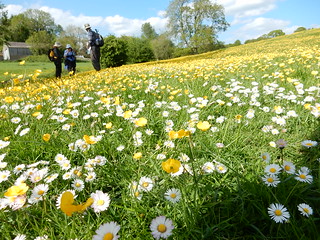
Buttercups and daisies
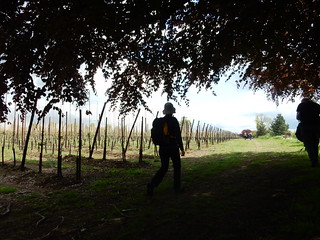
Sutton Valence to Pluckley
kent pretty greensandway walkicon swcwalks swcwalk151 17583521599

The Pepper Box Inn
Sutton Valence to Pluckley walk
Mar-22 • Saturdaywalker on Flickr
swcwalks swcwalk151 walkicon 51986866758
| Length | Starting from Sutton Valence: 17.7km (11 miles) Starting from Harrietsham: 15.9km (9.9 miles) |
|---|---|
| Toughness | 3 out of 10 with 630 ft (200 meters) of ascent. Gently undulating mainly short climbs. A gentle climb to the Greensand Ridge on the Harrietsham start. |
| Maps |
OS Explorer Map : 137 |
| Features |
This is a very pleasant, gentle section of the Greensand Way, going through typical Kentish countryside that includes apple orchards, pasture, a series of interesting churches attached to farms or manor houses, and fine escarpment views. For the most part the route is waymarked, but the waymarks have an annoying habit of disappearing at crucial points in the walk, hence these directions. In places the path crosses arable fields or goes down the edge of orchards which could potentially be very muddy in winter, particularly as agricultural machinery is used in the orchards which can churn up the ground. There is sadly some evidence of orchards being grubbed up at present. There are a couple of modest bluebell woods, flowering in late April or early May. The central part of the walk (from the Pepper Pot Inn to Egerton) runs about 2km to the south of the M20 motorway, which can produce a noticeable hum of noise if the wind is in the east or north. In such conditions there is also traffic noise on the Harrietsham start, which crosses the M20 motorway and heads southwards. However when the wind is southerly or westerly noise is minimal in both cases. |
| Walk Options |
|
| Travel |
For the Sutton Valence start, take the twice hourly train from London Charing Cross, Waterloo East or London Bridge to Headcorn. Buy a day return to Pluckley. The Arriva Bus 12 leaves from a stop on the main road at the top of the station approach, destination Maidstone. See arrivabus.co.uk for the latest bus times. Currently (2025) there are two buses an hour Monday to Friday, so any train connects fairly neatly with a bus on those days, but only one bus an hour at weekends. On a Saturday the 9.34 train from Charing Cross has a good connection with the hourly bus, while on Sundays it is the the 04 past. The bus fare is currently £3.00 (a government-mandated flat fare). If you miss a connection in Headcorn and have some time to wait for the bus, you can walk into the village and get the bus from there: go down the station approach and turn left on the main road for 400 metres or so to come to the very pretty village centre. The bus stop for Sutton Valence is opposite (on the other side of the road from) the George & Dragon Inn. For the Harrietsham start, take the train (one an hour) from London Victoria to Harrietsham. The 9.25 will get you to the Pepper Box Inn at about 12.15pm. A day return to Pluckley might be accepted on this route if you explain you are on walk (it is on a different line entirely, but both are operated by Southeastern). Alternatively you can play safe by buying a day return to Ashford International, which is definitely valid for both lines but quite a bit more expensive. There are currently two trains an hour back from Pluckley (one an hour on Sundays). |
| Lunch |
The Pepper Box inn in Fairbourne Heath (01622 842558), 5.3km (3.3 miles) from Sutton Valence and 3.5km (2.2 miles) from Harrietsham, is currently the only lunch pub for this walk. It is a very popular pub with excellent food at the junction of the two alternative starts for the walk. It is closed on Mondays, but serves food 12pm-2.15pm and 6-9pm Tuesday to Saturdays and 12-3pm on Sundays, with the pub open for drinks from 11.30am-3pm and 6pm-11pm Monday to Saturday and 12-5pm Sundays. Most of the inside is devoted to table service and even on weekdays it can be quite busy. However, there is an extensive area of outside tables which is accessible to non-reserved customers. A later option used to be the George in Egerton, 11.8km (7.3 miles) from Sutton Valence, 10km (6.2 miles) from Harrietsham, but in early 2025 this seemed to have permanently closed. |
| Tea |
Reachable by a 1.2km diversion off the walk route just before Pluckley village (directions given in the written walk directions), the Rose & Crown (01233 840048) in Mundy Bois, is a pub in a delightful rural location, with comfortable sofas and a garden with charming views of the fields. It is open all afternoon daily for drinks, and serves food all afternoon Saturdays and Sundays, and from 12pm-2.30pm and 6pm-9pm Monday to Friday. The Black Horse, Pluckley, towards the end of the walk, is open all afternoon for drinks till 8pm Wednesday and Thursday, late evening Friday and Saturday and till 6pm Sunday. Food is served 12-8pm Friday and Saturday and 12-4pm Sunday. It is closed Mondays and Tuesdays. The Dering Arms (01233 840371) by Pluckley station is a former hunting lodge which is now an award-winnning seafood restaurant. Booking is necessary to eat there, but you can have drinks in its cosy bar area and also at a few outside tables. It is open to 3pm and from 6pm Tuesday to Saturday, but only until 4.30pm on Sundays. Closed Mondays (including bank holidays). |
| Greensand Way |
This walk is one of 11 stages of the Greensand Way - a regional long distance path in the Southeast of England |
|---|---|
| Links |
|
| Profile | |
| Help Us! |
After the walk, please leave a comment, it really helps. Thanks! You can also upload photos to the SWC Group on Flickr (upload your photos) and videos to Youtube. This walk's tags are: |
| By Train |
Out (not a train station) Back (not a train station) |
| By Car |
Start Map Directions Return to the start: Finish Map Directions Travel to the start: |
| Amazon | |
| Help |
National Rail: 03457 48 49 50 • Traveline (bus times): 0871 200 22 33 (12p/min) • TFL (London) : 0343 222 1234 |
| Version |
Mar-25 Peter |
| Copyright | © Saturday Walkers Club. All Rights Reserved. No commercial use. No copying. No derivatives. Free with attribution for one time non-commercial use only. www.walkingclub.org.uk/site/license.shtml |


Walk Directions
Full directions for this walk are in a PDF file (link above) which you can print, or download on to a Kindle, tablet, or smartphone.
This is just the introduction. This walk's detailed directions are in a PDF available from wwww.walkingclub.org.uk