Beeches Way: West Drayton to Cookham Walk
Lowland heaths and mature woodland close to London. Can be done as 2 shorter walks.

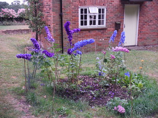
Delphiniums near Sheepcote Woods
SWC Walk 189 Beeches Way: West Drayton to Cookham
Jul-15 • thomasgrabow on Flickr
swcwalks swcwalk189 walkicon banner 19662895575

Beech colour
Langley to Cookham walk
Nov-23 • Saturdaywalker on Flickr
swcwalks swcwalk189 banner walkicon 53359999306

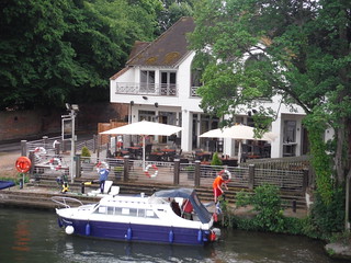
One of 6 Pubs en-route in Cookham
SWC Walk 189 Beeches Way: West Drayton to Cookham
Jul-15 • thomasgrabow on Flickr
walkicon swcwalks swcwalk189 19474799560

Ancient Pollarded Tree in Burnham Beeches
SWC Walk 189 Beeches Way: West Drayton to Cookham
Jul-15 • thomasgrabow on Flickr
walkicon swcwalks swcwalk189 19655879702

Path in Brockhurst Wood
SWC Walk 189 Beeches Way: West Drayton to Cookham
Jul-15 • thomasgrabow on Flickr
walkicon swcwalks swcwalk189 19636845406
| Length |
Beeches Way (Cookham to West Drayton) : 17.0 miles ( 27.3 km). Can be done as 2 shorter walks of around 8 miles by using buses Langley to Cookham : 13.7 miles (22.1 km). This is the recommended option - it misses out the (less interesting) M25 and canal parts of the walk. |
|---|---|
| OS Map |
Explorer map 172 - Chiltern Hills East |
| Toughness |
5 out of 10. Well waymarked. Good paths. Just long. |
| Features |
This 17 mile route, from the Thames at Cookham to the Grand Union Canal at West Drayton explores rare lowland heaths and mature woodlands, escaping “Far from the madding crowd's ignoble strife” (Thomas Gray 1750) The walk can be followed in either direction. It is fully waymarked, and marked by chevrons on OS maps. NB The short sections from the river to the stations at either end of the walk are not part of the way, and so are not waymarked. We recommend a slightly shorter option, Langley to Cookham, as this cuts out the M25 and the less interesting start of the walk. Cookham has nice pubs to finish at, and await your train home. The route passes:
The GPS route (see warning icon on the map page) has a detour from the official route near West Drayton due to a collapsed canal bridge. This adds a mile of road walking, another reason to start/finish at Langley. |
| Walk Options |
The walk is too long for most people, so here are some options to shorten it, or do it in to stages Note: The rail line from Paddington passes (in order) West Drayton, Iver, Langley, Slough (for buses to villages on the route), Maidenhead (for the branch line to Cookham) and Cookham (change at Maidenhead). Langley to Cookham : 13.5 miles recommeded optionThis is the best summer option, but you do miss out the eastern end of the walk (the M25, and the canal). In this case its best to walk towards Cookham which has nicer pubs to aim for. Starting at Langley saves 3.3 miles. You could also start fom Iver Station, but this only saves 1.5 miles Cookham to Stoke Poges (bus stop) : 8.5 milesStoke Poges (bus stop) to West Drayton : 8.5 milesThe walk can be split into 2 shorter sections by using buses. Splitting the walk at Stoke Poges would make two equal walks of 8.5 miles, but it only has rare buses (none on Sunday). It would be best to catch the bus from Slough station in the morning (when you can time your train to connect with it) to Stoke Poges, and start the walk from there. Slough's bus station is next to the train station. Other bus stops on the route are:
Langley to Burnham station : 11-12 milesThis option has been done by some walkers and involves cutting south through the woods just beyond Farnham Common and then following Crow Piece Lane. Bucks Council have a leaflet with map extracts describing the walk. |
| Travel |
Hourly Trains from London Paddington (passing West Drayton) to Maidenhead, where you change for Cookham, take around 1 hour. West Drayton is in London Zone 6, and has at least 2 trains an hour to Paddington Farnham Common (after 6 miles) : The 74/X74 go to Slough station (on the same rail line), take 15 mins. Regularly on Mon-Sat, but check the time of the last bus on Sunday Poges (after 8 miles) : Rare buses (#353, 2 hourly) on Mon-Sat. None on Sunday. Bus stop is on the route, but pub is 1km south in the village centre. Fulmer (after 11 miles) : Rare buses (#335, 2 hourly) on Mon-Sat, None on Sunday Iver : Does have buses, but its only a 1 km walk to the station, saving 1.5 miles for a total of 15.5 miles. Suggested Train : early, as its a long walk |
| Eat |
There are lots of refreshment options on this walk: West Drayton has 3 station pubs. The Blues bar is the pick of them Iver : A couple of pubs to choose from Langley Park Visitor Centre has a cafe Between Langley Park and Fulmer there is a cafe with a large terrace overlooking Blackpark Lake. Fulmer : The Black Horse - a very pleasant pub with a nice garden Stoke Poges : pub 1 km south of the route, in the town centre Farnham Common: The Forresters 01753 643340. Excellent large pub with real ales. The Beeches Cafe: this is at the end of the car park for Burnham Beeches, a few hundred metres beyond the village of Farnham Common. Farham Common's main street also has a Costa Coffee and both a Tesco and Sainsbury Express. Perhaps too late for lunch but a nice refreshment stop, the Blackwood Arms on Littleworth Common is a charmingly-sited traditional pub with outside tables surrounded by grass and trees Cookham: The suggested stop for tea in Cookham High Street is Infusions (tel 01628 528 537), a delicatessen with a garden where you can eat your purchases. There is also the Teapot Tea Room just beyond the King's Head. Other options are the seventeenth-century hostelry, the Kings Arms (tel 01628 530 667), open daily until at least 9pm (serves food from noon) and the Bel and the Dragon pub (tel 01628 521 263), both also in the High Street: also the Crown, at the west end of the High Street which has outside tables overlooking Cookham Moor. In addition, there are two pubs which you pass on your way to the railway station, the Countrystore shop opposite the station, and a Costa Coffee just beyond the station level crossing. |
| Profile | |
|---|---|
| Help Us! |
After the walk, please leave a comment, it really helps. Thanks! You can also upload photos to the SWC Group on Flickr (upload your photos) and videos to Youtube. This walk's tags are: |
| By Train |
Out (not a train station) Back (not a train station) |
| By Car |
Start Map Directions Return to the start: Finish Map Directions Travel to the start: |
| Amazon | |
| Help |
National Rail: 03457 48 49 50 • Traveline (bus times): 0871 200 22 33 (12p/min) • TFL (London) : 0343 222 1234 |
| Version |
Mar-17 Andrew |
| Copyright | © Saturday Walkers Club. All Rights Reserved. No commercial use. No copying. No derivatives. Free with attribution for one time non-commercial use only. www.walkingclub.org.uk/site/license.shtml |
