Petts Wood Circular Walk
Easy and pleasant walk through woodlands nestled in the middle of London's South-Eastern suburbs

photo
May-21 • hikinginlondon on Flickr
swcwalks swcwalk309 petts wood southeastern hike walk scadbury park chislehurst caves london woodlands 51917239661

photo
May-21 • hikinginlondon on Flickr
swcwalks swcwalk309 petts wood southeastern hike walk scadbury park chislehurst caves london woodlands 51917567139

photo
May-21 • hikinginlondon on Flickr
swcwalks swcwalk309 petts wood southeastern hike walk scadbury park chislehurst caves london woodlands 51916273577

photo
May-21 • hikinginlondon on Flickr
swcwalks swcwalk309 petts wood southeastern hike walk scadbury park chislehurst caves london woodlands 51917861195

photo
May-21 • hikinginlondon on Flickr
swcwalks swcwalk309 petts wood southeastern hike walk scadbury park chislehurst caves london woodlands 51916273832
| Length | 12km (8m) |
|---|---|
| OS Map | Explorer Map 162 |
| Toughness | 1 out of 10 |
| Walk Notes | This is an easy and pleasant walk through woodlands nestled in the middle of London's South-Eastern suburbs. The initial 36ha of Petts Wood were saved by locals from developers in the early part of the 20th century and donated to the National Trust. The Western part and the Hawkwood estate were donated by the land owners to the Trust in 1957. Scadbury Park has been in private ownership for centuries until it was bought by Bromley Council in 1983. Bromley Council declared it a Nature Reserve and opened it to the public. In Petts Wood there is a memorial to William Willett who built many houses in South-East London and campaigned for the introduction of Daylight Savings Time. Scadbury Park was for some time owned by the Walsingham family who had close relationships with Tudor monarchs including Elizabeth I. The ruins of their moated manor house can still be seen and are now maintained by the Orpington and District Archaeological Society. An optional extension leads you to the Chislehurst Caves (also see here), old flint and chalk mines which were dug starting in the 13th century until mining stopped in the 19th century. More recently the caves have been used as air raid shelters in WWII, for locations for TV and film and concert venues. The caves are open Wed to Sun, 10:00 to 16:00 with hourly tours. |
| Travel | Take the train nearest to 10:00 from London Charing Cross or London Victoria to Petts Wood. Petts Wood is in Zone 5 and Osyter Cards can be used. |
| Lunch | The Bull's Head in Chislehurst (02084671727) |
| Tea | Various cafes, tea rooms and pubs in Petts Wood. Cafe X on the eastern side of the station is recommended. |
| Profile | |
|---|---|
| Help Us! |
After the walk, please leave a comment, it really helps. Thanks! You can also upload photos to the SWC Group on Flickr (upload your photos) and videos to Youtube. This walk's tags are: |
| By Train |
Out (not a train station) Back (not a train station) |
| By Car |
Start Map Directions |
| Amazon | |
| Help |
National Rail: 03457 48 49 50 • Traveline (bus times): 0871 200 22 33 (12p/min) • TFL (London) : 0343 222 1234 |
| Version |
Feb-22 Dirk |
| Copyright | © Saturday Walkers Club. All Rights Reserved. No commercial use. No copying. No derivatives. Free with attribution for one time non-commercial use only. www.walkingclub.org.uk/site/license.shtml |
Walk Directions
- Walk up onto the railway bridge, turn right and exit the station towards the East.
- Follow the row of shops on your left hand side.
- Turn left into Fairway.
- Cross Petts Wood Road.
- In 100m turn right into Towncourt Crescent.
- In 600m at a T-junction turn left into Hazelmere Road.
- In 50m turn right onto a public footpath.
- Walk underneath the railway lines and take the first path on your right when entering the woods.
- Ignore the first path to the left but in 100m after a wide path joined from the left take the left fork marked by a birch.
- In 100m fork left.
- In 160m ignore a path on the right just before a wide open 4-way junction, where you turn right.
- In 130m at a 4-way junction turn left.
- In 120m at a 5-way junction go straight and pass a bench on the left hand side of the path.
- In 150m at a 4-way junction go straight.
- In 30m after having crossed a wooden bridge turn right onto a small path.
- In 40m at a T junction turn left.
- In 120m at a 5-way junction, where the wood opens up, take the second left up onto a mound. Continue on this path ignoring all crossing paths until your reach a T-junction in 240m where you turn left.
- In 180m ignore a right fork and in another 100m just when you reach the opening with the William Willett memorial sundial turn right, cross a 4-way junction and follow this path ignoring all ways off.
- In 190m at a 4-way junction with the path continuing straight on slightly offset to the right and a large oak on the right corner of the junction, turn right.
- In 260m cross St Paul's Cray Road with care.
- After crossing the road take the first path on your right and immediately cross another path.
- In 210m turn left and pick the path between a concrete pillar and a wooden post in the path, passing the oak tree with the St Paul's Cray Common plaque on the right.
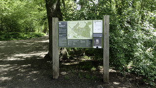
- In 30m, at an information board, turn left into Scadbury Park.
- In 40m turn slightly right joining a wide track with metal mesh covered wooden boards on the ground ahead of you.
- Follow this path ignoring all ways off and in 850m follow the London Loop sign left between wooden fences to the ruins of the 15th century moated manor house.
- After the view of the manor house turn right at the panel in the corner to rejoin the main path in 20m by turning left.
- In 50m take the left fork following the London Loop sign across metal mesh covered wooden boards.
- At a T-junction in 120m turn left and walk through an avenue of trees. Follow the path for 800m ignoring all ways off as it turns left, crosses a valley and then ascends up a hill towards a house. Pass the house and cross a lane through metal kissing gates.
- In 100m you pass a picnic area.
- In 330m you come to a car park. Follow the Acorn Trail sign (in your back when looking at the car park) around a bench to the left of the car park.
- In 750m cross a lane.
- In 80m turn sharp right at a London Loop sign on the left.
- In 100m at a T junction turn right following the London Loop sign.
- In 60m cross a lane. If you do not want to go to the pub, turn left here along the car-wide track and pick up the instructions at number [] : ... cross the road.
- Ignore all ways off until in 150m cross a lane.
- In 90m take the path in the middle towards a wooden barrier on the other side of a lane.
- In 400m you reach the Bull's Head in Chislehurst the recommended lunch pub. St Nicholas Church 100m behind the Bull's Head along Church Road is worth a visit. Also, beyond the Bull's Head Hotel there is a row of shops and restaurants (Indian, several Italians, a F&C shop and a cafe) if you fancy something more formal.
- Coming out of the pub return the way you came for 500m crossing two tarmac lanes until come to a fork about 50m past the second lane, just after a tree leans over the path and where you can see a more open green space ahead of you. Here take the right fork. In a few metres you come to another fork at a large beech where you can take either side. I recommend the left one.
- In 100m turn right and cross the road. In further 40m take the right fork.
- In 140m cross a path.
- In 180m, where a small path crosses from the open area of heather on the left, turn right into the woods.
- In 50m at a T-junction turn left.
- In 80m cross a path and 10m further, at a footpath sign and a plaque of the National Trust announcing that you are now entering the Hawkwood estate turn right downhill with a field on your left.
- In 100m ignore the crossing to a path on your right and turn left in between fences towards a pond.
- In 250m, where the footpath turns slightly left with a wide bridal path next to it, follow the footpath or the bridal path towards the left, whichever is less muddy.
- At a T-junction with a lane turn left.
- In 50m turn right through a metal barrier next to a private entrance to a house.
- In 250m keep right with a field on your right. For adventures types you could also turn left and continue to take the left option wherever possible until you come to the main path at the edge of the wood again where you turn left and continue until you come to the stream in the next item.
- In 400m cross a stream and turn left through a metal barrier. Here you can extend the walk to visit the Chislehurst Caves. This is a 1km-there and 1km-back again deviation. To do so, instead of turning left continue straight, in 50m at the T junction with a lane turn right, in 450m cross a busy road or, more safely, use the bridge to the station and walk up past Chislehurst station, in 350m at the Bickley pub turn right and then follow the signs to the caves (they close at 16:00). You can either return from Chislehurst station or retrace your steps to pick up the walk at the stream again.
- In 500m at a T-junction turn right.
- In 100m the path turns left along the railway lines.
- In 230m climb up onto the bridge to cross the railway lines.
- In 250m cross Little Thrift Road.
- In 350m after crossing another railway bridge turn left. If you feel like walking a bit further you can loop through Jubilee Park ahead of you. A suggestive loop is outlined by the gpx data.
- In 250m turn left out of the car park.
- In 80m turn left into Crest View Drive. You reach the station on your left in 350m.
