South Downs Way 2 : West Meon to Petersfield Walk
A railway path, The South Downs Way, Old Winchester Hill, Butser Hill, Queen Elizabeth Country Park, Buriton and The Hangers Way.

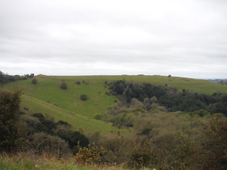
Old Winchester Hill (Ditch, Bank and Barrows) from across the coombe
SWC Walk 183 - South Downs Way Section 2: West Meon to Petersfield
Oct-17 • thomasgrabow on Flickr
swcwalks swcwalk183 banner 37588444781

View along Whitewool Hanger towards West Meon
SWC Walk 183 - South Downs Way Section 2: West Meon to Petersfield
Oct-17 • thomasgrabow on Flickr
swcwalks swcwalk183 walkicon 37588420701

Whitewool Pond Fly Fishing (meonsprings.com)
SWC Walk 183 - South Downs Way Section 2: West Meon to Petersfield
Oct-17 • thomasgrabow on Flickr
swcwalks swcwalk183 walkicon 36877648254

Pub Sign, Ye Olde George Inn, East Meon
SWC Walk 183 - South Downs Way Section 2: West Meon to Petersfield (East Meon Lunch Pubs Diversion)
Oct-17 • thomasgrabow on Flickr
swcwalks swcwalk183 walkicon 37588334571

Harting Downs and Black Down, from Small Down
SWC Walk 183 - South Downs Way Section 2: West Meon to Petersfield (East Meon Lunch Pubs Diversion)
Oct-17 • thomasgrabow on Flickr
swcwalks swcwalk183 walkicon 37539462896
| Length |
17.1 miles (27.5 km) with 1720 ft (525 metres) of ascent
|
|---|---|
| Maps | OS Explorer OL33 (was 133) (Haslemere), OL32 (was 132) (Winchester), OL8 (was 120) (Chichester) and OL3 (was 119) (Portsmouth) |
| Toughness | 9/10 |
| Features |
This walk follows a stage of the South Downs Way (SDW). From West Meon (reached by bus from Petersfield station), it follows the Meon Valley (disused railway) Trail to Exton where it joins the SDW. It heads east, over Old Winchester Hill (an ancient hill fort), Salt Hill, Hyden Hill, Tegdown Hill and Butser Hill (270m), the highest point in the South Downs National Park. After a long descent to cross the A3, it rises through the woods of Queen Elizabeth Country Park (QECP). Here it leaves the SDW to follow the Hangers Way north to Buriton, and back to Petersfield. station The walk is rather long as the stations are badly placed for the route of the SDW, so there are 4 options to shorten it
|
| Author's Note |
This section of the SDW has poor public transport at both ends. At the start, Exton, on the SDW, has rare buses (1 or 2 a week) but they change annually. The West (and East) Meon (north of the SDW) bus service is more reliable. At the end, the walk north to Petersfield station makes the walk too long, hence the shorter options. The best shorter option is the QECP bus stop (on the SDW), but that means buses at both ends. After that, option C, however, it involves crossing the A3 (motorway) via a median. A shortcut via "Petersfield South" A3 junction would mean too much road walking. |
| South Downs Way |
This walk is one of 9 stages of the South Downs Way - a 109 mile national long distance path - that traverses the South Downs National Park in South East England. |
|---|---|
| Walk Options |
For both walks, doing it in reverse is also an option:
|
| Transport |
Winchester and Petersfield are both main stations, about an hour from Waterloo, with 2 trains an hour. However, they are 25 miles - 2 days walking - apart, with very little in the way of public transport in between. In addition, these 2 stations are on different rail lines, which only meet up in Fareham (near Southampton), which makes for a more expensive ticket (2017: London-Fareham: £24.40 vs London-Petersfield: £18.20 - both Network Railcard prices), i.e. a ticket to Fareham is valid for both stations if you need to start your journey in one, and finish it in the other Local Bus services [2021] Stagecoach #67 : Runs between the 2 train stations, but to the north of the SDW.
Stagecoach #37 : QECP Country park to Petersfield
# X17 : Exton (on the SDW) to Petersfield. Very rare, 1 on Wednesday only! Use it to catch a bus to Exton, and then walk back. These seems to change very frequently. Check! Traveline. |
| Lunch and Tea |
En route Winchester - West Meon
En route West Meon - Petersfield
While waiting for the bus
While waiting for the train
|
| Links |
|
| Profile | |
| Help Us! |
After the walk, please leave a comment, it really helps. Thanks! You can also upload photos to the SWC Group on Flickr (upload your photos) and videos to Youtube. This walk's tags are: |
| By Train |
Back (not a train station) |
| By Car |
Start Map Directions Finish Map Directions |
| Amazon | |
| Help |
National Rail: 03457 48 49 50 • Traveline (bus times): 0871 200 22 33 (12p/min) • TFL (London) : 0343 222 1234 |
| Version |
Apr-23 Andrew |
| Copyright | © Saturday Walkers Club. All Rights Reserved. No commercial use. No copying. No derivatives. Free with attribution for one time non-commercial use only. www.walkingclub.org.uk/site/license.shtml |


