Find a Walk
Surrey Hills
Ash to Brookwood
Ash Ranges and Brookwood Cemetery

Box Hill to Leatherhead
Short, 2 steep climbs and the view from Box Hill in the morning, and a gentle river valley after lunch

Denbies Wine Estate
Effingham to Westhumble walk
Mar-16 • Saturdaywalker on Flickr
book2 walk14 walkicon swcwalks 25913989032
Effingham Junction to Westhumble
Polesden Lacy (dramatic NT country house) for lunch, steep woods opening out onto the North Downs Ridge, and an English vineyard for tea
CIMG7441
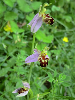
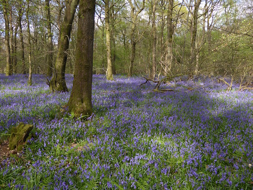
Bee Orchid, Lower Wood
Jul-13 • Sean O'Neill
swcwalk59, swcwalks, walkicon 6401017485186756418 P
Eynsford Circular via Otford
A contrast between hidden valleys in the North Downs and the Darent Valley Path through three interesting villages.

Farnham to Godalming
Pooh Corner. Follow the 3 pigs to find The Donkey!? D.Allen Vivitar 5199 5mp
Jan-06 • magyardave2002 on Flickr
england corner surrey pooh book1 walkers walk12 swcwalks 436684780
Farnham to Godalming
A long but pretty walk with gentle hills via a nice mixture of river valley, forest tracks, and many beautiful country houses.
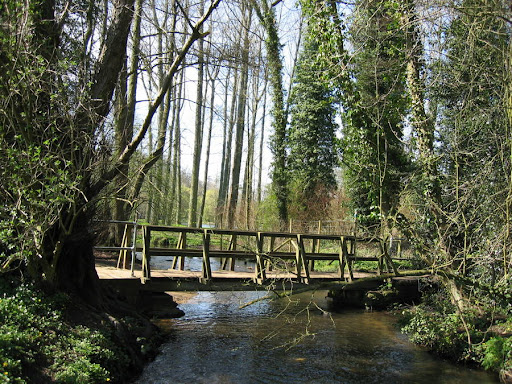
walk 14undefinedbridge over river way
Mar-08 • Bela Struzkova
book1, swcwalks, walk14 5803950311725607538 P
Gomshall to Guildford
Historic Shere, then a walk through a broad wooded valley, then along a canal to historic Guildford
Greensand Way 2 : Witley to Ewhurst Walk
Greensand Way Stage 2 : The Surrey Hills : the Wey Valley, and remote villages
Greensand Hills, Greensand Way, Surrey Hills SWC-Walk-146
Witley to Ewhurst
Greensand Way Stage 2 : The Surrey Hills : the Wey Valley, and remote villages
Black Down, from Holmbury Hill
SWC Walk 147 - Greensand Way Section 3: Gomshall to Dorking
Aug-23 • thomasgrabow on Flickr
swcwalks swcwalk147 banner 53125567998
Gomshall to Dorking
Greensand Way Stage 3 : The Surrey Hills : Holmbury Hill and Leith Hill
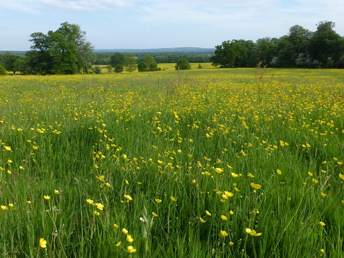
Buttercup meadow, Tandridge
Earlswood to Otford walk
May-15 • Saturdaywalker on Flickr
walkicon swcwalks swcwalk148 18420099968
Earlswood to Oxted
Greensand Way Stage 5 : A gentle ridge walk through a quiet part of Surrey. Regularly spaced pubs.
Greensand Way 6 : Hurst Green to Sevenoaks Walk
The best of the Greensand Way - a traverse of the Chart Hills. Toy's Hill, Ide Hill, Chartwell (NT), and an extension to Knole Park (NT)
Greensand Hills, Greensand Way, Surrey Hills, Knole Palace/Park, Toys Hill SWC-Walk-149
Hurst Green to Sevenoaks
The best of the Greensand Way - a traverse of the Chart Hills. Toy's Hill, Ide Hill, Chartwell (NT), and an extension to Knole Park (NT)

Guildford to Farnham
A river valley, gentle pastures, Watts Gallery, woods, remote heathlands and heather covered moors.
Old Simm's Copse, near Gomshall, Surrey
Apr-17 • Saturdaywalker on Flickr
swcwalks book2 walk13 walkicon banner 34204862186
Guildford to Gomshall
Historic Guildford, The North Downs Way and St Martha-on-the-Hill Church, picturesque Shere. Option to continue along the NDW to Dorking
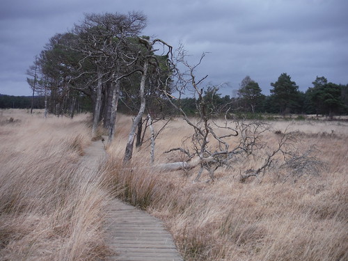
Boardwalk in Pudmore Pond Area, Thursley Common
SWC Walk 144 Haslemere to Farnham - Thursley Common Extension (Pudmore Pond Extension-within-the-Extension)
Feb-17 • thomasgrabow on Flickr
swcwalks swcwalk144 banner 32319666763
Haslemere to Farnham
A wooded ridge, Temple of the Four Winds, Gibbet Hill, Devil's Punch Bowl, Highcomb Bottom, Thursley & Hankley Commons, Atlantic Wall, River Wey, Waverley Abbey's ruins

Holmwood to Gomshall
A very pretty forest walk, quite close to London, and the view from Leith Hill, the highest point in the Southeast.

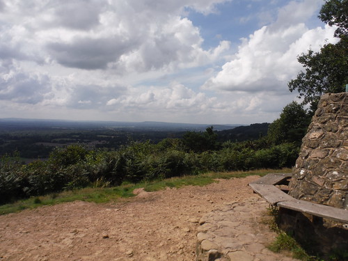
Park Wood, Bench and View on North Downs Way
SWC Walk 111 Caterham to Knockholt (North Downs Way)
Aug-16 • thomasgrabow on Flickr
swcwalks swcwalk111 walkicon banner 28715844513
Caterham to Knockholt
The North Downs Way through woods with fine views - and within Zone 6 (some road noise). Long, with shorter options. Return by bus.

walk_15_pc_Sunlight_on_Coulsdon_Common
Dec-04 • Peter Conway on Flickr
swcwalks book2 walk15 36487165554
Riddlesdown to Coulsdon South
Happy Valley and Farthing Down, close to London (Zone 6)

Witley to Haslemere
A gentle walk to Chiddingfold and the Crown Inn
Region |
Star |
# |
Walk |
Km |
Effort |
Ht. gain |
Description |
London |
|---|---|---|---|---|---|---|---|---|
| Kent | ★ | 59 | Eynsford Circular via Otford | 21.5 | 7 | 450 | A contrast between hidden valleys in the North Downs and the Darent Valley Path through three interesting villages. | TL CX StP V |
| Surrey | 107 | Ash to Brookwood | 15.3 | 5 | 125 | Ash Ranges and Brookwood Cemetery | P W | |
| Surrey | 49 | Box Hill to Leatherhead | 11.76 | 7 | 300 | Short, 2 steep climbs and the view from Box Hill in the morning, and a gentle river valley after lunch | CJ V | |
| Surrey | 111 | Caterham to Knockholt | 26.2 | 7 | 800 | The North Downs Way through woods with fine views - and within Zone 6 (some road noise). Long, with shorter options. Return by bus. | TL EC LB StP | |
| Surrey | 148 | Earlswood to Oxted | 16.9 | 4 | 325 | Greensand Way Stage 5 : A gentle ridge walk through a quiet part of Surrey. Regularly spaced pubs. | V | |
| Surrey | 14 | Effingham Junction to Westhumble | 15.2 | 4 | 300 | Polesden Lacy (dramatic NT country house) for lunch, steep woods opening out onto the North Downs Ridge, and an English vineyard for tea | CJ LB W | |
| Surrey | ★ | 12 | Farnham to Godalming | 21.23 | 5 | 300 | A long but pretty walk with gentle hills via a nice mixture of river valley, forest tracks, and many beautiful country houses. | CJ W |
| Surrey | 147 | Gomshall to Dorking | 23.2 | 5 | 500 | Greensand Way Stage 3 : The Surrey Hills : Holmbury Hill and Leith Hill | V W | |
| Surrey | 14 | Gomshall to Guildford | 15.62 | 3 | 175 | Historic Shere, then a walk through a broad wooded valley, then along a canal to historic Guildford | V W | |
| Surrey | 12 | Guildford to Farnham | 22.2 | 2 | 325 | A river valley, gentle pastures, Watts Gallery, woods, remote heathlands and heather covered moors. | CJ W | |
| Surrey | 13 | Guildford to Gomshall | 19.2 | 5 | 525 | Historic Guildford, The North Downs Way and St Martha-on-the-Hill Church, picturesque Shere. Option to continue along the NDW to Dorking | CJ W | |
| Surrey | 144 | Haslemere to Farnham | 23.6 | 6 | 550 | A wooded ridge, Temple of the Four Winds, Gibbet Hill, Devil's Punch Bowl, Highcomb Bottom, Thursley & Hankley Commons, Atlantic Wall, River Wey, Waverley Abbey's ruins | CJ W | |
| Surrey | 42 | Holmwood to Gomshall | 16.66 | 5 | 350 | A very pretty forest walk, quite close to London, and the view from Leith Hill, the highest point in the Southeast. | CJ V | |
| Surrey | 149 | Hurst Green to Sevenoaks | 18.8 | 6 | 425 | The best of the Greensand Way - a traverse of the Chart Hills. Toy's Hill, Ide Hill, Chartwell (NT), and an extension to Knole Park (NT) | CJ EC LB V | |
| Surrey | 15 | Riddlesdown to Coulsdon South | 16.8 | 4 | 300 | Happy Valley and Farthing Down, close to London (Zone 6) | CJ EC V | |
| Surrey | 146 | Witley to Ewhurst | 20.3 | 5 | 500 | Greensand Way Stage 2 : The Surrey Hills : the Wey Valley, and remote villages | CJ W | |
| Surrey | 44 | Witley to Haslemere | 13.57 | 3 | 200 | A gentle walk to Chiddingfold and the Crown Inn | CJ W |