Haslemere Circular Walk
Gentle woods in the morning and a climb to Black Down in the afternoon


Marley Common & Black Down
| Length | 13.90 km (8.64 miles), 4 hours 15 minutes. For the whole outing, including trains and meals, allow 8 hours 30 minutes. |
|---|---|
| Toughness | 5 out of 10 (7 out of 10 if you climb Black Down). In very muddy conditions these ratings increase to 6 and 8 respectively. |
| OS Maps | Explorer OL33 (was 133) or Landranger 186. Haslemere, map reference SU 897 329, is in Surrey, 13km south-west of Godalming. |
| Features |
This short walk is through very beautiful countryside. It is mainly National Trust land - mixed woods with blackberries and bluebells and heathlands of bracken, gorse, heather and bilberry, with fine views from Black Down (280 metres/919 feet), the highest point in both Sussex and the South Downs National Park. It is particularly lovely when the rhododendrons are in flower in late spring, although the heathland is at its most colourful in late summer. There are lots of ups and downs on this walk to keep your SWC walker honest. The bridleways just after the lunch pub can be very muddy, even in dry weather: wear appropriate footwear. There is a 5-way junction at the end of Black Down where a compass (or smartphone with the GPS file) can be useful to check your direction. |
| Walk Options |
The detour to the Temple of the Winds, sorry no Temple, but a spectacular viewpoint, is highly recommended (same distance, but steeper). We are looking at an alternate ending, which stays on the summit of Black Down for longer - an outline is below. See this NT map of the area. You could shorten the walk by taking the hourly bus service from Fernhurst (less than half way through the walk) back to Haslemere; the bus goes from the top of Hogs Hill Road in Fernhurst, along the A286. Walk 6 (Liphook to Haslemere) uses the same pub in Fernhurst for lunch. You could substitute its easier afternoon ending back to Haslemere, avoiding the climb up Black Down. |
| History |
In Tudor and Stuart times Haslemere was a centre for the iron industry. With the coming of the railway in the mid‑nineteenth century it became a popular spot for literary people. The poet Tennyson's house, Aldworth, is on the slopes of Black Down where he loved to walk; and George Eliot wrote Middlemarch in Shottermill. The interesting Haslemere Museum is on the High Street, just north of Darnleys tearoom. The museum is open 10.00 am to 5.00 pm Tuesday to Saturday, and has important natural history collections. Other highlights include an Egyptian mummy, Zulu beadwork and Eastern European peasant art, plus a fine explanatory display of local wild flowers in the foyer. |
| Travel |
Take the train nearest to 10am from Waterloo Station to Haslemere. Journey time 50 minutes. There are four trains an hour back from Haslemere (two on Sundays). Parking at Haslemere Station costs £5.50 Mon-Fri, £3 Sat, £1 Sun. You can also park on residential roads to the west of the station, or by the lunch pub in Fernhurst and start the walk from there. |
| Lunch |
The suggested lunchtime stop is the Fuller's owned Red Lion pub (tel 01428 643 112), some 8.3 km into the walk, by the village green at Fernhurst, offering quality home cooking. As of Winter 2025, it serves lunch, Tuesday to Thursday, from 12 noon until 2pm, on Friday and Saturday from 12 noon until 2.30pm, and on Sunday from 12 noon until 3pm. The pub closes in the afternoons at 3pm on Tuesday to Thursday, reopening at 5pm. The kitchen is closed on Mondays. Space inside is limited but the pub has an attractive and good sized back garden with lots of tables under parasols. This popular pub is busy on weekdays and at weekends, and 'phoning ahead from Haslemere railway station with numbers is recommended - and on Sundays it is essential. But even when fully booked the pub can usually accommodate walkers for a drink at it tables in front of the pub. Just down the road from the pub, within Fernhurst Recreation Ground, is The Fern (Cafe) at the Pavilion, (tel 07771 253 768) with opening hours of Wednesday to Friday 8am to 4pm, Saturday 9am to 4.30pm, Sunday 11am to 4.30pm. A good mixed menu with all day brunch, sandwiches and some hot dishes. This is a good alternative to the pub when the latter is fully booked and you cannot find a free table at the front. |
| Updates |
No major changes. Older editions don't have the 'Temple of the Winds' option. Minor changes to main route - this edition January 2020. Lunch pub and cafe updates, latest January 2025. GPS re-written and updated August 2024. |
| Book |
This walk was originally published in Time Out Country Walks near London volume 1. We now recommend using this online version as the book is dated. The book contained 53 walks, 1 for every week of the year and 1 to spare. Here is our suggested schedule |
|---|---|
| Tea |
Haslemere town centre (about 10 mins walks from the station)
Haslemere station
|
| Profile | |
| Help Us! |
After the walk, please leave a comment, it really helps. Thanks! You can also upload photos to the SWC Group on Flickr (upload your photos) and videos to Youtube. This walk's tags are: |
| By Train |
Out (not a train station) Back (not a train station) |
| By Car |
Start Map Directions |
| Amazon | |
| Help |
National Rail: 03457 48 49 50 • Traveline (bus times): 0871 200 22 33 (12p/min) • TFL (London) : 0343 222 1234 |
| Version |
Jan-25 Marcus |
| Copyright | © Saturday Walkers Club. All Rights Reserved. No commercial use. No copying. No derivatives. Free with attribution for one time non-commercial use only. www.walkingclub.org.uk/site/license.shtml |


Walk Directions
- [1] Coming out of Haslemere Railway Station, turn right, cross the main road, and take Longdene Road (the lane going uphill, to the right of the Station House hotel and bar opposite). After 400 metres of steady ascent up this road, where the road goes sharply left to become Courts Hill Road, you continue straight on along Hedgehog Lane, signposted as a dead end.
- [2] Then, in 30 metres, opposite Ridgeways House, [!] turn right along an earth, car-wide path, your direction 260°, with a metal fieldgate and wooden kissing gate visible some 70 metres ahead. Once through the wooden kissing gate frame, keep ahead on an enclosed footpath, steadily downhill. There is now a new housing estate below you and to your right. In 450 metres, you continue along the pavement of the access road into the housing estate to the main road, the A287.
- [3] In 60 metres go across the A287 (very slightly to your right), and carry straight on , through a gap in iron pipe railings down a worn tarmac path that becomes a quiet road (heading 250°) between houses. Immediately you cross a stream on the path - the infant south branch of the River Wey.
- In 150 metres (having ignored a left turn into Orchard Close) follow the road around to the left, your direction 210°, leading up to another main road, the B2131.
- In 100 metres at a T-junction with the B2131, turn right on this road and in 30 metres there is a sign on the other side of the road saying Marley Combe Road, with a Marley Combe National Trust sign usually to its left (sign missing since January 2020). [4] Go between these two signs, steeply up an earthen footpath, into the woods, your direction 250°.
- In 50 metres, follow this path round to the left, as it becomes a broader track, now 220°. Continue up this main path through the woods, steadily uphill, with houses just visible to your right, with the track going gently leftwards.
- In 500 metres, at the top of the uphill section, go over a cross paths (with a wooden swing gate over to your right) and keep ahead, your direction 160°.
- [!] Please pay careful attention as the fork in the next paragraph may prove hard to find (if you cannot find it, just keep heading vaguely south, as all such paths take you towards Fernhurst).
- After a level stretch of about 250 metres, the path, having started to go downhill, makes a sharp bend to the left and descends, more steeply. [5] 15 metres down this hill from the bend leave the main path, to [!] turn right down a little path that continues in your previous direction. The path goes between a wooden red top post on your left and a prominent beech tree on your right and has an earthbank on its right-hand side, your direction 130°.15 metres down this little path, turn right through a wooden swing gate, to continue in more or less your previous direction (160°), to go more steeply, uphill.
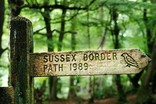
- Ignore ways off. In 250 metres you cross a path signposted Sussex Border Path / Serpents Trail, with wooden gates on your left, and you carry straight on , slightly uphill, still in woodland, your direction 160°. Soon you have a small ditch and an earthbank on your left‑hand side. 275 metres further on, you temporarily emerge from the woodland as the path veers to the right and then, in 70 metres, at a cross-paths [!] turn left , your direction 140° in the direction of the footpath sign (You can further identify this crossing by the houses just visible 100 metres away to your left, at 120°, houses which become very visible 40 metres further on.)
- [6] In 80 metres from this crossing, you go through a wooden swing gate to reach a tarmac road that leads (off to the left) to a small housing estate.
- But you cross straight over this tarmac road and carry on, gently downhill into light woodland, your direction due south.
- In 60 metres, you come to a footpath post with direction pointing ahead, but instead, [!] you turn right down a footpath, your direction 240°, and in another 70 metres, you turn left on a public road near a National Trust sign for Marley Common (sign missing January 2020). Ahead of you at this point there is a fine view.
- Go along this road for 200 metres then [7], just before the road heads downhill quite steeply, fork right (initially due south), back into woodland, on to an earth road that is signposted with a restricted byway sign.
- Follow this undulating earth road for 550 metres as it bends in and out, roughly parallel to the minor power lines on your left‑hand side, until - having exited the woodland - you come to a fork in the road, with a wooden fieldgate up to your right‑hand side, and by a three-way bridleway and restricted byway sign. Ignore the surfaced access road ahead but instead take the left fork, still on an earth road , your direction 160°. [8] After 150 metres you come to houses on the left (one of the houses is The Old Orchard) and you carry straight on along a narrower signposted path, initially due south and steeply downwards, initially in a cutting then out in the open along the hillside.
- Stick to this footpath as it zigzags downhill for 160 metres to meet a tarmac road. Cross this and carry on down the signposted footpath in woodland, your direction 170°.
- In 200 metres, you ignore a turn off footpath signposted to your left and keep walking downhill, parallel to the minor power line on your left hand side, and then, in 90 metres, by a three-way footpath and restricted byway sign, at a path junction, keep left and downwards on the main fork, your direction 150° (going under the power line) rather than straight on (slightly right) towards a stile and metal fieldgate.
- In 70 metres [9], you come out on to a tarmac lane by Updown Cottage. Continue down this lane, your direction due south, and in 400 metres, you come to a house (Thrae) and garden on your left hand side.
- 80 metres beyond Thrae, the lane swings to the right and you take the footpath to the left that is some 20 metres beyong a three-armed footpath sign, to cross over a green open space with oak trees, your initial direction 160°.
- In 60 metres, by a footpath post, you enter woods and head down a flight of earthen, shuttered steps to cross a stream on 3-plank wooden bridge with wooden handrail, then up the other side on more earthen, shuttered steps. At the top, bear left along an earth path, steadily uphill, with gardens on your right-hand side behind a series of high close boarded fences).
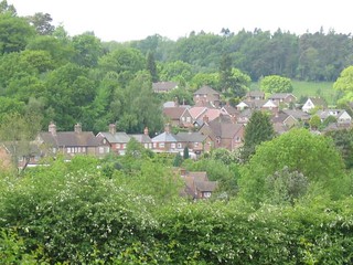
- In 225 metres the path becomes tarmac. Keep ahead for a further 310 metres to come out onto the main road, the A286. Cross straight over and head down Hogs Hill, keeping to this tarmac road for 400 metres down to the Red Lion pub [10], the suggested lunchtime stop. Just beyond the pub is Fernhurst Recreation Ground, an ideal spot for picnickers. Within the recreation ground is The Fern (Cafe) in the Pavilion, your alternative lunch option on this walk.
- After lunch the route is relatively gently uphill for the first 2.5km, on bridleways that can be very muddy. You can take respite from the worst of the mud in two ways: by walking along the top of the banks on either side of bridleways when in shallow cuttings, or - for those wearing good leather boots - by walking up the streams, usually coming down the middle of muddy paths after periods of heavy rain.
- Turn left out of the pub and left again alongside the pub and its back garden, following the footpath sign's direction, your direction 80°, in 20 metres passing Manesty Cottage on your right-hand side, and in a further 40 metres entering woods.
- Keep to the main path. In 130 metres, you cross a stream and in a further 30 metres you ignore a fork off to the right. In a further 110 metres, ignore two fieldgates off to your left (one metal, one wooden).
- In 80 metres the path swings to the left by a two-armed footpath sign. In a further 130 metres the path bends to the right to cross a stream where the water falls down from a storm pipe, with the stream soon on your left hand side.
- In 170 metres [11], at the next T-junction, with a wooden barn opposite, turn left , following the footpath sign, up a car-wide earth track, your direction 30°.
- In 70 metres, at a fork in the path, by a three-way footpath signpost, take the right-hand fork (almost straight ahead), steadily uphill, your direction 70°. You will be following the overhead electricity cable for some way. This path can be very muddy - you might be able to take respite from the mud by walking along the top of the low banks on either side of the path.
- After 100 metres, ignore a fork to the left.
- In 220 metres at the next crossing, again follow the footpath sign straight on, initially 40°.
- Again, if it is very muddy at this point, you can normally scramble along the top of the banks to the left or right of the path.
- In 200 metres at the next crosspaths, keep ahead (slightly right) to follow the footpath sign straight on and up (alongside the electricity cable), the only signed footpath on offer, your direction 80°. Soon you are sharing the steep path uphill with a tiny stream coming down to it.
- After 125 metres take the right fork at a path junction and keep ahead, still uphill, still muddy, in 200 metres coming up to a tarmac lane with a farmhouse on your right hand side.
- Here you have a choice, the main route, or a recommended option to visit the Temple of the Winds, a sheltered viewpoint with stone seats.
- The Temple of the Winds Option
- Turn right on a car wide track, soon with views to the south. It bends to the north and joins a road. Turn right.
- In 50m take a signed footpath to the left, and in 25m take the left hand fork. Follow this path uphill (60°). Keep going for 500m, reaching the top of the hill, and entering National Trust land.
- Continue, through trees, along the top of the plateau. Eventually, a short path down to the right leads to the Temple at the south east corner of the hill.
- To rejoin the main route, leave the Temple and take the 330° path (the left of the 2 main paths), soon with view to your left. Follow this winding path on the plateau in a northerly direction for 800 metres to reach a five-way path junction; this is [13] below.
- The Main Route
- Leave the overhead electricity cable to take a sharp left following the signed bridleway up to your left, gently uphill through light woodland, your direction 330°.
- 150 metres from the farmhouse, at a bridleway path junction, ignore a left turn to continue straight ahead, now more steeply uphill, and soon in a cutting.
- After 200 metres go straight through a fieldgate entrance (it has a 3 arm bridleway signpost on the right hand side) and down for 80 metres to a tarmac road. 10°.
- Turn left on the tarmac road , with the Royal Stables, an Arab stud farm, immediately on your right-hand side (there is a sign in Arabic at the entrance). Just past the farm, turn right on a tarmac road, signposted as a bridleway, your initial direction 20°.
- Go on up to reach Cotchet Farm after 270 metres [12]. Here there is a National Trust sign for Black Down on your right hand side.(if you change your mind about visiting Black Down, take the path here).
- Otherwise, continue ahead, keeping the farm buildings on your left hand side. In 70 metres go through a wooden gate, and at the three armed signpost fork right to follow the bridleway sharply uphill, in a woodland strip, your direction 20°.
- Follow this bridleway, which is somewhat winding, and ignore ways off and smaller paths to your left. Continue in a generally north-easterly direction, and in 300 metres, having left the light woodland strip, a path joins from the right. You are now in glorious open space with heather and gorse on both sides. You also now have wonderful views over to your left. In a further 500 metres, with the path having levelled out and descended a little), you come to a major five-way path junction.
- [13] Both routes continue
- At this path junction there is a small triangular grassy green, with at its apex a rectangular sign pointing right "To Tennyson's Lane car park". [The alternate ending, see below, starts here].[!] Here you turn sharp left on to the signposted Sussex Border Path/Serpents Trail (SBP/ST) bridleway, a car wide sandy track, your direction west, initally over open space with heather and gorse on both sides (pine trees and rhododendrons come later).
- From here on, follow the SBP/ST signs for 2km almost all the way to Valewood House down in the valley. But in more detail: In 220 metres ignore a right fork.
- In 500 metres at a cross-paths, go through a wooden gate to carry straight on, your direction 320°. In 70 metres at the next junction take the SBP/ST to the left, your direction 280° (alternatively, you can continue ahead here, rejoining the Book route at the next wooden gate). Go downhill, and after 200 metres near the bottom of the hill, at the T-junction, the bridleway goes left (downhill) through a gate but you take the SBP/ST right, initially 20°.
- In 350 metres, the path veers left. Ignoring a turn off to the right, go through a wooden gate to go down a footpath through what becomes in the month of May almost a tunnel of over-arching rhododendrons. In 320 metres you go through a wooden gate to enter Valewood Park (marked by a National Trust sign), to veer right on the signposted SBP/ST down across a large open, grassy field (initially 310°), in the direction of a large mansion house on the opposite hill).
- In 370 metres at the lower right hand corner of the field, go through a pair of wooden gates and you can see down to Valewood Farmhouse below.
- The Sussex Border Path continues straight on down the right-hand edge of the field ahead, but the suggested route (a short cut) is to take the bridleway car wide track off to the left, steeply downhill, its direction 280°.
- At the T-junction at the bottom of the field, go left, again signposted SBP/ST, through another pair of wooden gates, and down 70 metres, keeping right, to turn right along an (initially) car-wide tarmac track, your direction north, [14] to carry on past Valewood Farmhouse on your right hand side in 120 metres. In 160 metres go through Valewood Farmhouse's entrance gate to cross a stream and turn right up a car-wide shingle track, passing Stedlands Farm on your left.
- In 70 metres go past the entrance drive on your right that leads to The Stables, a large new brick house with diamond-paned windows. In 10 metres, at a fork in the track marked with a footpath sign, take the bridleway uphill to the left, your direction 20°. Then go fairly steeply uphill, ignoring turn-offs,in a cutting through a woodland strip. In 500 metres, you come to a tarmac road at the top with a house called Littlecote on your left hand side, and on your right Oakhurst which was rebuilt in 2020. Turn left and, in 20 metres turn right along a tarmac path marked 'Neighbourhood Watch Area’, with an anti-motorbike metal barrier at its start, the direction 20°, and soon with playing fields on your left hand side.
- In 350 metres, cross a minor tarmac road and keep straight on, down a path with steps between high hedges, to the main road, the B2131 [15]. Here turn left and head straight on to Haslemere Town Hall in 200 metres, and then turn right into the High Street. In 40 metres, you pass the White Horse Hotel on your right hand side. 100 metres beyond this, you come on your left hand side to one of the suggested tea places, Darnleys tearoom, a long-time favourite of SWC walkers. Directly opposite Darnleys and an excellent alternative tea stop - and serving delicious cakes - is Hemmingways . Nearby, on West Street, on your way to the railway station, was the Real English Drinks House (but permanently closed per the website).
- Coming out of Darnleys tearoom, turn right and in 25 metres, turn right again down West Street, signposted to the police station. In 120 metres, where the main street curves to the right past the police station (which is on your right hand side), take the street straight on to the fire station but then not the tempting path straight on; instead, turn left in front of the fire station along a tarmac lane and in about 50 metres turn right along a narrow tarmac path to continue to the left of the fire station, your direction 315°. Now follow this path, with a stream to your right and later a playground to your left, till you come out on to a tarmac road with Redwood Manor opposite. Turn left on this road and, in 40 metres, turn right on to the B2131, leading in 260 metres to Haslemere Railway Station on your right hand side. Metro Café is on your right just before the station and Inn on the Hill, with its bar, is opposite the station.
- The London platforms (2 and 3) are over the footbridge.
Possible Alternate Ending
We are investigating a more rural alternate ending from the top of Black Down, staying high for longer, on some National Trust paths (which aren't on the OS maps, but are on the NT maps of the area)
Use an OS map! Note the warning about 20m along a dangerous road
- At the 5 way junction, at the top of Black Down, head north on a level main path to the NT car parks.
- Fork left (on the Pen Y Bos track, not waymarked, but on OS maps).
- Fork left again to join a path thats just south of (but parallel to) the minor road that lead to Haslemere.
- At the end of the NT land, the lane joins the minor road (Tennyson's Lane) and continue west. Take a footpath down to your right.
- Head vaguely north/north west down to the A road. Turn left for Haslemere High Street. Note there is a dangerous 20m section of fast A road with no pavement