Billingshurst to Amberley Walk
Starts in gentle countryside, with the South Downs a thin line on the horizon, then via some steep hills and hidden valleys to finish on the crest of the South Downs with a panoramic view


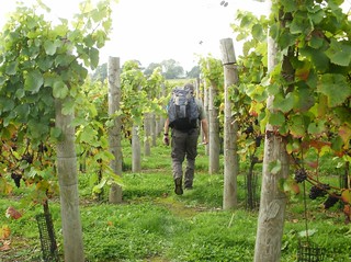
Through the vineyard
OLYMPUS DIGITAL CAMERA
Mar-01 • lindsay_randle on Flickr
book3 swcwalks swcwalk8 21910011910

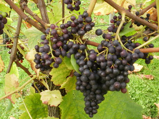
Vineyard
OLYMPUS DIGITAL CAMERA
Mar-01 • lindsay_randle on Flickr
book3 swcwalks swcwalk8 22071974956


| Length |
22.8km (14.2 miles) |
|---|---|
| Toughness |
5 out of 10 – fairly flat, but with a stiff hill climb at the end. |
| Maps |
OS Explorer OL10 (formerly 121) and OL34 (formerly 134) OS Landranger 197 (a tiny bit near the start on 198) |
| Features |
This walk is an illustration of the maxim that a pleasure deferred is a pleasure intensified. It starts in very gentle countryside, from where there are occasional glimpses of the South Downs as a thin line in the distance. Gradually throughout the day, you get closer and closer to them, and finally there is an exhilarating finish along their crest, with panoramic views of the Arun valley. But way before you get to them, just before lunch, there is a surprise area of High Weald-like territory of steep hills and hidden valleys. Early in the walk, there is a particularly fine bluebell and wood anemone wood, making this a good excursion for late April or early May. The length of the afternoon section - 13.5 km (8.4 miles) means this walk is not viable from November to February. |
| Walk options |
This walk has a sister walk – Pulborough to Amberley - which shares the same lunch stop and a small centre section, and has the same finish over the Downs to Amberley. It is thus possible to do the morning of one and the afternoon of the other. The morning of the Pulborough to Amberley walk is 5.5km (3.4 miles) versus 9.3km (5.8 miles) for this walk, and its afternoon is 11.2km (6.9 miles) compared to 13.5km (8.4 miles) for this walk. |
| Transport |
Billingshurst and Amberley are both on the Horsham-Littlehampton line, served by trains out of Victoria. Catch the nearest train to 9.20am from Victoria to get to lunch in time. Buy a day return to Amberley. |
| Lunch |
Rising Sun, Nutbourne (01798 812191) 9.3 km (5.8 miles) into the walk. Described in one comment as “just how a village pub should be”, it is a very atmospheric place, with a cosy interior and a pleasant garden. It offers a varied menu with good walker-sized portions from 12pm to 2pm (3pm on Sundays). It is open an hour later than these times for drinks. A possible picnic spot is mentioned in paragraph 42 of the directions, although this is only 7.3km (4.6 miles) into the walk |
| Tea |
The Crown Inn (01903 742625) Cootham, 15.6km (9.7 miles) into the walk, is a possible early tea stop at weekends in spring and summer, when the proprietor says he “usually stays open all afternoon”: an ideal choice to refresh yourself before climbing on the Downs. The two tea rooms at the end of the walk unfortunately close rather early. The Riverside Tea Rooms at Houghton Bridge (near Amberley Station) close at 4.30pm daily, while the charming Amberley Village Tea Room (on the longer river ending, but also accessible from the main walk route with a small diversion) now closes at 4pm Thursday to Tuesday (ie closed Wednesday) Fortunately there is a very friendly and atmospheric pub by Amberley Station, the Bridge Inn (01798 831 619). It serves tea and coffee until at least 10.30pm, and meals from 6pm, and has a very pleasant garden. For a picnic tea, the fine viewpoint mentioned in paragraph 110 of the directions is ideal. |
| Profile | |
|---|---|
| Help Us! |
After the walk, please leave a comment, it really helps. Thanks! You can also upload photos to the SWC Group on Flickr (upload your photos) and videos to Youtube. This walk's tags are: |
| By Train |
Out (not a train station) Back (not a train station) |
| By Car |
Start Map Directions Return to the start: Finish Map Directions Travel to the start: |
| Amazon | |
| Help |
National Rail: 03457 48 49 50 • Traveline (bus times): 0871 200 22 33 (12p/min) • TFL (London) : 0343 222 1234 |
| Version |
Sep-24 Peter |
| Copyright | © Saturday Walkers Club. All Rights Reserved. No commercial use. No copying. No derivatives. Free with attribution for one time non-commercial use only. www.walkingclub.org.uk/site/license.shtml |
Walk Directions
Full directions for this walk are in a PDF file (link above) which you can print, or download on to a Kindle, tablet, or smartphone.
This is just the introduction. This walk's detailed directions are in a PDF available from wwww.walkingclub.org.uk


