Bruton Circular via Stourhead Walk
Through quiet South Somerset pastures and across a wooded ridge past Alfred's Tower folly and through the beautifully landscaped Stourhead Estate

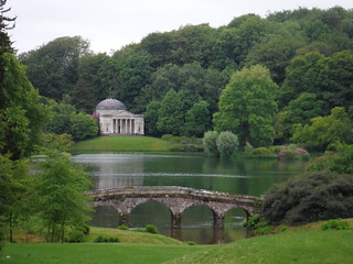
Palladian Bridge and Pantheon across Garden Lake, Stourton (Stourhead Estate)
SWC Walk 342 - Bruton Circular (via Stourhead)
Jun-19 • thomasgrabow on Flickr
swcwalks swcwalk342 banner 48079221888

Alfred's Tower, front view
SWC Walk 342 - Bruton Circular (via Stourhead)
Jun-19 • thomasgrabow on Flickr
swcwalks swcwalk342 walkicon 48079194531

The Iron Bridge, Stourhead Estate
SWC Walk 342 - Bruton Circular (via Stourhead)
Jun-19 • thomasgrabow on Flickr
swcwalks swcwalk342 walkicon 48079224673

Bristol Cross, Palladian Bridge and Pantheon across Garden Lake, Stourton (Stourhead Estate)
SWC Walk 342 - Bruton Circular (via Stourhead)
Jun-19 • thomasgrabow on Flickr
swcwalks swcwalk342 walkicon 48079291907

Stourhead House, Stourton
SWC Walk 342 - Bruton Circular (via Stourhead)
Jun-19 • thomasgrabow on Flickr
swcwalks swcwalk342 walkicon 48079290137
| Length |
22.7 km (14.1 mi), with 490m ascent/descent. For a longer walk see below Walk Options. |
|---|---|
| Toughness |
6 out of 10, with 5 ½ hours walking time. For the whole outing, including trains, sights and meals, allow at least 11 hours. |
| Walk Notes |
This excursion is centred on the small remote Somerset town of Bruton, with its honey-coloured stone-built cottages, a large dovecote on a mound overlooking the townscape and a fine selection of tea options. It leads along the vigorous River Brue and through bucolic pastures up to the wooded range forming the boundary between Wiltshire and Somerset, with the dominant local landmark Alfred’s Tower, a folly, on top of it. From there you drop down through enchanting woods to the heart of the Stourhead Estate at the source of the River Stour, with its breath-taking 18th century landscaped garden with lakeside walks, grottoes and classical temples (National Trust, ticketed entry, although large parts of the garden and most notable buildings are visible from the walk route).
A start from Castle Cary (with faster and more frequent trains) adds about an hour of walking. |
| Walk Options |
An out-and-back to the Bronze Age Bell Barrow site Jack’s Castle adds 550m.
|
| Maps |
OS Explorer: 142 (Shepton Mallet & Mendip Hills East)
|
| Travel |
Bruton Station, map reference ST 687 347, is 45 km west of Salisbury, 31 km south of Bath and 168 km south west of Charing Cross. It lies 72m above sea level and in South Somerset. Bruton Station is a stop on the Heart of Wessex line from Bristol to Weymouth. There is also a limited direct service from/to London Waterloo. For the fastest connection from London a change is therefore usually necessary, either in Bath Spa, Westbury or Castle Cary, journey time from 112 minutes. Saturday Walkers’ Club: Bruton is outside the Network Southeast Railcard zone. Off-Peak returns for morning departures can be expensive. Advance tickets are usually the better option. |
| Elenvenses/Lunch |
The Old Red Lion North Brewham, Bruton, Somerset, BA10 0JL (01749 850 287). The Old Red Lion is located 950m off route, 5.0 km/3.1 mi into the walk.
|
| Tea (on or just off route) |
The Bull Inn Hardway, Kingsettle Hill, Bruton, Somerset, BA10 0LN (01749 812 200). The Bull Inn is owned by Hauser & Wirth and managed by the team behind the Roth Bar & Grill. It is located 1.0 km off route, 4.5 km from the end of the walk. This pub is currently closed.
|
| Tea (on a loop through town) |
The Bruton Castle 45 High Street, Bruton, Somerset, BA10 0AW (01749 812 104). This pub is currently closed.
|
| Stay |
Accomodation at Stourhead:
For details check: https://www.nationaltrust.org.uk/stourhead/features/stay-with-us-at-stourhead |
| Profile | |
|---|---|
| Help Us! |
After the walk, please leave a comment, it really helps. Thanks! You can also upload photos to the SWC Group on Flickr (upload your photos) and videos to Youtube. This walk's tags are: |
| By Train |
Out (not a train station) Back (not a train station) |
| By Car |
Start Map Directions |
| Amazon | |
| Help |
National Rail: 03457 48 49 50 • Traveline (bus times): 0871 200 22 33 (12p/min) • TFL (London) : 0343 222 1234 |
| Version |
Jul-22 Thomas G |
| Copyright | © Saturday Walkers Club. All Rights Reserved. No commercial use. No copying. No derivatives. Free with attribution for one time non-commercial use only. www.walkingclub.org.uk/site/license.shtml |
Walk Directions
Full directions for this walk are in a PDF file (link above) which you can print, or download on to a Kindle, tablet, or smartphone.
This is just the introduction. This walk's detailed directions are in a PDF available from wwww.walkingclub.org.uk
