Dorchester Circular or to Portesham Walk
Pre-historic landscape of the Dorset Downs with splendid views out to the Jurassic Coast from the South Dorset Ridgeway. Longer extension to the Valley of (Sarsen) Stones

Hardy Monument and Memorial Bench
SWC Walk 275 Dorchester South Circular or to Portesham
Aug-16 • thomasgrabow on Flickr
swcwalks swcwalk275 banner walkicon 28822586313

Maiden Castle Iron Age Hillfort, in the evening sun
SWC Walk 275 Dorchester South Circular or to Portesham
Aug-16 • thomasgrabow on Flickr
swcwalks swcwalk275 walkicon 29444964825

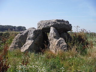
Hell Stone Burial Chamber
SWC Walk 275 Dorchester South Circular or to Portesham (Extension)
Aug-16 • thomasgrabow on Flickr
swcwalks swcwalk275 walkicon 29156585290

Barrows and Sheep on Bronkham Hill
SWC Walk 275 Dorchester South Circular or to Portesham
Aug-16 • thomasgrabow on Flickr
swcwalks swcwalk275 walkicon 28820285394

Clandon Barrow from Grove Hill Bottom
SWC Walk 275 Dorchester South Circular or to Portesham
Aug-16 • thomasgrabow on Flickr
swcwalks swcwalk275 walkicon 28822448683
| Length | 24.3 km (15.1 mi), with 423m ascent/descent. For a longer walk and an Alternative Ending, enabling shorter versions, see below Walk Options. |
|---|---|
| Toughness | 6 out of 10, with 5 ¾ hours walking time. For the whole outing, including trains, sights and meals, allow at least 12 hours. |
| Walk Notes |
Rewarding expedition from the county town of Dorset through the pre-historic landscape of the Dorset Downs with splendid views out to the Jurassic Coast from the South Dorset Ridgeway.
Maumbury Rings, an ancient British henge earthwork converted by the Romans for use as an amphitheatre (the largest of its kind in Britain), is walked through early on. Then Maiden Castle, the largest – and one of the most complex – Iron Age hill fort in Europe, with its up to four banks and three ditches and remains of a Romano-Celtic temple, is explored in detail. Settled from 4000 BC, it was one of the most powerful settlements in pre-Roman Britain, the Durotriges were the last tribe to have lived there. From there the route follows the narrow South Winterbourne Valley to lunch in Martinstown before a long ascent up to the heathery Black Down, crowned by the 22m-high Hardy Monument (to Sir Thomas Hardy the Admiral, not the writer), with some stunning views to the Jurassic Coast and the Isle of Portland. Continue with views out to sea atop Bronkham Hill, with an interesting group of barrows and shakeholes on its ridge. On the descent from it you pass more barrows, en route back to Dorchester. A long extension adds more pre-historic highlights – the Valley of (Sarsen) Stones, one of the finest examples of a boulder ‘train’ in Britain, several impressive barrows and two stone circles – and leads through the very pretty Bride Valley. |
| Walk Options |
You can omit parts - or all - of the loop through Maiden Castle: cut up to 2.3 km and 75m ascent.
You can omit the final ascent to the Hardy Monument: cut 1.1 km and 50m ascent. You can add a ‘pre-historic’ loop from the Hardy Monument via the Valley of Stones, Littlebredy and various Stone Circles and Barrows, adding up to 13.1 km (8.2 mi) and 477m ascent/descent to the walk (10/10). This includes 1.0 km of optional out-and-backs to Bridehead Lake & Waterfall and to a couple of Barrows, as well as an option to cut out 1.1 km distance and 78m ascent between the Valley of Stones and Littlebredy. The resulting very long walk should take about 9 hours net to complete. An Alternative Ending at Portesham (then bus to Weymouth) enables two more variations:
|
| Maps | OS Explorer: OL15 (Purbeck & South Dorset)
|
| Travel | Dorchester (South) Station is on the London Waterloo to Weymouth Main Line, with two trains per hour Mondays-Saturdays (journey time from 149 mins) and an hourly service on Sundays (journey time 168 mins). Portesham (opp. Kings Arms) is a stop on line X53 (Axminster – Weymouth King’s Statue [a 5 mins walk to the station]), with a roughly two-hourly service (last bus around 19.00 Mon-Sat, and 18.03 Sun). Buy a Dorchester South return ticket – or a Weymouth return for the Portesham Ending.
Saturday Walkers’ Club: Take a train no later than 8.45 hours. |
| Lunch |
The Brewer’s Arms Martinstown, Dorchester,Dorset, DT2 9LB (01305 889 361). The Brewer’s Arms is located 8.7 km (5.4 mi) into the walk. It is a pub with rooms with a large courtyard garden. |
| Tea |
Tea (Dorchester Ending):
Tea (Portesham/Bus to Weymouth Ending):
|
| Profile | |
|---|---|
| Help Us! |
After the walk, please leave a comment, it really helps. Thanks! You can also upload photos to the SWC Group on Flickr (upload your photos) and videos to Youtube. This walk's tags are: |
| By Train |
Out (not a train station) Back (not a train station) |
| By Car |
Start Map Directions |
| Amazon | |
| Help |
National Rail: 03457 48 49 50 • Traveline (bus times): 0871 200 22 33 (12p/min) • TFL (London) : 0343 222 1234 |
| Version |
Jul-23 Thomas G |
| Copyright | © Saturday Walkers Club. All Rights Reserved. No commercial use. No copying. No derivatives. Free with attribution for one time non-commercial use only. www.walkingclub.org.uk/site/license.shtml |
Walk Directions
Full directions for this walk are in a PDF file (link above) which you can print, or download on to a Kindle, tablet, or smartphone.
This is just the introduction. This walk's detailed directions are in a PDF available from wwww.walkingclub.org.uk


