Dovedale (Ashbourne Circular) Walk
Through a pastoral landscape to the Peak District's most famous and scenic dale with its ravines, crags, pinnacles, arches and caves
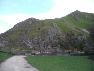
Thorpe Cloud and Bend in River by the Stepping Stones
SWC Walk 326 - Dovedale (Ashbourne Circular)
Apr-19 • thomasgrabow on Flickr
swcwalks swcwalk326 banner 32768278747
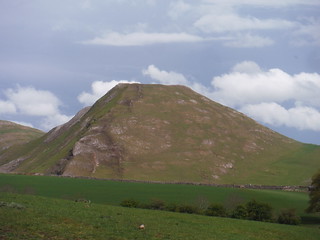
Thorpe Cloud from field above Izaak Walton Hotel
SWC Walk 326 - Dovedale (Ashbourne Circular)
Apr-19 • thomasgrabow on Flickr
swcwalks swcwalk326 walkicon 40745249163
![View back down Hall Dale SWC Walk 326 - Dovedale (Ashbourne Circular) [Long Version via Alstonefield]](https://live.staticflickr.com/65535/46795530385_9517bb5166_n.jpg)
View back down Hall Dale
SWC Walk 326 - Dovedale (Ashbourne Circular) [Long Version via Alstonefield]
Apr-19 • thomasgrabow on Flickr
swcwalks swcwalk326 walkicon 46795530385
![Viator's Bridge, Milldale SWC Walk 326 - Dovedale (Ashbourne Circular) [Long Version via Alstonefield]](https://live.staticflickr.com/65535/32768287867_f9e66765c1_n.jpg)
Viator's Bridge, Milldale
SWC Walk 326 - Dovedale (Ashbourne Circular) [Long Version via Alstonefield]
Apr-19 • thomasgrabow on Flickr
swcwalks swcwalk326 walkicon 32768287867
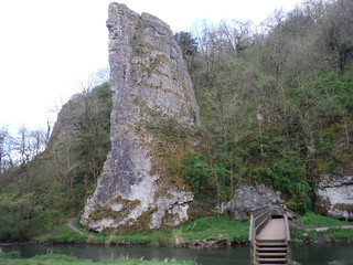
Ilam Rock and Footbridge, Dovedale
SWC Walk 326 - Dovedale (Ashbourne Circular)
Apr-19 • thomasgrabow on Flickr
swcwalks swcwalk326 walkicon 40745241413
| Length |
20.0 km (12.4 mi), with 543m ascent/descent. For a longer or shorter walk see below Walk Options. |
|---|---|
| Toughness |
6 out of 10, with 5 hours walking time. For the whole outing, including trains, sights and meals, allow at least 12 hours. |
| Walk Notes |
A walk from Ashbourne, a pretty market town near the Staffordshire/Derbyshire border where the Midlands’ plains meet highland Britain, through the White Peak area and the Peak’s most scenic and famous dale. You follow a dismantled railway line out of town and then a whaleback-shaped ridge north through a lovely pastoral landscape to Thorpe, where the isolated reef limestone hills of Thorpe Cloud and Bunster Hill guard the southerly end of Dovedale. The route initially skirts to the west of the dale around Bunster Hill to avoid the early day crowds in the dale and later climbs up the hill to stay high above the dale on an airy route before dropping down into it through woods. The core part of Dovedale, with its numerous impressive limestone ravines and cliffs, towering crags and pinnacles, arches and caves, is then walked downstream – flanked by some of the best calcareous ash woods in England – to the most iconic part of Dovedale: the picturesque Stepping Stones. A final ascent through the scenic Lin Dale with fantastic back views is followed by a long stretch back to Ashbourne along the dismantled railway line.
A short walk gets you straight to the Stepping Stones and you can add an easy out-and-back up Dovedale.
|
| Walk Options |
A Short Walk to the base of Thorpe Cloud and then along the River Dove to the Stepping Stones and the bottom of Dovedale proper is 13.8 km/8.6 mi long with 213m ascent (rated 2/10). This can/should be combined with an (flat bar one small ascent) out-and-back up Dovedale towards Milldale hamlet with its tea option of a length of your choosing (up to 4.2 km/2.6 mi each way).
|
| Maps |
OS Explorer: 259 (Derby) & OL24 (The Peak District – White Peak Area)
|
| Travel |
Ashbourne bus station, map reference SK 180 465, is 20 km north west of Derby, 200 km north west of Charing Cross, 118m above sea level and in Derbyshire. It is served by buses from all corners of the Peak District and surrounding areas, most useful are those from Derby: Line 114 Derby - Ashbourne from/to Derby Train Station (Mon-Sat, 54 mins) and Swift Derby – Mayfield – Uttoxeter from/to Derby Bus Station (half-hourly, but hourly on Sun, 37 mins journey time). A 1.1 km walk in Derby from train station to bus station is needed for the Swift bus and is described at the start of the directions and also shown on the route map. Derby Station is on the Midland Main Line from London St. Pancras, with two trains per hour Monday to Saturday, one per hour Sundays (journey time from 85 mins Monday-Saturday, much longer on Sundays). Saturday Walkers’ Club: Take a train no later than 8.30 hours. |
| Elevenses/Lunch |
The Dovedale Bar at the Izaak Walton Hotel Ilam, Dovedale, Ashbourne, Staffordshire, DE6 2AY (01335 350 981). The Izaak Walton is located 7.1 km/4.4 mi into the walk.
|
| Lunch/Tea |
En route:
In Ashbourne, on an optional route through town:
Fenny Bentley Ending:
Near Derby Bus Station:
Near Derby Train Station:
|
| Profile | |
|---|---|
| Help Us! |
After the walk, please leave a comment, it really helps. Thanks! You can also upload photos to the SWC Group on Flickr (upload your photos) and videos to Youtube. This walk's tags are: |
| By Car |
Start Map Directions |
| Amazon | |
| Help |
National Rail: 03457 48 49 50 • Traveline (bus times): 0871 200 22 33 (12p/min) • TFL (London) : 0343 222 1234 |
| Version |
Feb-25 Thomas G |
| Copyright | © Saturday Walkers Club. All Rights Reserved. No commercial use. No copying. No derivatives. Free with attribution for one time non-commercial use only. www.walkingclub.org.uk/site/license.shtml |


Walk Directions
Full directions for this walk are in a PDF file (link above) which you can print, or download on to a Kindle, tablet, or smartphone.
This is just the introduction. This walk's detailed directions are in a PDF available from wwww.walkingclub.org.uk