Hitchin Circular Walk
Across the most north easterly Chilterns ridge to Pegsdon Hills and Knocking Hoe NNR. A motte-and-double bailey and an abandoned medieval village and the Oughton chalk river

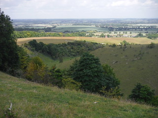
Pegsdon Hills
SWC Walk 234 Hitchin Circular
Jun-15 • thomasgrabow on Flickr
swcwalks swcwalk234 walkicon banner 19111465789

View from Hitchin Hill to Charlton
SWC Walk 234 Hitchin Circular
Jun-15 • thomasgrabow on Flickr
walkicon swcwalks swcwalk234 18676418234

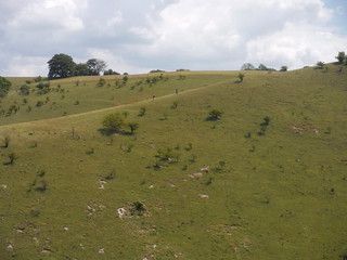
Two walkers on the alternative descent-route
SWC Walk 234 Hitchin Circular
Jun-15 • thomasgrabow on Flickr
walkicon swcwalks swcwalk234 19297484465

Hitchin Waterfall (the millstream overflow)
SWC Walk 234 Hitchin Circular
Jun-15 • thomasgrabow on Flickr
walkicon swcwalks swcwalk234 18674564464

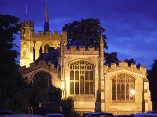
St. Mary's, Hitchin in dusk
SWC Walk 234 Hitchin Circular
Jun-15 • thomasgrabow on Flickr
walkicon swcwalks swcwalk234 19108672238
| Length | 25.6 km (16.0 mi), with 355m ascent/descent. For a shorter walk or an alternative finish see below Walk Options. |
|---|---|
| Toughness | 6 out of 10, with 6 hours walking time. For the whole outing, including trains, sights and meals, allow at least 8 ¼ hours. |
| Walk Notes | This Hertfordshire walk covers the hilly area west of Hitchin. The morning route leads along farm tracks, field boundaries, shaded grassy lanes and through a few woods across the most north easterly ridge of The Chilterns, in Great Offley, to the steep chalk downlands of Pegsdon Hills and Knocking Hoe, dissected by quiet flat bottomed valleys, which form the scenery around the lunch stop in Pegsdon, where the terraced pub garden provides stunning views overlooking the hills.
From Knocking Hoe National Nature Reserve, the ancient Icknield Way leads to the pretty village of Pirton, with its impressive remains of a motte-and-double bailey and traces of an abandoned medieval village. On the outskirts of Hitchin, Oughtonhead Common is a mature alder and willow fen woodland, whose diversity of habitats is surprisingly large. From there the route follows the high quality chalk river Oughton all the way to its wellhead. The final stretch leads past a very charming farm gate café to Hitchin’s old town, which has kept its medieval market town feel and has many fine Tudor and Georgian buildings. Pass St. Mary’s Church, the largest parish church in Hertfordshire and evidence of how Hitchin prospered from the wool trade, and brave a final steep ascent through a park to then re-trace part of the morning route back to the train station at the easterly end of town. This is a stile-free walk. |
| Walk Options | A shortcut around lunch reduces the length of the walk by 2.2 km and the ascent/descent by 56m.
A shortcut just before the end reduces the length of the walk by 2.5 km and the ascent/descent by 53m.
Taking any shortcut reduces the effort to 5/10, taking both makes it a 4/10.
An infrequent bus service gets you from Pirton (17.2 km into the main walk, and also the lunch stop if taking Shortcut I) straight to Hitchin, or to Henlow Camp, where you can connect to the more frequent service to Hitchin (Mon-Sat only). A short connection from the lunch stop in Pegsdon to Hexton means you can pick up SWC 229 (Leagrave to Harlington) there, and include the stunning Barton Hills in this walk. Harlington is on a different train line. |
| Maps | OS Explorer: 193 (Luton & Stevenage)
OS Landranger: 166 (Luton & Hertford) |
| Travel | Hitchin station, map reference TL 194 297, is 13 km north east of Luton and 7 km north west of Stevenage, 73m above sea level and in North Hertfordshire. It is on the East Coast Main Line and served by Thameslink services from London Bridge through St. Pancras (journey time 32 minutes from STP) and from King’s Cross (journey time 45 minutes Mon-Fri, from 32 minutes Sat-Sun).
Saturday Walkers’ Club: Take the train closest to 9.30 hours (assuming travel from St. Pancras). |
| Lunch | The Red Lion Kings Walden Road, Great Offley, Hitchin, Hertfordshire, SG5 3DZ (01462 768 281). The Red Lion is located 6.9 km (4.2 mi) into the walk.
The Green Man 5 High Street, Great Offley, Hitchin, Hertfordshire, SG5 3AR (01462 768 256). The Green Man is located 9.0 km (5.6 mi) into the walk. The View Pegsdon Way, Pegsdon, Bedfordshire, SG5 3JX (01582 882 555). The View is located 13.7 km (8.5 mi) into the walk. Restaurant and bar have stunning views overlooking Pegsdon Hills. The Motte & Bailey 1 Great Green, Pirton, Hitchin, Bedfordshire, SG5 3QD (01462 711 117). The Motte & Bailey is located 17.0 km (10.6 mi) into the main walk, 14.4 km if taking Shortcut I, and 8.7 km (5.4 mi) from the end of the main walk. It is a family-run pub with a pretty garden by the green. The Fox High Street, Pirton, Hitchin, Bedfordshire, SG5 3PS (01462 459 304). The Fox is located 17.4 km (10.9 mi) into the main walk, 14.8 km if taking Shortcut I and 8.4 km (5.2 mi) from the end of the main walk. Currently looking for a new tenant. |
| Tea | Plenty of options in Pirton, in Ickleford and at the Lavender Farm, and then in Letchworth. See the pdf for details. |
| Profile | |
|---|---|
| Help Us! |
After the walk, please leave a comment, it really helps. Thanks! You can also upload photos to the SWC Group on Flickr (upload your photos) and videos to Youtube. This walk's tags are: |
| By Train |
Out (not a train station) Back (not a train station) |
| By Car |
Start Map Directions |
| Amazon | |
| Help |
National Rail: 03457 48 49 50 • Traveline (bus times): 0871 200 22 33 (12p/min) • TFL (London) : 0343 222 1234 |
| Version |
Jan-25 Thomas G |
| Copyright | © Saturday Walkers Club. All Rights Reserved. No commercial use. No copying. No derivatives. Free with attribution for one time non-commercial use only. www.walkingclub.org.uk/site/license.shtml |
Walk Directions
Full directions for this walk are in a PDF file (link above) which you can print, or download on to a Kindle, tablet, or smartphone.
This is just the introduction. This walk's detailed directions are in a PDF available from wwww.walkingclub.org.uk
