Llanmadoc via Whiteford Sands Circular (Wales Coast Path) Walk
Out through NT pine forest with salt marsh views to a lighthouse, back along sand dunes and a remote beach.


| Length | Up to 11km / 7 miles |
|---|---|
| OS Map | OS Explorer 164 (Gower) |
| Toughness | 2 out of 10 |
| Features |
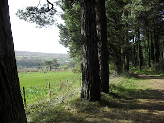
This is an unusual but stunningly beautiful walk. It starts in Llanmadoc, a small village on the north west corner of Gower, and heads into a NT Nature Reserve through a very pretty pine forest with salt marsh views on one side, and sand dunes on the other.. At the the end of the pine forest are lovely views over the sea / estuary to Pembrokeshire and the remains of a lighthouse (follow the tide out, don't stay long - dangerous tides!) Return along the long secluded sandy beach backed by sand dunes (or through the sand dunes). This area is discreetly used by naturists. Walking along the beach is easy going, even at high tide. Return through the pine forest along the base of a small hill, or walk a little further arouns the hill, and back over the headland. There is a gastro-pub in the village For a longer walk, climb Llanmadoc Hill, to the south of the village, for great views over Rhosilli bay, and over the sea towards Pembrokeshire. |
| Rhosilli | If you have a car, visit nearby Rhosilli - one of the most beautiful beaches in the country. |
| Travel | By car : SA3 1DJ. Small honesty car park, or park for free in the village. By bus: year round bus service from Swansea. |
| Stay | Rhosilli has B&Bs and Port Eynon a youth hostel. Mummbles (Oystermouth) is about 30 mins drive away if you have a car. Camping in Llangennith (reserve in advance weekends and summer) |
| Lunch and Tea |
|
| Gower Walks |
Clockwise from Swansea - Gower's beaches are exceptional - there really are this many 5 star walk here!
If you want to do the Gower Coast Path
| ||||||||||||||||
|---|---|---|---|---|---|---|---|---|---|---|---|---|---|---|---|---|---|
| Get There |
The nearest train station is Swansea, but its a 10 min walk to the bus station. Some early morning / late evening buses start from it though. London Paddington to Swansea : 2h 40m, £112 off peak return. 'Advance' tickets (no changes) are cheaper. A good compromise is "Advance" out, and an (Open) "Single" back - about £80. London Waterloo via Salibury and Bath : 5hr, £85 off peak return. Cheaper advance tickets. By coach: Flixbus, National Express coach By car: Driving to Swansea takes about 3 hours from London. The M4 Severn bridge is now free | ||||||||||||||||
| Buses |
You must check the bus times beforehand - using traveline.cymru/ Why? Because times and routes vary on school days, not school days, weekdays, Saturday, Sunday, summer, winter... There are 2 bus companies, each with a different system of tickets and day/week/group passes. It might be efficient, but its confounding for visitors! Partial update: Spring 2025 Since the previous update, almost everything has changed, operators, routes, fares, passes - this is why public transport is so hard to use Swansea bus station is about 15 mins walk from the train station. From there, 2 companies run buses to Gower, with a bizarre obfuscated schedule.
Current routes are ('bay' means on Swansea Bay)
Links
|
||||||||||||||||
| Stay |
Swansea is the best place for public transport users. The city doesn't have many tourist sites except for Wind Street (pronounced Wine Street, loads of mega pubs) and the marina. Many old seafront B&B's, and mega chain hotels. Mumbles (Oystermouth) is a pretty seaside village, quieter at night and more upmarket nowadays as the 'Mumbles mile' pubs are no more. Old B&Bs and boutieque hotels. Swansea's 'latin' quarter. There is a Youth Hostel in Port Eynon, and a large beach campsite on Rhossili beach near Llangennith. Also campsites at Three Cliffs. Rhossili itself would be a great place to stay for car travellers. | ||||||||||||||||
| Warning |
The Severn Estuary has the second highest tidal range in the world, with typically, a 30 foot (10 metre) vertical difference between high and low tide. If you walk along the beach beneath high cliffs, or far out on the sands, be aware that you can be cut off by a rising tide! | ||||||||||||||||
| Profile | |||||||||||||||||
| Help Us! |
After the walk, please leave a comment, it really helps. Thanks! You can also upload photos to the SWC Group on Flickr (upload your photos) and videos to Youtube. This walk's tags are: |
||||||||||||||||
| By Car |
Start Map Directions |
||||||||||||||||
| Map Walk | This walk requires an OS map and a compass or GPS for navigation. You can print out OS maps using the link above. | ||||||||||||||||
| Amazon | |||||||||||||||||
| Help |
National Rail: 03457 48 49 50 • Traveline (bus times): 0871 200 22 33 (12p/min) • TFL (London) : 0343 222 1234 |
||||||||||||||||
| Version |
Aug-24 Andrew |
||||||||||||||||
| Copyright | © Saturday Walkers Club. All Rights Reserved. No commercial use. No copying. No derivatives. Free with attribution for one time non-commercial use only. www.walkingclub.org.uk/site/license.shtml |


Walk Directions
- Walk through the village, past the pub, veer right at the junction, and pass the honesty car-park in a field on your right.
- Just before the entrance to the NT Nature Reserve, there is a footpath on your right ('Cwm Ivy and Betty Church Nature Reserve'), which make a nice change if you have done this walk before. It goes out on a dyke over the salt marsh. Turn left at the end to meet up with the main route in the pine forest. Note there isn't a church - Betty Church is the name of the person who donated some land to a Wildlife Trust
- Continue down the lane (below Cwm Ivy tor on OS maps), through the gate into the Whiteford Sands National Trust (NT) Nature Reserve. Continue downhill.
- Follow the paved path through the pine forest behind the beach (Whiteford Burrows). The 'salt marsh walk' path joins on your right.
- Follow the path (or sand dunes) to the end. Continue to Whiteford Point - the end of the "spit" - Take great care if going out as far as the lighthouse
- Return along the beach - Whiteford Sands - until you have reached the start of the cliff / small headland.
- The shortest way back is to walk inland, around the base of the small hill, to rejoin the path through the pine forest. Turn right, uphill to return to the village.
- Walk around the base of the cliff to the next beach, then inland, and up over the headland, keeping to the coast path. Eventually you reach the village road near the NT 'gate'