Malvern Hills from Great Malvern or Colwall Walk
Route over the iconic Malverns Range, rising out of the Plain, with optional routes covering all but a few of the tops.

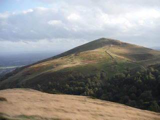
Worcestershire Beacon, from North Hill
SWC Walk 324 The Malvern Hills (Great Malvern Circular or from Colwall) - Northerly Extension
Sep-18 • thomasgrabow on Flickr
banner swcwalks swcwalk324 30585279817

British Camp/Herefordshire Beacon and Millenium Hill, from Pinnacle Hill
SWC Walk 324 The Malvern Hills (Great Malvern Circular or from Colwall)
Jul-22 • thomasgrabow on Flickr
banner swcwalks swcwalk324 52254284991

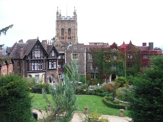
Priory Church and Abbey Hotel, Great Malvern
SWC Walk 324 The Malvern Hills (Great Malvern Circular or from Colwall)
Sep-18 • thomasgrabow on Flickr
walkicon swcwalks swcwalk324 45526343021

The Holy Well, the original source of Malvern Water
SWC Walk 324 The Malvern Hills (Great Malvern Circular or from Colwall)
Sep-18 • thomasgrabow on Flickr
walkicon swcwalks swcwalk324 44612525445

Black Hill (north), Pinnacle Hill (2 tops)
SWC Walk 324 The Malvern Hills (Great Malvern Circular or from Colwall)
Sep-18 • thomasgrabow on Flickr
walkicon swcwalks swcwalk324 44800914834
| Length |
20.6 km (12.8 mi) or 18.8 km (11.7 mi), with 1078m or 820/865m ascent/descent. For a shorter or longer walk see below Walk Options. |
|---|---|
| Toughness |
8 out of 10 or 7 out of 10, with 6 hours 15 minutes or 5 hours 30 minutes walking time. For the whole outing, including trains, sights and meals, allow at least 12 hours or 11 ½ hours. |
| Walk Notes |
The Malvern Hills stand majestically above the Severn Plain in Worcestershire and the rolling wooded hills of Herefordshire, offering far reaching panoramic views across a variety of landscapes from a multitude of viewpoints. The area is famed for its steep dramatic hills rising out of flat vales and for the pure spring water that flows from them, but it also offers a rich cultural heritage of forts, castles and priories in a landscape of ancient woodland, rolling pastures and wild, open commons.
There are several walk options, and all in they cover all but four of the 22 notable hilltops in the range. The completist starts from Colwall and includes the two extensions, starting out along fields and through oak woods at the westerly base of the hills to then return north to Malvern along the top of the ridge. |
| Walk Options |
Great Malvern Circular:
Colwall to Great Malvern:
Both:
|
| Maps |
OS Explorer: 190 (Malvern Hills & Bredon Hill)
|
| Travel |
Great Malvern station, map reference SO 783 457, is 11 km south west of Worcester, 165 km north west of Charing Cross, 84m above sea level and in Worcestershire. Colwall station, map reference SO 756 424, is 4 km south west of Great Malvern, 25 km east of Hereford, 129m above sea level and in Herefordshire. Great Malvern station is on the Cotswolds and Malverns Line from Oxford to Hereford, with a journey time from 143 mins from London. It is also served by trains from Birmingham to Hereford. Colwall is one stop further west towards Hereford. Split tickets are usually cheaper than through-tickets. A Network Railcard is valid up to Worcester (on the Cotswolds and Malverns line only). Saturday Walkers' Club: Take a train no later than 8.30 hours. |
| Elenvenses in Great Malvern |
Scene, Abbey Road Coffee, Mac & Jac’s Café, Alturo Lounge Café & Bar.
|
| Lunch/Tea en route |
The Wyche Inn 74 Wyche Road, Malvern, Worcestershire, WR14 4EQ (01684 575 396). The Wyche Inn is a traditional pub, located 4.8 km/3.0 mi into the walk if starting from Great Malvern, and 4.1 km/2.5 mi from the end of the walk.
The Malvern Hills Hotel and Sally’s Place are passed twice: after 9.4 km/5.8 mi and 3.5 km later; from Colwall they are 2.7 km/1.7 mi into the walk with a short diversion or passed after 10.9 km/6.8 mi. |
| Tea in Great Malvern |
Good choice of restaurants, for details check the walk directions pdf.
|
| Profile | |
|---|---|
| Help Us! |
After the walk, please leave a comment, it really helps. Thanks! You can also upload photos to the SWC Group on Flickr (upload your photos) and videos to Youtube. This walk's tags are: |
| By Train |
Out (not a train station) Back (not a train station) |
| By Car |
Start Map Directions |
| Amazon | |
| Help |
National Rail: 03457 48 49 50 • Traveline (bus times): 0871 200 22 33 (12p/min) • TFL (London) : 0343 222 1234 |
| Version |
Sep-24 Thomas G |
| Copyright | © Saturday Walkers Club. All Rights Reserved. No commercial use. No copying. No derivatives. Free with attribution for one time non-commercial use only. www.walkingclub.org.uk/site/license.shtml |
Walk Directions
Full directions for this walk are in a PDF file (link above) which you can print, or download on to a Kindle, tablet, or smartphone.
This is just the introduction. This walk's detailed directions are in a PDF available from wwww.walkingclub.org.uk
