North Downs Way : Sandling to Folkestone or Dover Walk
A dramatic ridge walk along the North Downs Way, overlooking the English Channel.
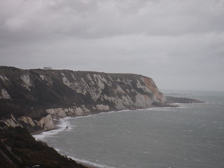
White Cliffs of...
SWC Walk 93 - North Downs Way: Sandling to Folkestone or Dover
Oct-17 • thomasgrabow on Flickr
swcwalks swcwalk93 banner 37622846682
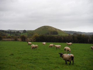
Summerhouse Hill from Bluehouse Wood
SWC Walk 93 - North Downs Way: Sandling to Folkestone or Dover
Oct-17 • thomasgrabow on Flickr
swcwalks swcwalk93 walkicon 37606469876

Brockman's Bushes across valley
SWC Walk 93 - North Downs Way: Sandling to Folkestone or Dover
Oct-17 • thomasgrabow on Flickr
swcwalks swcwalk93 walkicon 37606415126

Along the North Downs, with Brockman's Bushes in the distance
SWC Walk 93 - North Downs Way: Sandling to Folkestone or Dover
Oct-17 • thomasgrabow on Flickr
swcwalks swcwalk93 walkicon 23802391498

Surfer, Folkestone Beach
SWC Walk 93 - North Downs Way: Sandling to Folkestone or Dover
Oct-17 • thomasgrabow on Flickr
swcwalks swcwalk93 walkicon 37655735571
| Length | 17.9 km / 11.1 miles |
|---|---|
| Toughness | 7 out of 10. There are 2 steep climbs near the start, but then largely level walking with only smaller inclines along easy, well maintained paths. The Dover option has an extra hill so 8/10. |
| Map | OS Explorer 138 (Dover) |
| Features |
This walk follows the waymarked North Downs Way (NDW) along the edge of an escarpment with views over the English Channel for almost the entire route. Apart from 2 steep climbs near the start, the route is largely level and easy going, but fairly exposed to the prevailing wind direction. The walk starts by following a dismantled railway line and then a steep climb up a chalky track to Tolsford Hill, with views over the English Channel, to pick up the waymarked North Downs Way (NDW). Heading east, the NDW descends into the Elham Valley and under another disused railway line. There's a second steep climb up a narrow grassy valley on the other side. Navigation along this stretch is a little tricky in places, so do take/print out a map. The rest of the walk is easy, along a level, well maintained path along the side of the escarpment with spectacular views out over the coast, the English Channel, and later Folkestone, and the Channel Tunnel rail terminal. For the rest of the walk, you can see Folkestone, and either of the stations you are aiming for! Just past the viewpoint over Channel Tunnel, by an ancient hill fort, there is an option to cut the walk short to Folkestone West. Note that this involves a long pavement walk to the station. The main walk continues, contouring around the summit of a hill, high above Folkestone, with views out over the channel, until it reaches the coast at the start of the White Cliffs of Dover. Here there is a choice.
|
| Lunch |
The Gatekeeper Inn Canterbury Road, Etchinghill, Folkestone, Kent CT18 8DE, (01303 864345). Open 12.00-late daily. Food served Mon-Fri 12.00-14.30 and 18.00-20.30, Sat 12.00-16.00 and 18.00-20.30, Sun 12.00-17.00. |
| Walk Options |
Bus Line 17 Canterbury - Folkestone passes the lunch pub in Etchinghill, 500m off route, after 5.1 km (hourly Mon-Sat, 2-hourly Sun).
Walk 93A - Sandling to Folkestone WestDrop out early to Folkestone West (but a long 2 km of pavement along a busy road). About 11 km/7 miles Walk 93B - Sandling to Folkestone via the White Cliffs (recommended)The main walk, but adds an out and back walk along the White Cliffs. About 20 km/12 miles Walk 93C - Sandling to Folkestone to DoverContinue along the White Cliffs all the way to Dover. About 21 km/13 miles. The 'Cliff Top Cafe' is the very highly recommended place for a late lunch on this option due to its amazing views. |
| Transport |
Although far from London, Sandling and Folkestone West (hourly) , Folkestone Central and Dover (2/hour) have frequent train service from both London Charing Cross (1hr 30) and St Pancras (High Speed, 1 hr) Suggested Train: Closest to 9:45 (high speed) or 9:15 (low speed) |
| Notes |
|
| North Downs Way |
This walk is a stage of the North Downs Way - a 125 / 131 mile national long distance path - that follows the North Downs ridge in South East England. |
|---|---|
| Profile | |
| Help Us! |
After the walk, please leave a comment, it really helps. Thanks! You can also upload photos to the SWC Group on Flickr (upload your photos) and videos to Youtube. This walk's tags are: |
| By Train | |
| By Car | |
| Map Walk | This walk requires an OS map and a compass or GPS for navigation. You can print out OS maps using the link above. |
| Amazon | |
| Help |
National Rail: 03457 48 49 50 • Traveline (bus times): 0871 200 22 33 (12p/min) • TFL (London) : 0343 222 1234 |
| Version |
Aug-24 Andrew |
| Copyright | © Saturday Walkers Club. All Rights Reserved. No commercial use. No copying. No derivatives. Free with attribution for one time non-commercial use only. www.walkingclub.org.uk/site/license.shtml |


Walk Directions
Sandling station to the NDW (Tolsford Hill)
1km to the motorway crossing, then 2km to the top of the hill
- [Map 1] From the platform at Sandling station that you alight at if coming from Ashford, cross the footbridge to the opposite (i.e. south) platform.
- Pass through or around the station building. On the far side you can find a disused platform with a metal railing along its far edge. Turn left along this, through a metal gate, and carry on off the end of the platform, past a decayed metal gate, onto the track of the old railway line, now a footpath.
- If this way is blocked, go into the station car park on this side of the station, and turn left: a gate at the far end leads onto the old railway line).
- Follow this for 400 metres until you see an old tunnel (concealed by vegetation in spring and summer) about 80 metres ahead. Here veer slightly left up steps (ie leaving the old trackbed and climbing up to the left of the tunnel).
- At the top of the steps follow a gravel path which in 30 metres merges with an earth track coming from a gate to the left. After another 40 metres on this track, you come to a path T-junction, where you go left onto a car-wide path.
- In 300 metres merge with a tarmac drive coming from the right and keep straight on down that.
- In 200 metres you come to a minor road junction: keep straight on here, slightly uphill.
- In 150 metres cross a bridge over the railway (the high speed line to the Channel Tunnel) and beyond that cross a footbridge over the M2 motorway. Keep straight on down a minor road beyond.
- In 150 metres cross a larger road and turn left. In 20 metres turn right through a fieldgate and take the left-hand of two footpaths, the one that veers half left diagonally across a field towards a point about halfway up its left-hand side.
- If this path is not clear or is obscured by crops, stay on the road for another 70 metres and turn right at the next footpath sign up a tarmac track. In 250 metres you pass a house left, and 100 metres later you can resume the directions at point A below.
- In 150 metres the path converges with the field edge and carries on up its left-hand side.
- In 200 metres more, 40 metres before the end of the field, curve left with the path through a field boundary and turn right on a tarmac track.
- [A] In 200 metres pass a house on the left (if following the alternative directions above, this is another house, not the one mentioned there.) 40 metres beyond this, where the tracks fork at a fieldgate, take the right fork, an earth track with a field to the right.
- Keep on this track, ignoring ways off. At the top of the hill, head for the radio masts.
Along the NDW towards Folkestone
- [Map 2] : NDW: At the masts turn right to pick up the North Downs Way (which joins from the left), initially across the grassy plateau, then along the edge of the hill, with a steep drop and spectacular views on your right hand side (1 km).
- NDW: At a wood, turn left downhill with the NDW/SSW. Follow the path downhill. You come to a road.
- Turn left along the road for an optional diversion to the lunch pub in Etchinghill
- NDW: Cross the road, and continue a little to teh right along a drive. Turn left into a pasture (before gate to Coombe Farm). Bear right diagonally through the field and follow path through wood and across stream, then eventually go under a disused railway bridge (1 km). Then, north east, climbing up to the ridge (1 km).
- Map 3] NDW: There are spectacular views over the Channel for the rest of the walk as you again follow the edge of a hill with a steep drop and fine views to your right. Follow the ridge, east then south (2 km).
- NDW: As the path turns east again, you can see the Channel Tunnel terminus below you (rather than being an eyesore, it's actually quite interesting), Folkestone layed out like a map, and the Channel. Follow this path along the edge of the hill above the rail terminus (2.5 km)
- [Map 4] NDW: You reach a traffic free road that goes steeply downhill.
- To cut the walk short: Go down this road. Cross the busy road junction (there are safe pedestrian crossings), and head due south for 2 long km on the pavement of a busy suburban road to Folkestone West station (3 km total)
- NDW: Continue along the NDW, around Caeser's Camp/Castle Hill, a good picnic spot (1 km).
- NDW: Continue following the edge of the hill, high above Folkestone and the Channel (3 km).
- NDW: Eventually you cross a busy road (B 2011), and after 100m, the NDW meets the coast, on a high cliff above a railway line. The area below is The Warren, an undercliff created by land slips.
- At this point you have a choice : 1) follow the coast down into Folkestone, 2) walk along the White Cliffs a little way before returning to this point and taking the Folkestone path, or 3) continuing along the White Cliffs/NDW all the way to Dover
To Finish in Folkestone
- Leave the NDW, and head south on a path downhill towards Folkestone (with the Warren on 1 side, and Folkestone on the other), 0.5 km
- Meet the coast, and follow it past a beach, then the harbour (3.5 km).
- Past the harbour, turn north through eth Old Town, inland towards Folkestone Central station (1 km), or continue along the cliff top promenade to the Folkestone Grand for tea.
To walk along the start of the White Cliffs
- NDW: Continue east, following the NDW. No views at first, but soon you come out on the cliff edge path along the top of the White Cliffs. You pass a pub (The Royal Oak, inland from the path, after 200 m), the Battle of Britain memorial (after 500m), a pub with a view (The Lighthouse Inn, after 1.2 km), and a nice cafe with a stunning view (Clifftop cafe, after 1.4 km).
- At this point continue to Dover or retrace your steps, and take the Folkestone path.
To continue along the cliffs, and Finish in Dover
- [Map 5 and 6] NDW: Continue along the NDW, now more remote along the cliff edge path, eventually leaving the cliff top path to head inland, down into a valley to cross a busy road. 5km.
- [Map 6] NDW: On the outskirts of Dover, pass a couple of housing estates to reach the Western Heights (above Dover centre) with WW2 era remains. 1 km.
- NDE: The NDW comes out on Centre Road, which becomes North Military Road. Leave the NDW by turning left on Malvern Road, then right on Clarendon Road for a short walk inland to Dover Station. 300m