Sheffield Circular via Porter, Limb, Sheaf and Gleadless Valleys Walk
Strenuous excursion through the south westerly wooded valleys of Sheffield

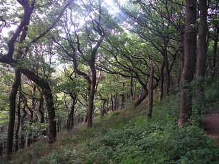
Ancient Oakwood, Ladies' Spring Wood
SWC Walk 267 - Sheffield Circular (via Porter, Limb, Sheaf and Gleadless Valleys)
Jun-16 • thomasgrabow on Flickr
swcwalks swcwalk267 banner walkicon 27253405363

Park Hill Estate
SWC Walk 267 - Sheffield Circular (via Porter, Limb, Sheaf and Gleadless Valleys)
Jun-16 • thomasgrabow on Flickr
swcwalks swcwalk267 walkicon 27587141450

Sheffield General Cemetery, Geological Stone Spiral
SWC Walk 267 - Sheffield Circular (via Porter, Limb, Sheaf and Gleadless Valleys)
Jun-16 • thomasgrabow on Flickr
walkicon swcwalks swcwalk267 27252876374

Stepping Stones in Bingham Park
SWC Walk 267 - Sheffield Circular (via Porter, Limb, Sheaf and Gleadless Valleys)
Jun-16 • thomasgrabow on Flickr
walkicon swcwalks swcwalk267 27587362530

Ochre-coloured Spring, Ecclesall Woods
SWC Walk 267 - Sheffield Circular (via Porter, Limb, Sheaf and Gleadless Valleys)
Jun-16 • thomasgrabow on Flickr
walkicon swcwalks swcwalk267 27587621440
| Length | 27.8 km (17.3 mi), with 664/618m ascent/descent. Shorter versions possible from 15.0 km (9.4 mi) with 325/259m ascent/descent
Buses take you back to the station from various points on the route, for details see below Walk Options. |
|---|---|
| Toughness | 8 out of 10 (up to), with up to 8 hours walking time. For the whole outing, including trains, sights and meals, allow up to 14 hours. |
| Walk Notes |
This walk leads from the hustle and bustle at the centre of one of the most populous British cities through gradually less urban areas into excellent walking country – with ancient escarpment woodlands, tumbling streams, panoramic views and plenty of bluebells in season – through the scenic, wooded valleys of Sheffield’s south west, the greenest and cleanest of Britain’s large towns. Escape from Sheffield’s City Centre, first along streets and through the atmospheric landscaped Victorian General Cemetery, then the woodlands of the municipal Endcliffe Park and the narrow, wooded Porter Valley (part ancient woodlands, part plantation or meadows) to a viewpoint on the edge of moorlands at the fringe of the Peak District, and from there to the early lunch option (with views) in Ringinglow.
|
| Walk Options |
To cut some – or all – of the tarmac-heavy urban stretches at the start, take one of the bus shortcuts, either from Sheffield Interchange (150m from the train station), or a little higher up the hill in the City Centre along Arundel Gate (bus stops change all the time, check online for up-to-date information).
You can take a train back to Sheffield from Dore & Totley Station (15.0 km/9.4 mi) on the Hope Valley Line (8 mins journey time).
|
| Maps | OS Explorer: 278 (Sheffield & Barnsley)
OS Landranger: 110 (Sheffield & Huddersfield) Harvey Superwalker XT25: Peak District Central (but only the middle part of the route) Harvey British Mountain Map: Dark Peak (but only the middle part of the route) |
| Travel |
Sheffield (Midland) station, map reference SK 359 870, is 227 km north north west of Charing Cross, 54m above sea level, and in South Yorkshire. It is the terminus of the Midland Main Line from London St. Pancras, with up to two trains per hour (journey time from 118 mins Mondays-Saturdays, longer on Sundays). Hunter’s Bar roundabout, map reference SK 332 857 and where the full route finishes, has several bus stops and many lines connecting back to Sheffield Interchange, which is close to the train station. Saturday Walkers' Club: Take a train no later than 9.00 hours. |
| Elevenses and Lunch |
Endcliffe Park Café Endcliffe Park, Sheffield, South Yorks, S11 7AB (0114 266 3044). The Endcliffe Park Café is located 4.1 km (2.6 mi) into the walk.
|
| Tea |
The Rose Garden Café Graves Park, Hemsworth Road, Sheffield S8 8LL (0114 258 2705). The Rose Garden Café is located 60m off-route, 20.4 km (12.7 mi) into the walk, and a timber framed café.
|
| Profile | |
|---|---|
| Help Us! |
After the walk, please leave a comment, it really helps. Thanks! You can also upload photos to the SWC Group on Flickr (upload your photos) and videos to Youtube. This walk's tags are: |
| By Train |
Out (not a train station) Back (not a train station) |
| By Car |
Start Map Directions |
| Amazon | |
| Help |
National Rail: 03457 48 49 50 • Traveline (bus times): 0871 200 22 33 (12p/min) • TFL (London) : 0343 222 1234 |
| Version |
Apr-25 Thomas G |
| Copyright | © Saturday Walkers Club. All Rights Reserved. No commercial use. No copying. No derivatives. Free with attribution for one time non-commercial use only. www.walkingclub.org.uk/site/license.shtml |
Walk Directions
Full directions for this walk are in a PDF file (link above) which you can print, or download on to a Kindle, tablet, or smartphone.
This is just the introduction. This walk's detailed directions are in a PDF available from wwww.walkingclub.org.uk
