Worth Matravers Circular Walk
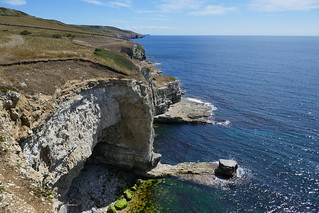
Purbeck: Keats (dinosaur footprints) and Winspit (swimming) quarries, Chapman's Pool (hidden beach), and Jurassic Coast views.


| Length | 10km (6.2 miles). If starting in Langton Matravers (bus) add 2-3km. |
|---|---|
| Toughness | 7 out of 10, because it includes two very steep descents and steep ascents. |
| OS Maps | OL15:Purbeck & South Dorset |
| Features |
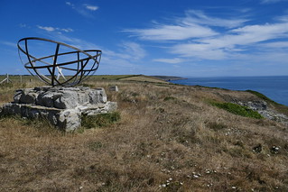
See Keates Quarry Dinosaur footprints, then descend to the South West Coast Path (SWCP), pass Winspit quarry (good rock climbing and swiming access), with beautiful views of the Jurassic Coast all the way to Portland. See the radar memorial in St Aldhelms head. Descend to Chapman's pool for a swim and fossil hunting. Then back up to the start. |
| Walk Options |
You can do this walk clockwise or anticlockwise but I suggest you do this clockwise, if starting before noon the sun will be behind you and the views will be better, you also get to finish with a swim in Chapman's pool. The walk itself will take about 4h at a leisurely pace. About 6h if you go for a swim, fossil hunting and lunch. If you have a full day, you can extend this walk on the SWCP as much as you want, you can include:
Worth and Langton have several campsites and cottages to stay overnight if you want to spend some days in the area and do more sections of the SWCP (totally recommended). |
| History |
This is part of the Jurassic Coast, so a geology and palenteology paradise. The Jurassic Coast is a World Heritage Site that starts in Exmouth and ends in Swanage. Because the rock layers are tilted, you can see from West to East rocks spanning from the Triassic, Jurassic and Cretaceous. This walk covers two very good fossil locations. Keates Quarry (National Trust) has fossilised tracks of dinosaurs, 140 million years old and Chapman's pool has a lot of ammonite fossils. The limestone in the area (Portland stone) was extensively quarried, Winspit is a great example. It was used as a quarry until 1940 when it was turned into a naval and airbase during WWII. During WWII Worth Matravers was the centre of early radar development, there is a memorial to conmemorate this since after a successful raid of a German radar base, Churchill urgently moved the Telecommunications Research Centre from Worth to avoid retaliation from the germans. The Square and Compass pub in Worth Matravers dates back to the 18th century. It became a pub in 1776 and had connections with smuggling. In 1830 it became the Square and Compass since the landlord was a stonemason. The pub has a small fossil collection. It is well worth a visit. |
| Travel |
If using a car, you can park in Worth Matravers (BH19 3LE, £2 for the day). If by public transport there are direct trains from London Waterloo to Wareham and then take bus 40 towards Swanage, get off in Langton Matravers. For bus timetables check morebus.co.uk |
| Lunch/Tea | Have a meal at The Square and Compass pub in Worth Matravers at the end of the walk, or take a packed lunch to Chapmans Pool. Langton Matravers and Swanage also have lovely traditional pubs. |
| Notes |
A detailed description of the walk is not provided, a gpx route is available for download. Please note the following:
|
| Updates | First edition, July 2020 |
| Profile | |
|---|---|
| Help Us! |
After the walk, please leave a comment, it really helps. Thanks! You can also upload photos to the SWC Group on Flickr (upload your photos) and videos to Youtube. This walk's tags are: |
| By Car |
Start Map Directions |
| Amazon | |
| Help |
National Rail: 03457 48 49 50 • Traveline (bus times): 0871 200 22 33 (12p/min) • TFL (London) : 0343 222 1234 |
| Version |
Aug-20 DSG |
| Copyright | © Saturday Walkers Club. All Rights Reserved. No commercial use. No copying. No derivatives. Free with attribution for one time non-commercial use only. www.walkingclub.org.uk/site/license.shtml |


