Olympic Park, Hackney Wick and Fish Island Short Walk
The Olympic Park, waterways, wetlands, and former industrial areas

Olympic Rings on hillock
SWC Short Walk 27 - The Olympic Park, Hackney Wick and Fish Island
Apr-17 • thomasgrabow on Flickr
swcwalks short27 banner 35332497191

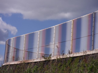
LFO Spectrum, by Carsten Nicolai
SWC Short Walk 27 - The Olympic Park, Hackney Wick and Fish Island
Apr-17 • thomasgrabow on Flickr
swcwalks short27 walkicon 35332459541

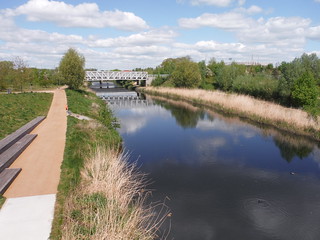
River Lea
SWC Short Walk 27 - The Olympic Park, Hackney Wick and Fish Island
Apr-17 • thomasgrabow on Flickr
swcwalks short27 walkicon 35422879116

ArcelorMittal Orbit and Fountain
SWC Short Walk 27 - The Olympic Park, Hackney Wick and Fish Island
Apr-17 • thomasgrabow on Flickr
swcwalks short27 walkicon 34652828243

Robert, the heritage locomotive
SWC Short Walk 27 - The Olympic Park, Hackney Wick and Fish Island
Apr-17 • thomasgrabow on Flickr
swcwalks short27 34621555074
| Start and Finish | Stratford Main Line Rail/DLR/Overground/Underground station. |
|---|---|
| Length |
8.5 km/5.3 mi or 9.3 km/5.8 mi |
| Time | 2 ¼ hours or 2 ½ hours |
| Travel |
Stratford Station is served by Main Line Services from Liverpool Street, by the DLR and by the Central and Jubilee Lines, and is also a terminus for the Mildmay Line of the Overground to Richmond via Highbury & Islington. |
| Walk Notes |
This walk follows a meandering route through Stratford City, a development preceding the idea of London applying to hold the Olympic Games, and including the very large Westfield Shopping Centre, as well as through the neighbouring Olympic Park and past its surviving Olympic venues, one of the largest urban parks created in Western Europe for more than 150 years, and designed to enrich and preserve the local environment, by restoring wetland habitats and planting native species of plants along the River Lea and the Bow Backwaters. It is still a work in progress, in its continued transition from sports venue to public park, with many new neighbourhoods and amenities added since the 2012 Games.
In the park itself there are lots of changes of level to introduce the many diverse areas: in the South Park the feel is quite urban, as you are surrounded by sport events’ structures, lots of trees and wide promenades, all landscaped to look quite formal, almost Continental; while the North Park is wilder, landscaped to look – within the limits of the site – like an English Country Park, including some wetlands, meadows, ponds and flood plains, all designed to create a haven for plants and wildlife.
Generally, plantings are deliberately left semi-wild/informal for cost and aesthetic reasons.
|
| Walk Options |
For shorter walk, start from Stratford International Mainline or DLR Stations, passed after 750m.
|
| Eat and Drink |
Plenty of options en route, for details please check the pdf. |
| Profile | |
|---|---|
| Help Us! |
After the walk, please leave a comment, it really helps. Thanks! You can also upload photos to the SWC Group on Flickr (upload your photos) and videos to Youtube. This walk's tags are: |
| By Car |
Start Map Directions Finish Map Directions |
| Amazon | |
| Help |
National Rail: 03457 48 49 50 • Traveline (bus times): 0871 200 22 33 (12p/min) • TFL (London) : 0343 222 1234 |
| Version |
Feb-24 Thomas G |
| Copyright | © Saturday Walkers Club. All Rights Reserved. No commercial use. No copying. No derivatives. Free with attribution for one time non-commercial use only. www.walkingclub.org.uk/site/license.shtml |
Walk Directions
Full directions for this walk are in a PDF file (link above) which you can print, or download on to a Kindle, tablet, or smartphone.
This is just the introduction. This walk's detailed directions are in a PDF available from wwww.walkingclub.org.uk
