Bedwyn Circular via Savernake Forest and Marlborough Walk
More veteran trees than anywhere else in Europe, undulating pastures, historic Marlborough and the landscaped Tottenham Park
![Cathedral Oak, Savernake Forest SWC 399 - Bedwyn Circular (via Savernake Forest and Marlborough) [Young Paunchy and Cathedral Oak Loop]](https://live.staticflickr.com/65535/52421348591_e7c6906dc1_n.jpg)
Cathedral Oak, Savernake Forest
SWC 399 - Bedwyn Circular (via Savernake Forest and Marlborough) [Young Paunchy and Cathedral Oak Loop]
Aug-22 • thomasgrabow on Flickr
swcwalks swcwalk399 banner 52421348591

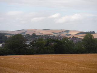
Views across Kennet Valley from lane to Brown's Farm
SWC 399 - Bedwyn Circular (via Savernake Forest and Marlborough)
Aug-22 • thomasgrabow on Flickr
swcwalks swcwalk399 walkicon 52421350576

A very old oak tree, after re-entering Savernake Forest
SWC 399 - Bedwyn Circular (via Savernake Forest and Marlborough)
Aug-22 • thomasgrabow on Flickr
swcwalks swcwalk399 walkicon 52421634284
![Spider Oak, Savernake Forest, off Postwives Walk SWC 399 - Bedwyn Circular (via Savernake Forest and Marlborough) [King and Queen Oaks Loop]](https://live.staticflickr.com/65535/52420839402_7b3dfab582_m.jpg)
Spider Oak, Savernake Forest, off Postwives Walk
SWC 399 - Bedwyn Circular (via Savernake Forest and Marlborough) [King and Queen Oaks Loop]
Aug-22 • thomasgrabow on Flickr
swcwalks swcwalk399 walkicon 52420839402

Ailesbury Column in the sun, Savernake Forest
SWC 399 - Bedwyn Circular (via Savernake Forest and Marlborough)
Aug-22 • thomasgrabow on Flickr
swcwalks swcwalk399 walkicon 52421863533
| Length |
31.0 km (19.3 mi) with 407m ascent/descent. For a shorter or a longer walk, see below Walk Options. |
||||||||||||||||||||||||||||||||||||||||||||||||||||||||||||||||||||||||||||||||||||||||||||||||
|---|---|---|---|---|---|---|---|---|---|---|---|---|---|---|---|---|---|---|---|---|---|---|---|---|---|---|---|---|---|---|---|---|---|---|---|---|---|---|---|---|---|---|---|---|---|---|---|---|---|---|---|---|---|---|---|---|---|---|---|---|---|---|---|---|---|---|---|---|---|---|---|---|---|---|---|---|---|---|---|---|---|---|---|---|---|---|---|---|---|---|---|---|---|---|---|---|---|
| Toughness |
7 out of 10, with 7 hours walking time. For the whole outing, including trains, sights and meals, allow at least 10 ½ hours. |
||||||||||||||||||||||||||||||||||||||||||||||||||||||||||||||||||||||||||||||||||||||||||||||||
| Walk Notes |
A meandering route through Savernake Forest with its veteran trees and through historic Marlborough. Savernake Forest today is just a fraction of its historical size, but yet is the largest privately owned forest in Britain. It stands on a Cretaceous chalk plateau within the North Wessex Downs AONB, presenting as rolling downland serrated by four shallow dry and wet valleys. This creates the damp heavy soils well suited to oak and beech woods. Pollarding has taken place for many generations, leading to the trees developing sizeable girths and having curved pieces of bows. Some of the picturesque veteran trees are over 1,000 years old and many have recently been protected, named and signed. More than 20 of the named trees are passed on this walk, as well as numerous other grand oak, beech and chestnut specimen.
Amongst the many walk options are several out-and-backs or loops to or past veteran trees not on the main walk, as well as one through the Chisbury Camp hillfort site. |
||||||||||||||||||||||||||||||||||||||||||||||||||||||||||||||||||||||||||||||||||||||||||||||||
| Walk Options |
A slightly longer start leads through the wooded Chisbury Camp hillfort Site and enables a look at the early 13th century St. Martin’s Chapel (English Heritage), this adds 750m and 20m ascent.
| ||||||||||||||||||||||||||||||||||||||||||||||||||||||||||||||||||||||||||||||||||||||||||||||||
| Maps |
OS Landranger Map: 173 (Swindon & Devizes)
|
||||||||||||||||||||||||||||||||||||||||||||||||||||||||||||||||||||||||||||||||||||||||||||||||
| Travel |
Bedwyn Station, map reference SU 279 644, is 103 km west south west of London, 120m above sea level and in Wiltshire. It is on the Berkshire and Hampshire line from London Paddington. The journey time is from 65 minutes. Currently, a change is needed at Reading or Newbury. A Newbury – Bedwyn train will wait for up to 5 minutes for a delayed train from Paddington. Saturday Walkers’ Club: Take the train closest to 09.00 hours. | ||||||||||||||||||||||||||||||||||||||||||||||||||||||||||||||||||||||||||||||||||||||||||||||||
| Lunch |
Numerous options along Marlborough’s High Street, see the walk directions for details. |
||||||||||||||||||||||||||||||||||||||||||||||||||||||||||||||||||||||||||||||||||||||||||||||||
| Tea |
The Three Tuns Freehouse 1 High Street, Great Bedwyn, Marlborough, Wiltshire, SN8 3NU (01672 870 280). The Three Tuns is located 300m from the end of the walk. |
||||||||||||||||||||||||||||||||||||||||||||||||||||||||||||||||||||||||||||||||||||||||||||||||
| Named Significant Trees on route |
| ||||||||||||||||||||||||||||||||||||||||||||||||||||||||||||||||||||||||||||||||||||||||||||||||
| Profile | |
|---|---|
| Help Us! |
After the walk, please leave a comment, it really helps. Thanks! You can also upload photos to the SWC Group on Flickr (upload your photos) and videos to Youtube. This walk's tags are: |
| By Train |
Out (not a train station) Back (not a train station) |
| By Car |
Start Map Directions |
| Amazon | |
| Help |
National Rail: 03457 48 49 50 • Traveline (bus times): 0871 200 22 33 (12p/min) • TFL (London) : 0343 222 1234 |
| Version |
May-23 Thomas G |
| Copyright | © Saturday Walkers Club. All Rights Reserved. No commercial use. No copying. No derivatives. Free with attribution for one time non-commercial use only. www.walkingclub.org.uk/site/license.shtml |
Walk Directions
Full directions for this walk are in a PDF file (link above) which you can print, or download on to a Kindle, tablet, or smartphone.
This is just the introduction. This walk's detailed directions are in a PDF available from wwww.walkingclub.org.uk
