Haddenham to Aylesbury via Gibraltar and Ford Walk
The scenic heart of Aylesbury Vale: picturesque hamlets in the Thame Valley, Notley Abbey, Dinton Hall and Hartwell House.

Dinton Hall, from footpath to the SE
SWC Walk 193 Haddenham to Aylesbury (via Gibraltar and Ford)
Mar-16 • thomasgrabow on Flickr
swcwalks swcwalk193 banner walkicon 26120340255

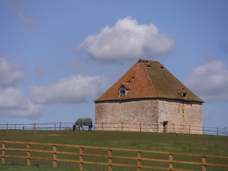
Dovecote, Notley Farm
SWC Walk 193 Haddenham to Aylesbury (via Gibraltar and Ford)
Mar-16 • thomasgrabow on Flickr
walkicon swcwalks swcwalk193 25515791014

Pollards along the Thame River, Chearsley
SWC Walk 193 Haddenham to Aylesbury (via Gibraltar and Ford)
Mar-16 • thomasgrabow on Flickr
walkicon swcwalks swcwalk193 25515735524

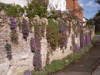
Garden Wall in Cuddington
SWC Walk 193 Haddenham to Aylesbury (via Gibraltar and Ford)
Mar-16 • thomasgrabow on Flickr
walkicon swcwalks swcwalk193 25847559300

Pulpit Hill, Chilterns, from field in Dinton
SWC Walk 193 Haddenham to Aylesbury (via Gibraltar and Ford)
Mar-16 • thomasgrabow on Flickr
walkicon swcwalks swcwalk193 26053920391
| Path closed for HS2 Works |
As of Q122, HS2 have closed the footpath north east of Hartwell House near the end of the route for safety reasons until at least late 2024, as the right of way crosses a work access road busy with trucks and dippers. No feasible alternative route is available. It is therefore recommended to finish the walk at the bus stop by The Bugle Horn in Stone/Hartwell, for a bus back to Haddenham or on to Aylesbury. The locations of bus stop and path closure are marked on the route map. |
|---|---|
| Length |
23.4 km (14.6 mi), with 177/180m ascent/descent. For a shorter walk see below Walk Options. |
| Toughness |
3 out of 10, with 5 hours walking time. For the whole outing, including trains, sights and meals, allow at least 7 hours and 45 minutes. |
| Walk Notes |
This pleasant walk through the scenic heart of Aylesbury Vale provides for fine views of the Chiltern ridge as well as to other surrounding hills to the north, as it passes through the tranquil Thame Valley, linking up several unspoilt and picturesque hamlets, while passing four good village pubs en route.
The regular Oxford to Aylesbury bus service is never far away from the route, making it easy to choose a shorter option. |
| Walk Options |
The Oxford to Aylesbury bus route (200/280) along the A418 offers an option for a shorter walk, either taking you back to Haddenham station or on to Aylesbury bus station (200m from the rail station). It runs every 20 minutes weekdays, half-hourly Saturdays and hourly Sundays, and you can catch it from many points along the route, either after lunch in Gibraltar or Dinton, near Dinton Church (halfway through the walk), or later in the afternoon in Hartwell (4 km from the end). Details are to be found in the walk directions. |
| Maps |
OS Explorer: 181 (Chiltern Hills North) and 180 (Oxford)
|
| Transport |
Haddenham & Thame Parkway (HTP) station, map reference SP 731 085, is 10 km south west of Aylesbury, 22km east of Oxford, and 81m above sea level. Aylesbury Station, map reference SP 817 134, is 78m above sea level. Both are in Buckinghamshire. HTP station is on the London Marylebone to Bicester main line. Aylesbury is on the Marylebone to Aylesbury line (also operated by Chiltern Railways), but is also served via a loop branching off from the Bicester line at Princes Risborough. Buy an ‘Aylesbury Return (any route permitted)’-ticket, this covers the outward journey up to Princes Risborough. You might then have to pay on board for a single Princes Risborough to HTP extension (there are no barriers at HTP). Journey times are between 34 and 51 minutes to HTP, with two trains per hour, and between 60 and 70 minutes from Aylesbury, with three trains per hour. Saturday Walkers’ Club: Take the train closest to 9.30 hours. |
| Lunch |
The Crown at Cuddington Aylesbury Road, Cuddington, Buckinghamshire, HP18 0BB (01844 292 222). The Crown is located 7.1 km (4.4 mi) into the walk and a characterful Grade II listed pub.
|
| Tea |
The Bugle Horn Oxford Road, Hartwell, Aylesbury, Buckinghamshire, HP17 8QP (01296 747 594). The Bugle Horn is located 19.6 km (12.2 mi) into the walk and 3.7 km from the end of it. It started life as a farmhouse, but during the early 1800s it was used as a wine store for Hartwell House, whilst Louis XVIII of France lived there in exile. Initially known as the Plough, the current name comes from the fossils of the same name that can be seen in the pub’s walls.
A plethora of options in Aylesbury City Centre (see Walk Directions pdf), recommended is:
|
| Profile | |
|---|---|
| Help Us! |
After the walk, please leave a comment, it really helps. Thanks! You can also upload photos to the SWC Group on Flickr (upload your photos) and videos to Youtube. This walk's tags are: |
| By Train |
Out (not a train station) Back (not a train station) |
| By Car |
Start Map Directions Return to the start: Finish Map Directions Travel to the start: |
| Amazon | |
| Help |
National Rail: 03457 48 49 50 • Traveline (bus times): 0871 200 22 33 (12p/min) • TFL (London) : 0343 222 1234 |
| Version |
Aug-21 Thomas G |
| Copyright | © Saturday Walkers Club. All Rights Reserved. No commercial use. No copying. No derivatives. Free with attribution for one time non-commercial use only. www.walkingclub.org.uk/site/license.shtml |
Walk Directions
Full directions for this walk are in a PDF file (link above) which you can print, or download on to a Kindle, tablet, or smartphone.
This is just the introduction. This walk's detailed directions are in a PDF available from wwww.walkingclub.org.uk
