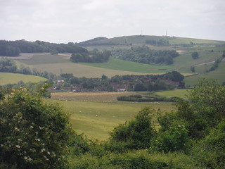
Halnaker to Chichester via Goodwood Walk
Scenic steep chalk downlands around the Upper Lavant Valley, the Goodwood Estate and unrivalled views from St. Roche's Hill

Northerly View from The Trundle: Singleton and the Rother Valley through gap in South Downs main ridge
SWC Walk 239 Halnaker to Chichester via Cass Sculpture Park and Goodwood
Aug-17 • thomasgrabow on Flickr
swcwalks swcwalk239 banner 35572704784

St. Roche’s Hill behind Charlton
SWC Walk 239 Halnaker to Chichester via Cass Sculpture Park and Goodwood
Jun-15 • thomasgrabow on Flickr
swcwalks swcwalk239 walkicon 19065895916

Boxgrove Priory's Guest House Ruins
SWC Walk 239 Halnaker to Chichester via Cass Sculpture Park and Goodwood (Boxgrove Priory out-and-back)
Aug-17 • thomasgrabow on Flickr
swcwalks swcwalk239 walkicon 36270923921

Goodwood Race Course from The Trundle
SWC Walk 239 Halnaker to Chichester via Cass Sculpture Park and Goodwood
Aug-17 • thomasgrabow on Flickr
swcwalks swcwalk239 walkicon 36362970976

Chichester and Cathedral across fields (from St. Roche's Hill)
SWC Walk 239 Halnaker to Chichester via Cass Sculpture Park and Goodwood
Aug-17 • thomasgrabow on Flickr
swcwalks swcwalk239 walkicon 36011327030
| Length |
22.9 km (14.2 mi), with 475/501m ascent/descent. For a shorter or longer walk see below Walk Options. |
|---|---|
| Toughness |
6 out of 10 (with several steep ascents around lunch, so may feel tougher than that), with 5 hours 30 minutes walking time.
|
| Walk Notes |
This West Sussex walk makes for a relatively long day out for the length of the walk, as it involves a bus connection to the start after an already long train journey to Chichester. Its main purpose is to explore the scenic steep chalk downlands well north of Chichester around the Upper Lavant Valley, between St. Roche’s Hill and the South Downs chain, while passing through the Goodwood estate as well as through Chichester’s Old Town at the end. The lonely grassy or wooded hillsides of the beautiful Lavant Valley are dissected by quiet flat-bottomed valleys, and feature several pretty villages, as well as providing for stunning views. Most of the climbing is done between the lunch pubs, but the longest ascent comes straight after the late lunch option, up to St. Roche’s Hill, from whose treeless summit you have grand views in all directions. Optional out-and-backs at the start, to Halnaker Hill (with its windmill) and/or Boxgrove Priory, make it an up to 30 km walk. |
| Walk Options |
Out-and-backs at the start to Halnaker Hill or Boxgrove Priory add 5.1 and 2.6 km respectively.
|
| Maps |
OS Explorer: OL8 (Chichester) and OL10 (Arundel & Pulborough)
|
| Travel |
Halnaker Crossroads, map reference SU 907 080, is 6 km north east of Chichester and 37m above sea level. Chichester Station, map reference SU 858 043, is 22 km east of Portsmouth and 11m above sea level. Both are in West Sussex. Halnaker Crossroads is a stop on the number 55 bus service from Chichester to Tangmere. The service runs every 20 minutes Mon-Fri, half-hourly Sat and hourly on Sundays. It is seamlessly linked to (on-time) trains arriving from London. It then takes 21 minutes to Halnaker (with a fare of £3.80 in 06/22). Chichester station is on the London Victoria to Southampton West Coastway Line. Journey times (two trains an hour) are 91 minutes Monday to Saturday and 106 minutes on Sunday. Saturday Walkers’ Club: Take the train closest to 9.30 hours (but earlier if aiming for the late lunch pub in Singleton). |
| Lunch |
The Star and Garter, East Dean, West Sussex, PO18 0JG (01243 811 318). The Star and Garter is located 5.6 km (3.5 mi) into the walk and is a flint and brick country pub with rooms.
|
| Tea |
Plenty of options in West Dean, Lavant and Chichester. See the pdf for details. |
| Profile | |
|---|---|
| Help Us! |
After the walk, please leave a comment, it really helps. Thanks! You can also upload photos to the SWC Group on Flickr (upload your photos) and videos to Youtube. This walk's tags are: |
| By Train |
Back (not a train station) |
| By Car |
Start Map Directions Finish Map Directions |
| Amazon | |
| Help |
National Rail: 03457 48 49 50 • Traveline (bus times): 0871 200 22 33 (12p/min) • TFL (London) : 0343 222 1234 |
| Version |
Jun-22 Thomas G |
| Copyright | © Saturday Walkers Club. All Rights Reserved. No commercial use. No copying. No derivatives. Free with attribution for one time non-commercial use only. www.walkingclub.org.uk/site/license.shtml |
Walk Directions
Full directions for this walk are in a PDF file (link above) which you can print, or download on to a Kindle, tablet, or smartphone.
This is just the introduction. This walk's detailed directions are in a PDF available from wwww.walkingclub.org.uk


