Lulworth Cove via Tyneham and Durdle Door Circular Walk
Dramatic coastal scenery, Lulworth cove, hidden beaches, Durdle Door cliff arch, and a ghost town.

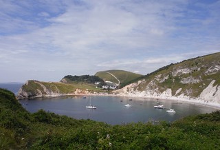
Lulworth Cove and Hambury Tout
SWC Walk 54 - Lulworth Cove Circular (via Tyneham and Durdle Door)
Jul-17 • thomasgrabow on Flickr
banner swcwalks swcwalk54 48437504921

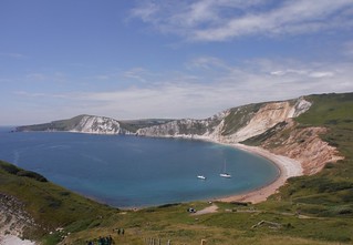
Worbarrow Bay to Mupe Bay, from Ascent up Gad Cliff
SWC Walk 54 - Lulworth Cove Circular (via Tyneham and Durdle Door)
Jul-17 • thomasgrabow on Flickr
banner swcwalks swcwalk54 48437643342

Easterly Backview from Bindon Hill
SWC Walk 54 - Lulworth Cove Circular (via Tyneham and Durdle Door)
Jul-17 • thomasgrabow on Flickr
banner swcwalks swcwalk54 48437639792

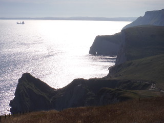
Westerly View from halfway up Hambury Tout
SWC Walk 54 - Lulworth Cove Circular (via Tyneham and Durdle Door)
Jul-17 • thomasgrabow on Flickr
banner swcwalks swcwalk54 48437638252

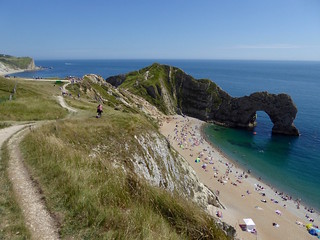
The coast path at Durdle Door
Jul-17 • Saturdaywalker on Flickr
swcwalks walkicon swcwalk54 35223467483
| Danger Area |
The Tyneham Loop of this walk leads through the Lulworth Army Firing Range, part of the Armoured Fighting Vehicles Gunnery School. It is open a) most weekends and b) school holidays (i.e. it's closed most weekdays and a few weekends). Check before travelling! If closed, you can always do the Durdle Door Loop, and a short part of the Tyneham Loop above Lulworth Cove, to and from the Range boundary. | ||||||||||||
|---|---|---|---|---|---|---|---|---|---|---|---|---|---|
| Length |
| ||||||||||||
| Toughness |
8 out of 10, with 6 ½ hours walking time. For the whole outing, including trains, sights and meals, allow at least 13 ½ hours. | ||||||||||||
| Walk Notes |
This is a beautiful and challenging coastal walk along Purbeck's Jurassic Coast. It takes int he iconic Lulworth Cove, Durdle Door (an arch), dramatic white cliff coastal scenery, and the WW2 abandoned and ruined village of Tyneham. The walk is a 'dog bone' shape, centred on Lulworth Cove. The 2 independent loops can be done on their own, and with a car, you can skip the strenuous link between them.
Public transport from Wool Station to Lulworth Cove is infrequent, seasonal, and changes every year! There is a link Route from Wool Station to Arish Mell (near the middle of the link between the 2 loops). This makes the walk independent of the seasonal bus service and/or taxis, while enabling variations of the walk, cutting out some of the steep ascents. Warning: the Tyneham Loop, and the link from Lulworth Cove goes through the Lulworth Live Firing Ranges. Access is only permitted along the marked Range Walks and only at certain times (most weekends and assorted holiday periods). See below for exact dates. | ||||||||||||
| Walk Options |
Tyneham and Durdle Door Loops
The walk route is a dog-bone/figure-of-eight with the start at Lulworth Cove, the junction of the two loops. You can therefore walk just one of those loops, or walk them in a different order than the directions suggest, or even over two days (there are plenty of accommodation options in West Lulworth):
A link route between Wool station and the walk route at Arish Mell beach (in the middle of the Tyneham loop) has been described in both directions, so you can reduce your reliance on a bus or a taxi at start and finish and can also combine this route with parts of the full walk.
| ||||||||||||
| Maps |
OS Explorer: OL15 (Purbeck & South Dorset)
| ||||||||||||
| Travel |
Lulworth Cove bus stop, map reference SY 822 800, is 178 km south west of Charing Cross, 16m above sea level and in Dorset. Wool Station is on the Waterloo to Weymouth Main Line, with one train per hour (journey time 149 mins Mondays-Saturdays, 154 mins on Sundays). The following buses connect Wool Station to Lulworth Cove (ca. £2.00 each way): Purbeck Breezer 30 (late May-late Sep: daily, but weekdays only most of June); X54 (Oct-Mar: Mon-Fri, Apr-Sep: daily); 55 (summer weekends only, but daily during Dorset summer holidays). Saturday Walkers’ Club: Take a train no later than 8.05 hours. | ||||||||||||
| Lunch and Tea |
Lulworth Cove Inn, Main Road, West Lulworth, Wareham, Dorset, BH20 5RQ (01929 400 333).
See the pdf for details. | ||||||||||||
| Links |
Tyneham Village was evacuated at short notice by the army during WWII to prepare troops for D-Day, but the villagers were never allowed back. The village church, rows of cottages, the school (now a museum, free) and some ruined house remain. The sign on the church reads: Please treat the church and houses with care; we have given up our homes where many of us lived for generations to help win the war to keep men free. We shall return one day and thank you for treating the village kindly.
| ||||||||||||
| Lulworth Cove |
Lulworth Cove, nearby Durdle Door (a cliff arch) and the dramatic white cliffs' coastal scenery are stunningly beautiful, and very popular and busy on sunny summer weekends. TravelWool Station is 7 kilometres north of Lulworth Cove on the Waterloo to Weymouth Main Line. Trains are hourly. Journey time 149 mins Mondays-Saturdays, 154 mins on Sundays. Wool Station to Lulworth Cove: bus or taxiUpdated : July 2023 (but bus fare as of 07/22). Check online before you go, as recently these bus services have changed every year! Check Traveline South West.
Wool has two pubs close to the station to await your train, and a local store that keeps long hours every day. By CarAbout 3 hours drive from London.
StayWest Lulworth has a YHA youth hostel, a HF hotel, a campsite (mostly caravans, but they take tents), and B&Bs and Hotels. |
|---|---|
| Lulworth Ranges Danger Area |
This is an army live firing range around Tyneham, just to the east of Lulworth Cove.
It is only open at certain times. Access is allowed along marked Range Walks. They are shown on OS maps.
Lulworth Range WalksThe Range Walks are open
Latest updates : MOD : Lulworth Access Times Lulworth Range walks and Tyneham Village Opening Times Open every weekend (4:30pm Fri to 8am Mon) with the exception of the following: closed weekends 18 to 19 January 2025 15 to 16 March 2025 14 to 15 June 2025 13 to 14 September 2025 11 to 12 October 2025 15 to 16 November 2025 On completion of firing the gates to the walks are opened as near as possible to 16.30 on the Friday afternoon. Please note that this is dependent on completion of range clearance and weather. The gates will then remain open until 8.00 on the Monday morning. In addition to the weekends they are open every day during the following times (all dates are inclusive): 2024 open days Christmas: 21 Dec 2024 to 5 Jan 2025 Easter: 5 April to 21 April 2025 Bank Holiday: 3 to 5 May 2025 Spring stand-down: 24 May to 01 Jun 2025 Summer stand-down: 25 July to 31 August 2025 Christmas: 20 Dec 2025 to 4 Jan 2026 |
| Profile | |
| Help Us! |
After the walk, please leave a comment, it really helps. Thanks! You can also upload photos to the SWC Group on Flickr (upload your photos) and videos to Youtube. This walk's tags are: |
| By Car |
Start Map Directions |
| Amazon | |
| Help |
National Rail: 03457 48 49 50 • Traveline (bus times): 0871 200 22 33 (12p/min) • TFL (London) : 0343 222 1234 |
| Version | |
| Copyright | © Saturday Walkers Club. All Rights Reserved. No commercial use. No copying. No derivatives. Free with attribution for one time non-commercial use only. www.walkingclub.org.uk/site/license.shtml |
Walk Directions
Full directions for this walk are in a PDF file (link above) which you can print, or download on to a Kindle, tablet, or smartphone.
This is just the introduction. This walk's detailed directions are in a PDF available from wwww.walkingclub.org.uk
This walk is a "figure of 8" - 2 loops centred on Lulworth Cove. You can start anywhere
These instructions are based on parking at Povington Hill car park, above Tyneham, but its possible to start anywhere along the route, e.g. Lulworth Cove car parkThe East Loop - Tyneham
- Head inland along Lulworth Cove road, then take a path up then east over Bindon Hill.
- Rejoin the SWCP. There is a killer descent then ascent.
- At Flowers Barrow, a dramatic viewpoint, leave the SWCP, and follow the ridge east to Povington Hill, until you reach a downhill track to your left
- A little further along the ridge is Povington Hill car park (free, marked on the OS map). From the car park, head west along the ridge to reach this point
- Take the track south, downhill into the valley, to Tyneham Village, which you can see down to your right
- After exploring the village continue south, and climb up to Gad Cliff on the opposite side of the valley
- Detour east towards Tyneham Cap to enjoy the view, before returning to this point
- Follow the SWCP west, past Worbarrow Tout and Worbarrow Bay (Tyneham's pretty beach) then a murderous climb up to the dramatic Flowers Barrow (viewpoint)
- Continue on the SWCP, down to Mupe bay, and another murderous climb, continue along the coast until you reach Lulworth Cove
- Lunch/Tea is at the Lulworth Cove Inn
The West Loop - Durdle Door and Swyre Head
- Head west along the coast path, following the SWCP towards Durdle Door. You pass Stair Hole (a cove in the making), and above St Oswalds Bay (access is from Durdle Door)
- Vist Durdle Door.
- Continue along the coast, turn back a km or so past Swyre Head
- Return slightly inland, and higher up, with less ups and downs, along the path parallel to the coast, marked on the OS map.
- Pass north of the caravan park, then go south east (south of the minor road) to meet a track going to the Lulworth Cove Road
- Head south along the road to the pub and car-park
- Lunch/Tea is at the Lulworth Cove Inn


