Wendover Circular via The Lee and Swan Bottom Walk
Along the Ridgeway through the Chiltern Hills and through many splendid woodlands, a conservation village and idyllic Lee Common
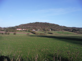
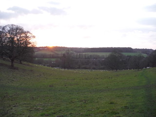
Boddington Hill Iron Age Hillfort Site, from the Ridgeway
SWC Walk 140a Wendover to Great Missenden
Dec-15 • thomasgrabow on Flickr
swcwalks swcwalk140 walkicon banner 23566502132
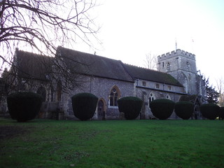
St. Mary's Church, Wendover
SWC Walk 140a Wendover to Great Missenden
Dec-15 • thomasgrabow on Flickr
walkicon swcwalks swcwalk140 23379439130
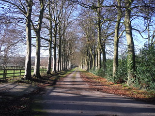
Approach Lane to Boswells Farm, Wendover
SWC Walk 140a Wendover to Great Missenden
Dec-15 • thomasgrabow on Flickr
walkicon swcwalks swcwalk140 23566450482
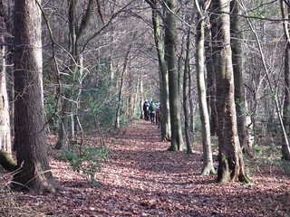
In Lownde's Wood
SWC Walk 140a Wendover to Great Missenden
Dec-15 • thomasgrabow on Flickr
walkicon swcwalks swcwalk140 23566114172
Sunset Chalkdell Wood, Great Missenden
SWC Walk 140a Wendover to Great Missenden
Dec-15 • thomasgrabow on Flickr
walkicon swcwalks swcwalk140 23648314586
| Length |
20.1 km (12.5 mi) with 401m ascent/descent. For a shorter walk or an Alternative Ending see below Walk Options. |
|---|---|
| Toughness |
5 out of 10, with 4 hours 45 minutes walking time. For the whole outing, including trains, sights and meals, allow at least 7 ½ hours. |
| Walk Notes |
This walk combines some of the finest elements of the Chiltern Hills, while having very little overlap with other walks in the area. After leaving Wendover in a south easterly direction on the Ridgeway the walk rises into woods, which are rich in Bluebells in springtime. It then passes along fields to get to the picturesque green in The Lee, a conservation area village. From there it continues through woodland and the beautiful Lee Common to a 16th century lunch pub at Swan Bottom. After crossing some more fields, the afternoon section then leads entirely through woods right up to the outskirts of Wendover: it re-joins the Ridgeway for a while and then descends steeply off the escarpment down an ancient Holloway. Only to rise again, on forest tracks with some magnificent panoramic views , until getting to the highest point of the walk in the middle of Wendover Woods. From there the route to Wendover meanders through the woods, passing a wildlife hide and an ancient hill-fort site, before descending steeply to the plains. |
| Walk Options |
Shortcuts: It is possible to shorten the walk in three ways, shortcuts II and III are mutually exclusive;
Alternative Ending in Great Missenden: while the main walk leads almost entirely through woodland in the afternoon, this alternative offers constantly changing scenery. It avoids settlements and roads, mostly following grassy fields, while still passing through a variety of varied and characterful woods. Several beautiful valleys are crossed in between and the walk ends with a scenic descent into Great Missenden. 21.6 km (13.4 mi) with 359/355m ascent/descent and a 6/10 rating. |
| Maps | OS Explorer: 181 (Chiltern Hills North) and 172 (Chiltern Hills East; only for the Great Missenden ending)
OS Landranger: 165 (Aylesbury & Leighton Buzzard) |
| Travel |
Wendover Station, map reference SP 865 077, 7 km south east of Aylesbury and 131m above sea level. Great Missenden Station, map reference SP 892 013, 8 km north west of Amersham and 135m above sea level. Both are in Buckinghamshire. Trains go from Marylebone station, on an hourly service, journey time 49 minutes. Great Missenden (an alternative ending) is on the same line, one stop closer to London. Saturday Walkers' Club: Take the train closest to 9.30 hours. |
| Lunch |
The Cock and Rabbit Inn, The Lee, Buckinghamshire, HP16 9LZ (01494 837 540). Located 7.3 km (4.6 mi) from the start of the walk.
|
| Tea |
Wendover Ending
Great Missenden Ending
|
| Profile | |
|---|---|
| Help Us! |
After the walk, please leave a comment, it really helps. Thanks! You can also upload photos to the SWC Group on Flickr (upload your photos) and videos to Youtube. This walk's tags are: |
| By Train |
Out (not a train station) Back (not a train station) |
| By Car |
Start Map Directions |
| Amazon | |
| Help |
National Rail: 03457 48 49 50 • Traveline (bus times): 0871 200 22 33 (12p/min) • TFL (London) : 0343 222 1234 |
| Version |
Mar-25 Thomas G |
| Copyright | © Saturday Walkers Club. All Rights Reserved. No commercial use. No copying. No derivatives. Free with attribution for one time non-commercial use only. www.walkingclub.org.uk/site/license.shtml |

Walk Directions
Full directions for this walk are in a PDF file (link above) which you can print, or download on to a Kindle, tablet, or smartphone.
This is just the introduction. This walk's detailed directions are in a PDF available from wwww.walkingclub.org.uk