Thames Path : Greenwich to Woolwich Short Walk
A Fascinating Stretch of The Thames: Maritime Greenwich, Greenwich Peninsula, Charlton, Thames Barrier, Royal Woolwich Arsenal

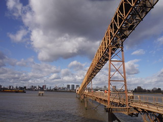
Angerstein Wharf, jetty out to shipping lane
SWC Short Walk 42 - Thames Path: Greenwich to Woolwich
Feb-20 • thomasgrabow on Flickr
swcwalks short42 banner 49556921558

Greenwich Foot Tunnel Entrance and Canary Wharf beyond
SWC Short Walk 42 - Thames Path: Greenwich to Woolwich
Nov-19 • thomasgrabow on Flickr
swcwalks short42 walkicon 49557645952

View Upstream from east of Woolwich Ferry
SWC Short Walk 42 - Thames Path: Greenwich to Woolwich
Nov-19 • thomasgrabow on Flickr
swcwalks short42 walkicon 49557645697

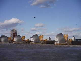
Thames Barrier at Storm Tide
SWC Short Walk 42 - Thames Path: Greenwich to Woolwich
Feb-20 • thomasgrabow on Flickr
swcwalks short42 walkicon 49556920308

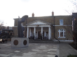
The Guard House bar & restaurant in the former Guard House, Woolwich Arsenal
SWC Short Walk 42 - Thames Path: Greenwich to Woolwich
Feb-20 • thomasgrabow on Flickr
swcwalks short42 walkicon 49557650342
| Length |
11.0 km/6.8 mi Start: Greenwich Station Finish: Woolwich Arsenal Station Time: 2 ½ hours |
|---|---|
| Transport |
Greenwich Station is in Zone 2 and served by Main Line Services on the North Kent Line from Charing Cross and Cannon Street to the Medway area (journey time from London Bridge: 8-9 minutes) and also by the DLR from the City to Lewisham (journey time from Bank: 20 minutes). Woolwich Arsenal Station is in Zone 4 and further east along the same Main Lines as Greenwich (journey time to London Bridge: from 21 minutes) and also the terminal of another arm of the DLR, with services from/to either Bank or Stratford International (both via City Airport and Canning Town). Woolwich will also be a stop on Crossrail, on the south easterly arm to Abbey Wood (journey time to Liverpool Street will be 17 minutes). |
| Walk Notes |
Follow quiet lanes from Greenwich Station to the Thames by the Cutty Sark and turn right downstream along this extremely fascinating stretch of London’s main river along Maritime Greenwich and around the rapidly changing Greenwich Peninsula with the O2-Dome and the ‘Emirates Air Line’ cable car as well as its views across the river to Canary Wharf, the Mouth of the River Lea and the Royal Victoria Dock, before walking past Charlton and the Thames Barrier, with Silvertown and its Tate & Lyle Sugar Refinery opposite, and on to the finish at the former Royal Arsenal site in Woolwich. You pass reminders of Britain’s great maritime past, many historic pubs, the imposing Greenwich Power Station, some new housing developments as well as some long-established industrial sites (including some spectacular Aggregates Businesses), some large outdoor artworks, an Ecology Park, Woolwich Dockyard and the refurbished Royal Arsenal site with its mixture of historic buildings, new and old housing, food & drink establishments and an Arts Centre (in development). Ways to shorten or (slightly) lengthen the route are described. |
| Walk Options |
Alternative Starts are possible from various points along the route (from 680m to 7.1 km into the walk). For details see the start of the Main Walk Directions. Finish at North Greenwich Underground by leaving the route: · either at the north westerly tip of the Greenwich Peninsula, 4.0 km into the walk; · or at the easterly side of the Greenwich Peninsula, 4.9 km into the walk. Use the Cross-Peninsula Shortcut (cut 1.1 km). Add a short loop through and/or around Greenwich Peninsula Ecology Park. Finish at Charlton Station, 830m off route, after 7.1 km of the walk. |
| Eat and Drink |
Refreshments en route:
Refreshments on the Cross-Peninsula Shortcut:
Refreshments near to and at the end of the walk:
|
| Thames Path |
This walk is part of the Thames Path [wikipedia] [National Trails] - a 184 mile national long distance path - that follows the Thames from its source in Kemble to the Thames Barrier at Charlton in SE London. There is an unofficial 10 mile south bank extension on to Crayford Ness. It follows the river's historic towpath where possible. In a few places, nearby paths are used instead as towpath sections do not match up where former "horse ferry" crossing have been lost. Through London, and on to the sea, there are north and south bank paths. |
|---|---|
| Profile | |
| Help Us! |
After the walk, please leave a comment, it really helps. Thanks! You can also upload photos to the SWC Group on Flickr (upload your photos) and videos to Youtube. This walk's tags are: |
| By Train |
Back (not a train station) |
| By Car |
Start Map Directions Finish Map Directions |
| Amazon | |
| Help |
National Rail: 03457 48 49 50 • Traveline (bus times): 0871 200 22 33 (12p/min) • TFL (London) : 0343 222 1234 |
| Version |
Oct-20 Thomas G |
| Copyright | © Saturday Walkers Club. All Rights Reserved. No commercial use. No copying. No derivatives. Free with attribution for one time non-commercial use only. www.walkingclub.org.uk/site/license.shtml |
Walk Directions
Full directions for this walk are in a PDF file (link above) which you can print, or download on to a Kindle, tablet, or smartphone.
This is just the introduction. This walk's detailed directions are in a PDF available from wwww.walkingclub.org.uk

